
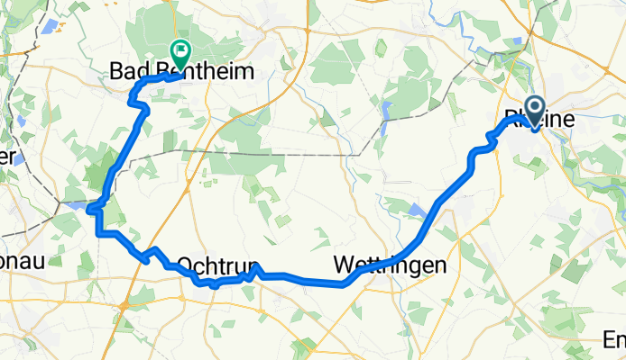
Rheine Neuenkirchen Ochtrup Bad Bentheim
A cycling route starting in Rheine, North Rhine-Westphalia, Germany.
Overview
About this route
Start: Rheine Bahnhof
-
Neuenkirchen
-
Wettringen
-
Ochtrup
-
Dreiländersee
-
Ziel: Schloss Bad Bentheim
- -:--
- Duration
- 45.1 km
- Distance
- 99 m
- Ascent
- 59 m
- Descent
- ---
- Avg. speed
- ---
- Avg. speed
Route quality
Waytypes & surfaces along the route
Waytypes
Path
26.1 km
(58 %)
Quiet road
12.1 km
(27 %)
Surfaces
Paved
27.6 km
(61 %)
Unpaved
5 km
(11 %)
Asphalt
26.4 km
(59 %)
Unpaved (undefined)
3.2 km
(7 %)
Route highlights
Points of interest along the route
Point of interest after 9.1 km
Offlumer See
Point of interest after 22.2 km
Abzweig FOC Ochtrup
Point of interest after 34.2 km
Abzweig Dreiländersee / Rüenberger Venn
Continue with Bikemap
Use, edit, or download this cycling route
You would like to ride Rheine Neuenkirchen Ochtrup Bad Bentheim or customize it for your own trip? Here is what you can do with this Bikemap route:
Free features
- Save this route as favorite or in collections
- Copy & plan your own version of this route
- Sync your route with Garmin or Wahoo
Premium features
Free trial for 3 days, or one-time payment. More about Bikemap Premium.
- Navigate this route on iOS & Android
- Export a GPX / KML file of this route
- Create your custom printout (try it for free)
- Download this route for offline navigation
Discover more Premium features.
Get Bikemap PremiumFrom our community
Other popular routes starting in Rheine
 Rheine-Hörstel-Nasses Dreieck CLONED FROM ROUTE 71643
- Distance
- 32.4 km
- Ascent
- 61 m
- Descent
- 65 m
- Location
- Rheine, North Rhine-Westphalia, Germany
 Radbahn Münsterland
- Distance
- 36.4 km
- Ascent
- 101 m
- Descent
- 53 m
- Location
- Rheine, North Rhine-Westphalia, Germany
 Rheine - Haddorf - Neuenkirchen - Rheine
- Distance
- 22 km
- Ascent
- 45 m
- Descent
- 47 m
- Location
- Rheine, North Rhine-Westphalia, Germany
 Rheine-Tecklenburg
- Distance
- 73.5 km
- Ascent
- 285 m
- Descent
- 283 m
- Location
- Rheine, North Rhine-Westphalia, Germany
 Hermannsweg I
- Distance
- 46.5 km
- Ascent
- 172 m
- Descent
- 171 m
- Location
- Rheine, North Rhine-Westphalia, Germany
 Hase-Ems-Weg - 1 Tag
- Distance
- 41.7 km
- Ascent
- 63 m
- Descent
- 75 m
- Location
- Rheine, North Rhine-Westphalia, Germany
 Elte-Emsdetten-Neuenkirchen-Tour
- Distance
- 44.7 km
- Ascent
- 84 m
- Descent
- 83 m
- Location
- Rheine, North Rhine-Westphalia, Germany
 Nasses Eck - Elte
- Distance
- 30 km
- Ascent
- 58 m
- Descent
- 56 m
- Location
- Rheine, North Rhine-Westphalia, Germany
Open it in the app