
Rundtour Steyr - St. Peter i.d. Au
A cycling route starting in Steyr, Upper Austria, Austria.
Overview
About this route
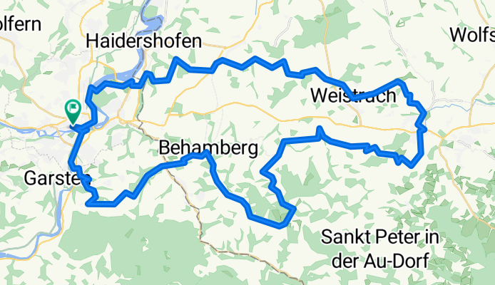
Rundtour von Steyr über Trostberg nach St. Peter in der Au und zurück über Behamberg und St. Ulrich nach Steyr
- -:--
- Duration
- 57.5 km
- Distance
- 734 m
- Ascent
- 734 m
- Descent
- ---
- Avg. speed
- ---
- Avg. speed
Route quality
Waytypes & surfaces along the route
Waytypes
Quiet road
28.8 km
(50 %)
Road
20.2 km
(35 %)
Surfaces
Paved
22.3 km
(39 %)
Unpaved
1.5 km
(3 %)
Asphalt
21.5 km
(37 %)
Loose gravel
1.1 km
(2 %)
Continue with Bikemap
Use, edit, or download this cycling route
You would like to ride Rundtour Steyr - St. Peter i.d. Au or customize it for your own trip? Here is what you can do with this Bikemap route:
Free features
- Save this route as favorite or in collections
- Copy & plan your own version of this route
- Sync your route with Garmin or Wahoo
Premium features
Free trial for 3 days, or one-time payment. More about Bikemap Premium.
- Navigate this route on iOS & Android
- Export a GPX / KML file of this route
- Create your custom printout (try it for free)
- Download this route for offline navigation
Discover more Premium features.
Get Bikemap PremiumFrom our community
Other popular routes starting in Steyr
 Steel-Town-Man extended
- Distance
- 72.5 km
- Ascent
- 664 m
- Descent
- 662 m
- Location
- Steyr, Upper Austria, Austria
 Steyr - Schoberstein
- Distance
- 28.6 km
- Ascent
- 1,010 m
- Descent
- 349 m
- Location
- Steyr, Upper Austria, Austria
 Steyrtalrunde
- Distance
- 27 km
- Ascent
- 434 m
- Descent
- 433 m
- Location
- Steyr, Upper Austria, Austria
 Fit in den Frühling
- Distance
- 39.2 km
- Ascent
- 686 m
- Descent
- 600 m
- Location
- Steyr, Upper Austria, Austria
 Damberg Time Trial (Profactor Teststrecke)
- Distance
- 11.3 km
- Ascent
- 481 m
- Descent
- 60 m
- Location
- Steyr, Upper Austria, Austria
 Pöchhacker Steyr - Reichraming - retour. Ennsradweg.
- Distance
- 66.3 km
- Ascent
- 657 m
- Descent
- 664 m
- Location
- Steyr, Upper Austria, Austria
 Steyrtalweg-Hintergebirgsweg
- Distance
- 164.2 km
- Ascent
- 3,438 m
- Descent
- 3,440 m
- Location
- Steyr, Upper Austria, Austria
 Steyr day 1
- Distance
- 14.6 km
- Ascent
- 268 m
- Descent
- 269 m
- Location
- Steyr, Upper Austria, Austria
Open it in the app