

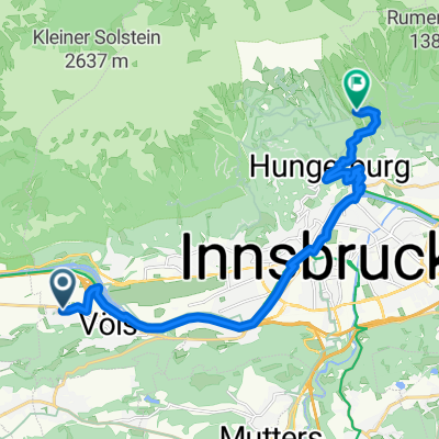
Innsbruck Airport-Innsbruck H.bahnhof
A cycling route starting in Völs, Tyrol, Austria.
Overview
About this route
- -:--
- Duration
- 4.8 km
- Distance
- 6 m
- Ascent
- 5 m
- Descent
- ---
- Avg. speed
- ---
- Max. altitude

Route quality
Waytypes & surfaces along the route
Waytypes
Quiet road
2 km
(41 %)
Road
1.5 km
(31 %)
Surfaces
Paved
4.4 km
(91 %)
Asphalt
3.7 km
(77 %)
Paved (undefined)
0.7 km
(14 %)
Undefined
0.4 km
(9 %)
Continue with Bikemap
Use, edit, or download this cycling route
You would like to ride Innsbruck Airport-Innsbruck H.bahnhof or customize it for your own trip? Here is what you can do with this Bikemap route:
Free features
- Save this route as favorite or in collections
- Copy & plan your own version of this route
- Sync your route with Garmin or Wahoo
Premium features
Free trial for 3 days, or one-time payment. More about Bikemap Premium.
- Navigate this route on iOS & Android
- Export a GPX / KML file of this route
- Create your custom printout (try it for free)
- Download this route for offline navigation
Discover more Premium features.
Get Bikemap PremiumFrom our community
Other popular routes starting in Völs
 Maximilianstraße, Völs nach Rosnerweg, Innsbruck
- Distance
- 15.8 km
- Ascent
- 664 m
- Descent
- 181 m
- Location
- Völs, Tyrol, Austria
 Kühtai Sattel 2009
- Distance
- 55.3 km
- Ascent
- 1,805 m
- Descent
- 1,740 m
- Location
- Völs, Tyrol, Austria
 A12, Völs nach Postplatz, Nassereith
- Distance
- 49.1 km
- Ascent
- 1,251 m
- Descent
- 988 m
- Location
- Völs, Tyrol, Austria
 Innsbruck Route Großer Solberg
- Distance
- 17.4 km
- Ascent
- 2,216 m
- Descent
- 2,214 m
- Location
- Völs, Tyrol, Austria
 Anna-Dengel-Straße, Innsbruck nach Anna-Dengel-Straße, Innsbruck
- Distance
- 21.1 km
- Ascent
- 225 m
- Descent
- 220 m
- Location
- Völs, Tyrol, Austria
 Inn túra 6.nap
- Distance
- 89.3 km
- Ascent
- 29 m
- Descent
- 119 m
- Location
- Völs, Tyrol, Austria
 Kühtai Haimingerberg
- Distance
- 94.8 km
- Ascent
- 1,570 m
- Descent
- 1,568 m
- Location
- Völs, Tyrol, Austria
 Campingplatz Kranebitten - Höttinger Alm
- Distance
- 12.8 km
- Ascent
- 996 m
- Descent
- 122 m
- Location
- Völs, Tyrol, Austria
Open it in the app