
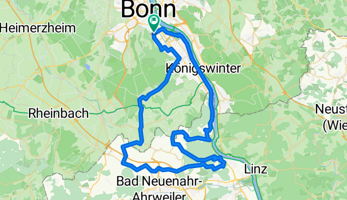
Bonn - Remagen - Bonn
A cycling route starting in Bonn, North Rhine-Westphalia, Germany.
Overview
About this route
Landschaftlich sehr schöne Runde. Im Sommer dürfte der Teil am Rhein lang etwas anstrengend werden.
Insgesamt ist die Route recht verkehrsarm. Nur das kurze Stück B9 ist etwas unangenehm zu fahren. Wenn man das geschafft hat wird man aber mit einem 13% Anstieg nach Bansdorf "belohnt" ;-)
Der Rückweg über Bad Godesberg war dem Wetter geschuldet, da im Kottenforst noch zu viel Eis und Schnee lag. Ansonsten sollte man aber ab Villiprott den Weg durch den Kottenforst wählen. Man trifft dann an der Annaberger Straße wieder auf die eingezeichnete Route.
- -:--
- Duration
- 71.6 km
- Distance
- 758 m
- Ascent
- 746 m
- Descent
- ---
- Avg. speed
- 249 m
- Avg. speed
Route quality
Waytypes & surfaces along the route
Waytypes
Road
21.6 km
(30 %)
Busy road
19.6 km
(27 %)
Surfaces
Paved
56.8 km
(79 %)
Unpaved
0.3 km
(<1 %)
Asphalt
53.2 km
(74 %)
Paving stones
2.8 km
(4 %)
Continue with Bikemap
Use, edit, or download this cycling route
You would like to ride Bonn - Remagen - Bonn or customize it for your own trip? Here is what you can do with this Bikemap route:
Free features
- Save this route as favorite or in collections
- Copy & plan your own version of this route
- Sync your route with Garmin or Wahoo
Premium features
Free trial for 3 days, or one-time payment. More about Bikemap Premium.
- Navigate this route on iOS & Android
- Export a GPX / KML file of this route
- Create your custom printout (try it for free)
- Download this route for offline navigation
Discover more Premium features.
Get Bikemap PremiumFrom our community
Other popular routes starting in Bonn
 T-Mobile-Rheinauen-Mehlem-Köwi-Dollendorf-Rheinauen-T-Mobile
- Distance
- 15.6 km
- Ascent
- 50 m
- Descent
- 50 m
- Location
- Bonn, North Rhine-Westphalia, Germany
 BRT2016-FR: An Rhein und Sieg - PSF des Radsportbezirk Mittelrhein-Süd beim BRT 2016 in Bonn - 76 km Strecke
- Distance
- 74.9 km
- Ascent
- 509 m
- Descent
- 509 m
- Location
- Bonn, North Rhine-Westphalia, Germany
 Auf den Feldern zwischen Köln und Troisdorf
- Distance
- 29.5 km
- Ascent
- 23 m
- Descent
- 24 m
- Location
- Bonn, North Rhine-Westphalia, Germany
 kleine McDrive-Runde (Ittenbach)
- Distance
- 40.7 km
- Ascent
- 437 m
- Descent
- 437 m
- Location
- Bonn, North Rhine-Westphalia, Germany
 Flach um Bonn
- Distance
- 56.6 km
- Ascent
- 186 m
- Descent
- 186 m
- Location
- Bonn, North Rhine-Westphalia, Germany
 BRT2016-MI: In den Westerwald - PSF des Radsportbezirk Mittelrhein-Süd beim BRT 2016 in Bonn - 70 km Strecke
- Distance
- 76.8 km
- Ascent
- 561 m
- Descent
- 561 m
- Location
- Bonn, North Rhine-Westphalia, Germany
 Bonn - Eifel - Westerwald - Bonn
- Distance
- 189.7 km
- Ascent
- 1,343 m
- Descent
- 1,341 m
- Location
- Bonn, North Rhine-Westphalia, Germany
 Bonn - Ahrquelle - Rursee - Köln
- Distance
- 154 km
- Ascent
- 987 m
- Descent
- 1,006 m
- Location
- Bonn, North Rhine-Westphalia, Germany
Open it in the app