
Day 3 - Dresden to Vienna
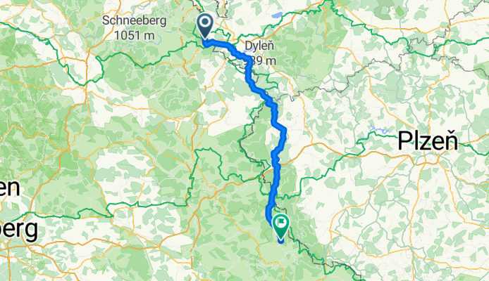
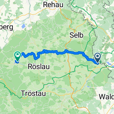
A cycling route starting in Hazlov, Karlovarský kraj, Czechia.
Overview
About this route
Hohenberg an der Eger to Treffelstein
- -:--
- Duration
- 113.9 km
- Distance
- 817 m
- Ascent
- 824 m
- Descent
- ---
- Avg. speed
- ---
- Max. altitude

Route quality
Waytypes & surfaces along the route
Waytypes
Road
48.5 km
(43 %)
Busy road
28.4 km
(25 %)
Surfaces
Paved
61.7 km
(54 %)
Unpaved
9.8 km
(9 %)
Asphalt
60.1 km
(53 %)
Gravel
7.3 km
(6 %)
Continue with Bikemap
Use, edit, or download this cycling route
You would like to ride Day 3 - Dresden to Vienna or customize it for your own trip? Here is what you can do with this Bikemap route:
Free features
- Save this route as favorite or in collections
- Copy & plan your own version of this route
- Split it into stages to create a multi-day tour
- Sync your route with Garmin or Wahoo
Premium features
Free trial for 3 days, or one-time payment. More about Bikemap Premium.
- Navigate this route on iOS & Android
- Export a GPX / KML file of this route
- Create your custom printout (try it for free)
- Download this route for offline navigation
Discover more Premium features.
Get Bikemap PremiumFrom our community
Other popular routes starting in Hazlov
 2010 Fichtelgebirgstour 3 Hohenberg-Weissenstadt
- Distance
- 35.7 km
- Ascent
- 394 m
- Descent
- 283 m
- Location
- Hazlov, Karlovarský kraj, Czechia
 2010 Fichtelgebirgstour 2 Hohenbergrunde
- Distance
- 17.4 km
- Ascent
- 345 m
- Descent
- 348 m
- Location
- Hazlov, Karlovarský kraj, Czechia
 Grenze Nord - Prag
- Distance
- 183.4 km
- Ascent
- 1,071 m
- Descent
- 1,324 m
- Location
- Hazlov, Karlovarský kraj, Czechia
 Fichtelgebirgstour 3 Hohenberg-Weissenstadt CLONED FROM ROUTE 514481
- Distance
- 35.8 km
- Ascent
- 405 m
- Descent
- 294 m
- Location
- Hazlov, Karlovarský kraj, Czechia
 09 Hazlov - Karlovy Vary
- Distance
- 64.2 km
- Ascent
- 177 m
- Descent
- 340 m
- Location
- Hazlov, Karlovarský kraj, Czechia
 VKZč 2019 - 1 - č 47/620
- Distance
- 48.1 km
- Ascent
- 653 m
- Descent
- 427 m
- Location
- Hazlov, Karlovarský kraj, Czechia
 Grenzlandradweg
- Distance
- 46.5 km
- Ascent
- 556 m
- Descent
- 488 m
- Location
- Hazlov, Karlovarský kraj, Czechia
 Libá nach Unnamed Road, Selber Forst
- Distance
- 6.5 km
- Ascent
- 2 m
- Descent
- 0 m
- Location
- Hazlov, Karlovarský kraj, Czechia
Open it in the app