
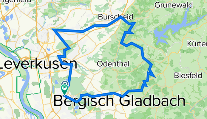
Quer durch den Bürgerbusch entlang des Wiembachtal/ Burscheid/Altenberg/Eikamp/Paffrath
A cycling route starting in Mülheim, North Rhine-Westphalia, Germany.
Overview
About this route
Durch den Bürgerbusch am Wiembach entlang bis nach Burscheid.Über das Eifgenbachtal nach Altenberg.An Altenberg vorbei durch das Pfengstbachtal. Das Foto zeigt eine der Brücken über die Dhünn in der Nähe des Märchenwaldes in Altenberg.
- -:--
- Duration
- 54.4 km
- Distance
- 507 m
- Ascent
- 511 m
- Descent
- ---
- Avg. speed
- ---
- Avg. speed

Continue with Bikemap
Use, edit, or download this cycling route
You would like to ride Quer durch den Bürgerbusch entlang des Wiembachtal/ Burscheid/Altenberg/Eikamp/Paffrath or customize it for your own trip? Here is what you can do with this Bikemap route:
Free features
- Save this route as favorite or in collections
- Copy & plan your own version of this route
- Sync your route with Garmin or Wahoo
Premium features
Free trial for 3 days, or one-time payment. More about Bikemap Premium.
- Navigate this route on iOS & Android
- Export a GPX / KML file of this route
- Create your custom printout (try it for free)
- Download this route for offline navigation
Discover more Premium features.
Get Bikemap PremiumFrom our community
Other popular routes starting in Mülheim
 warmrollen im bergischen land
- Distance
- 141.9 km
- Ascent
- 1,037 m
- Descent
- 1,037 m
- Location
- Mülheim, North Rhine-Westphalia, Germany
 Runde zum Fit bleiben
- Distance
- 34.9 km
- Ascent
- 375 m
- Descent
- 376 m
- Location
- Mülheim, North Rhine-Westphalia, Germany
 Neue Route durch den Königsforst
- Distance
- 69.1 km
- Ascent
- 244 m
- Descent
- 223 m
- Location
- Mülheim, North Rhine-Westphalia, Germany
 Rund um Colonias Grüngürtel linksrheinisch
- Distance
- 44.5 km
- Ascent
- 86 m
- Descent
- 89 m
- Location
- Mülheim, North Rhine-Westphalia, Germany
 Dünnthalsperren-Tour
- Distance
- 52.3 km
- Ascent
- 524 m
- Descent
- 510 m
- Location
- Mülheim, North Rhine-Westphalia, Germany
 E- Bike Bergisch Gladgach auch für das Trekkingbike geeignet.
- Distance
- 44.7 km
- Ascent
- 439 m
- Descent
- 437 m
- Location
- Mülheim, North Rhine-Westphalia, Germany
 Abendrunde
- Distance
- 40.9 km
- Ascent
- 518 m
- Descent
- 521 m
- Location
- Mülheim, North Rhine-Westphalia, Germany
 RTF Köln (Ford) 2007 2Pkt
- Distance
- 74.9 km
- Ascent
- 726 m
- Descent
- 703 m
- Location
- Mülheim, North Rhine-Westphalia, Germany
Open it in the app