

Portareasa-Piscul Voievoda
A cycling route starting in Lereşti, Arges, Romania.
Overview
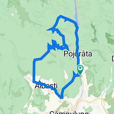
About this route
I interrupted the descent towards Campulung due to many fallen trees on the path.
At km 37, you can descend on a forest road towards Pojorata, shortening ~10 km.
- -:--
- Duration
- 53.9 km
- Distance
- 1,377 m
- Ascent
- 1,364 m
- Descent
- ---
- Avg. speed
- ---
- Max. altitude
Nagy Rudolf
created this 8 years ago
Continue with Bikemap
Use, edit, or download this cycling route
You would like to ride Portareasa-Piscul Voievoda or customize it for your own trip? Here is what you can do with this Bikemap route:
Free features
- Save this route as favorite or in collections
- Copy & plan your own version of this route
- Sync your route with Garmin or Wahoo
Premium features
Free trial for 3 days, or one-time payment. More about Bikemap Premium.
- Navigate this route on iOS & Android
- Export a GPX / KML file of this route
- Create your custom printout (try it for free)
- Download this route for offline navigation
Discover more Premium features.
Get Bikemap PremiumFrom our community
Other popular routes starting in Lereşti
- Iezer Enduro 2015 Rollo
- 7.3 km
- 24 m
- 1,197 m
- Lereşti, Arges, Romania
- tentativa de iezer 5 oct 2020
- 37.3 km
- 1,506 m
- 228 m
- Lereşti, Arges, Romania
- Portareasa-Vf iezerul mic-Crucea Ateneului-Vacarea-Cab Voina
- 40.7 km
- 1,587 m
- 1,587 m
- Lereşti, Arges, Romania
- Test Iezer
- 23.1 km
- 1,545 m
- 200 m
- Lereşti, Arges, Romania
- Iezer Vest
- 90.9 km
- 1,816 m
- 1,818 m
- Lereşti, Arges, Romania
- DJ734 808, Lerești to DJ734 808, Lerești
- 44.1 km
- 2,309 m
- 2,309 m
- Lereşti, Arges, Romania
- [2015.05.30] Tura Lac Rausor-Culmea Iezerul Mic-Cabana Voina
- 44.1 km
- 1,639 m
- 1,641 m
- Lereşti, Arges, Romania


![[2015.05.30] Tura Lac Rausor-Culmea Iezerul Mic-Cabana Voina](https://media.bikemap.net/routes/3051844/staticmaps/in_12d47039-d599-4bdb-90a3-6c0fb9ee1332_400x400_bikemap-2021-3D-static.png)
Open it in the app