
Cantavieja_ 2on-Op_B
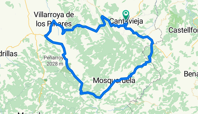
A cycling route starting in Cantavieja, Aragon, Spain.
Overview
About this route
Cantavieja-Fontanete-Villarroya...-Sollavientos-Valdelinares-Linares de Mora-Mosqueruela-La Iglesuela...-Cantavieja
- -:--
- Duration
- 118.7 km
- Distance
- 1,748 m
- Ascent
- 1,796 m
- Descent
- ---
- Avg. speed
- ---
- Max. altitude

Route quality
Waytypes & surfaces along the route
Waytypes
Road
24.9 km
(21 %)
Quiet road
3.6 km
(3 %)
Surfaces
Paved
53.4 km
(45 %)
Unpaved
1.2 km
(1 %)
Asphalt
53.4 km
(45 %)
Gravel
1.2 km
(1 %)
Undefined
64.1 km
(54 %)
Continue with Bikemap
Use, edit, or download this cycling route
You would like to ride Cantavieja_ 2on-Op_B or customize it for your own trip? Here is what you can do with this Bikemap route:
Free features
- Save this route as favorite or in collections
- Copy & plan your own version of this route
- Split it into stages to create a multi-day tour
- Sync your route with Garmin or Wahoo
Premium features
Free trial for 3 days, or one-time payment. More about Bikemap Premium.
- Navigate this route on iOS & Android
- Export a GPX / KML file of this route
- Create your custom printout (try it for free)
- Download this route for offline navigation
Discover more Premium features.
Get Bikemap PremiumFrom our community
Other popular routes starting in Cantavieja
 cantavieja (9) - teruel (10) -via verde
- Distance
- 85.4 km
- Ascent
- 1,388 m
- Descent
- 1,741 m
- Location
- Cantavieja, Aragon, Spain
 Calle Mayor, 1, Cantavieja naar CV-14, Morella
- Distance
- 37.2 km
- Ascent
- 232 m
- Descent
- 765 m
- Location
- Cantavieja, Aragon, Spain
 Cantavieja - Aliaga
- Distance
- 81.4 km
- Ascent
- 1,992 m
- Descent
- 2,182 m
- Location
- Cantavieja, Aragon, Spain
 Cantavieja_1er_B
- Distance
- 80.7 km
- Ascent
- 1,275 m
- Descent
- 1,303 m
- Location
- Cantavieja, Aragon, Spain
 Puerto cuarto pelado desde Cantavieja ida y vuelta
- Distance
- 42.5 km
- Ascent
- 715 m
- Descent
- 1,103 m
- Location
- Cantavieja, Aragon, Spain
 Cantavieja-Valdelinares-Jabalambre-Riodeba
- Distance
- 134.5 km
- Ascent
- 2,442 m
- Descent
- 2,097 m
- Location
- Cantavieja, Aragon, Spain
 Cantavieja_1er-A
- Distance
- 73.5 km
- Ascent
- 1,286 m
- Descent
- 1,289 m
- Location
- Cantavieja, Aragon, Spain
 SS19-6-Cantavieja-Ares del Maestrat
- Distance
- 34.5 km
- Ascent
- 478 m
- Descent
- 579 m
- Location
- Cantavieja, Aragon, Spain
Open it in the app