
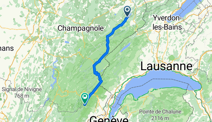
3 St.Point Lac - Lélex
A cycling route starting in Les Fourgs, Bourgogne-Franche-Comté, France.
Overview
About this route
Mehrtagestour Jura 3.Tag
- -:--
- Duration
- 75.9 km
- Distance
- 795 m
- Ascent
- 539 m
- Descent
- ---
- Avg. speed
- 1,150 m
- Max. altitude

Route quality
Waytypes & surfaces along the route
Waytypes
Busy road
28 km
(37 %)
Road
26.9 km
(35 %)
Surfaces
Paved
54.3 km
(71 %)
Unpaved
1.3 km
(2 %)
Asphalt
54.3 km
(71 %)
Unpaved (undefined)
1.3 km
(2 %)
Undefined
20.4 km
(27 %)
Continue with Bikemap
Use, edit, or download this cycling route
You would like to ride 3 St.Point Lac - Lélex or customize it for your own trip? Here is what you can do with this Bikemap route:
Free features
- Save this route as favorite or in collections
- Copy & plan your own version of this route
- Sync your route with Garmin or Wahoo
Premium features
Free trial for 3 days, or one-time payment. More about Bikemap Premium.
- Navigate this route on iOS & Android
- Export a GPX / KML file of this route
- Create your custom printout (try it for free)
- Download this route for offline navigation
Discover more Premium features.
Get Bikemap PremiumFrom our community
Other popular routes starting in Les Fourgs
 Boucle "Les Fourgs-Les Fourgs" via col de l'Aiguillon, le balcon du Jura, le val de Travers, l'Auberson
- Distance
- 76.4 km
- Ascent
- 1,136 m
- Descent
- 1,137 m
- Location
- Les Fourgs, Bourgogne-Franche-Comté, France
 2 Rund um Saint Point
- Distance
- 70.8 km
- Ascent
- 635 m
- Descent
- 627 m
- Location
- Les Fourgs, Bourgogne-Franche-Comté, France
 FA03 Chezery Forens
- Distance
- 98.8 km
- Ascent
- 893 m
- Descent
- 1,175 m
- Location
- Les Fourgs, Bourgogne-Franche-Comté, France
 64km-540Hm
- Distance
- 64.3 km
- Ascent
- 447 m
- Descent
- 449 m
- Location
- Les Fourgs, Bourgogne-Franche-Comté, France
 (03) St.Point-Lac - Gex
- Distance
- 93.3 km
- Ascent
- 859 m
- Descent
- 1,127 m
- Location
- Les Fourgs, Bourgogne-Franche-Comté, France
 Strecke2: Oye et Pallet - Vallée de Joux - Col de la Faucille - Gex
- Distance
- 97.4 km
- Ascent
- 1,136 m
- Descent
- 943 m
- Location
- Les Fourgs, Bourgogne-Franche-Comté, France
 St-Point - Frasne-Nozeroy-col Sorlin
- Distance
- 96.6 km
- Ascent
- 1,283 m
- Descent
- 1,282 m
- Location
- Les Fourgs, Bourgogne-Franche-Comté, France
 2 Rund um St.Point 2
- Distance
- 67.5 km
- Ascent
- 633 m
- Descent
- 633 m
- Location
- Les Fourgs, Bourgogne-Franche-Comté, France
Open it in the app