
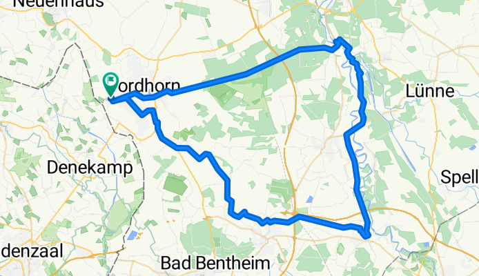
NOH-Rheine-NOH
A cycling route starting in Nordhorn, Lower Saxony, Germany.
Overview
About this route
- -:--
- Duration
- 72.9 km
- Distance
- 65 m
- Ascent
- 63 m
- Descent
- ---
- Avg. speed
- ---
- Avg. speed

Route quality
Waytypes & surfaces along the route
Waytypes
Quiet road
30.4 km
(42 %)
Path
18.5 km
(25 %)
Surfaces
Paved
48.8 km
(67 %)
Unpaved
12.7 km
(17 %)
Asphalt
37.9 km
(52 %)
Gravel
10.4 km
(14 %)
Continue with Bikemap
Use, edit, or download this cycling route
You would like to ride NOH-Rheine-NOH or customize it for your own trip? Here is what you can do with this Bikemap route:
Free features
- Save this route as favorite or in collections
- Copy & plan your own version of this route
- Sync your route with Garmin or Wahoo
Premium features
Free trial for 3 days, or one-time payment. More about Bikemap Premium.
- Navigate this route on iOS & Android
- Export a GPX / KML file of this route
- Create your custom printout (try it for free)
- Download this route for offline navigation
Discover more Premium features.
Get Bikemap PremiumFrom our community
Other popular routes starting in Nordhorn
 1. Versuch 13,56 in 43 min
- Distance
- 13.6 km
- Ascent
- 181 m
- Descent
- 193 m
- Location
- Nordhorn, Lower Saxony, Germany
 Kanalfahrt Nordhorn nach Almelo
- Distance
- 32.5 km
- Ascent
- 112 m
- Descent
- 114 m
- Location
- Nordhorn, Lower Saxony, Germany
 20170623_091808.gpx
- Distance
- 27.1 km
- Ascent
- 28 m
- Descent
- 26 m
- Location
- Nordhorn, Lower Saxony, Germany
 NOH-Grenz- Dinkel-Lage, Frenzwegen-NOH
- Distance
- 34 km
- Ascent
- 30 m
- Descent
- 26 m
- Location
- Nordhorn, Lower Saxony, Germany
 Kleine Tour Nordhorn mit Tierpark, ca. 21 km
- Distance
- 20.8 km
- Ascent
- 50 m
- Descent
- 50 m
- Location
- Nordhorn, Lower Saxony, Germany
 Nordhorn - Bookholt - Stadtflur - Klausheide - Flugplatz- Vechtesee
- Distance
- 30.4 km
- Ascent
- 29 m
- Descent
- 27 m
- Location
- Nordhorn, Lower Saxony, Germany
 Neubürgerroute 1
- Distance
- 17.9 km
- Ascent
- 22 m
- Descent
- 22 m
- Location
- Nordhorn, Lower Saxony, Germany
 Nordhorner Offroad
- Distance
- 43 km
- Ascent
- 25 m
- Descent
- 25 m
- Location
- Nordhorn, Lower Saxony, Germany
Open it in the app