
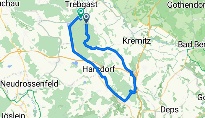
Trebgast - Oberlaitsch - Windrad - Ramsenthal - Harsdorf
A cycling route starting in Trebgast, Bavaria, Germany.
Overview
About this route
Mountainbikestrecke anfangs mit längerem Bergauftritt, auf Hochplateau flach mit schöner Aussicht, dann ab Galgenberg ein Höllenritt !
Forstwege, Waldwege, Wanderweg (Nortwaldweg).
Wenig Asphalt - hauptsächlich Radweg zwischen Harsdorf und Trebgast.
Keine Hauptstrassen !
- -:--
- Duration
- 16.9 km
- Distance
- 157 m
- Ascent
- 192 m
- Descent
- ---
- Avg. speed
- 484 m
- Avg. speed
Route quality
Waytypes & surfaces along the route
Waytypes
Quiet road
5.6 km
(33 %)
Pedestrian area
3.9 km
(23 %)
Surfaces
Paved
10.3 km
(61 %)
Unpaved
5.1 km
(30 %)
Asphalt
7.7 km
(45 %)
Gravel
3.9 km
(23 %)
Route highlights
Points of interest along the route

Point of interest after 3.6 km

Point of interest after 3.7 km

Point of interest after 3.9 km

Point of interest after 4.5 km
Links vom Weg ab. Auf der Höhe bleiben. Markanter Baum (siehe Bild) steht an Abzweigung auf rechter Seite.

Point of interest after 4.8 km
Schmaler Weg durch einen relativ dichten Wald. Kurzer Slalom.

Point of interest after 5.1 km
Oben auf der Höhe bleiben, d.h. links den Waldrand entlang. Immer Richtung Windrad.

Point of interest after 7.6 km
Galgenberg. Richtstätte vor 1000 Jahren

Point of interest after 8 km

Point of interest after 8.1 km

Point of interest after 8.2 km
Achtung. Etwa 100 m vom Wolkenbrunnen entfernt geht ein schmaler unscheinbarer Wanderpfad Richtung Tal - dieser hält uns auf der Route.
Continue with Bikemap
Use, edit, or download this cycling route
You would like to ride Trebgast - Oberlaitsch - Windrad - Ramsenthal - Harsdorf or customize it for your own trip? Here is what you can do with this Bikemap route:
Free features
- Save this route as favorite or in collections
- Copy & plan your own version of this route
- Sync your route with Garmin or Wahoo
Premium features
Free trial for 3 days, or one-time payment. More about Bikemap Premium.
- Navigate this route on iOS & Android
- Export a GPX / KML file of this route
- Create your custom printout (try it for free)
- Download this route for offline navigation
Discover more Premium features.
Get Bikemap PremiumFrom our community
Other popular routes starting in Trebgast
 Einkehr im Sonnenhof
- Distance
- 10.6 km
- Ascent
- 118 m
- Descent
- 38 m
- Location
- Trebgast, Bavaria, Germany
 Oberlaitscher Berg
- Distance
- 2.5 km
- Ascent
- 110 m
- Descent
- 0 m
- Location
- Trebgast, Bavaria, Germany
 2. Tag Trebgast-Bayreuth 04.07.17
- Distance
- 49.2 km
- Ascent
- 205 m
- Descent
- 193 m
- Location
- Trebgast, Bavaria, Germany
 Autofreier Sonntag Route 1
- Distance
- 20.1 km
- Ascent
- 401 m
- Descent
- 411 m
- Location
- Trebgast, Bavaria, Germany
 Runde Ideal
- Distance
- 12.4 km
- Ascent
- 157 m
- Descent
- 157 m
- Location
- Trebgast, Bavaria, Germany
 Einfach - Trebgast nach Kulmbach
- Distance
- 14.8 km
- Ascent
- 158 m
- Descent
- 174 m
- Location
- Trebgast, Bavaria, Germany
 2021 Trebgast Bischofsgrün Warmensteinach
- Distance
- 70.1 km
- Ascent
- 507 m
- Descent
- 500 m
- Location
- Trebgast, Bavaria, Germany
 Oberlaitschweg Trebgast - Windrad - Ramsenthal - Harsdorf
- Distance
- 19.4 km
- Ascent
- 203 m
- Descent
- 213 m
- Location
- Trebgast, Bavaria, Germany
Open it in the app