
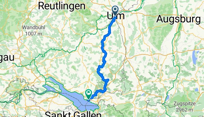
Donau-Bodensee-Radweg Start Ulm
A cycling route starting in Ulm, Baden-Württemberg, Germany.
Overview
About this route
Vom höchsten Kirchturm der Welt hinunter ans Ufer des Bodensees erstreckt sich die vom ADFC ausgezeichnete Qualitätsradroute des Donau-Bodensee-Radwegs.
- -:--
- Duration
- 159.1 km
- Distance
- 1,568 m
- Ascent
- 1,650 m
- Descent
- ---
- Avg. speed
- ---
- Avg. speed

Route quality
Waytypes & surfaces along the route
Waytypes
Quiet road
62.6 km
(39 %)
Road
35.9 km
(23 %)
Surfaces
Paved
134.3 km
(84 %)
Unpaved
3.2 km
(2 %)
Asphalt
131.9 km
(83 %)
Gravel
3 km
(2 %)
Continue with Bikemap
Use, edit, or download this cycling route
You would like to ride Donau-Bodensee-Radweg Start Ulm or customize it for your own trip? Here is what you can do with this Bikemap route:
Free features
- Save this route as favorite or in collections
- Copy & plan your own version of this route
- Sync your route with Garmin or Wahoo
Premium features
Free trial for 3 days, or one-time payment. More about Bikemap Premium.
- Navigate this route on iOS & Android
- Export a GPX / KML file of this route
- Create your custom printout (try it for free)
- Download this route for offline navigation
Discover more Premium features.
Get Bikemap PremiumFrom our community
Other popular routes starting in Ulm
 Ulm-Donau-Bodensee-Iller
- Distance
- 405.6 km
- Ascent
- 754 m
- Descent
- 753 m
- Location
- Ulm, Baden-Württemberg, Germany
 Ulm-Seissen-Ulm
- Distance
- 62.6 km
- Ascent
- 882 m
- Descent
- 859 m
- Location
- Ulm, Baden-Württemberg, Germany
 Ulm - Firedrichshafen (Bodensee)
- Distance
- 131.3 km
- Ascent
- 929 m
- Descent
- 969 m
- Location
- Ulm, Baden-Württemberg, Germany
 Ulm_Kempten_Lindau
- Distance
- 190.1 km
- Ascent
- 1,603 m
- Descent
- 1,682 m
- Location
- Ulm, Baden-Württemberg, Germany
 1.Etappe Ulm-Gardasee-Ulm
- Distance
- 137 km
- Ascent
- 417 m
- Descent
- 509 m
- Location
- Ulm, Baden-Württemberg, Germany
 Blaustein-Örlingen-Donau
- Distance
- 28.9 km
- Ascent
- 222 m
- Descent
- 219 m
- Location
- Ulm, Baden-Württemberg, Germany
 Hills @Blautal
- Distance
- 48.9 km
- Ascent
- 540 m
- Descent
- 540 m
- Location
- Ulm, Baden-Württemberg, Germany
 Donauradweg Ulm nach Passa_TheBest
- Distance
- 386.8 km
- Ascent
- 175 m
- Descent
- 351 m
- Location
- Ulm, Baden-Württemberg, Germany
Open it in the app