

S'Arraco>Sant Elm>Sa Tappa und zurück
A cycling route starting in Andratx, Balearic Islands, Spain.
Overview
About this route
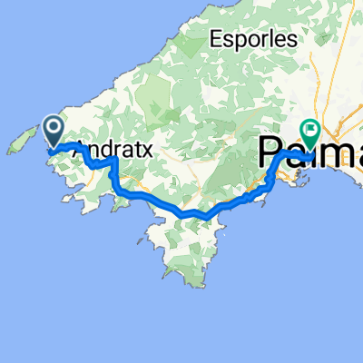
The route begins in the center of S'Arraco, after a moderate ascent you already get the first scenic highlight of the route, then a beautiful trail begins towards the lovely town of Sant Elm, which unfortunately is almost impassable on a stretch of about 1 km, so I had to push my MTB on this section, but the view of Sant Elm is very beautiful in some places. Upon arriving in Sant Elm, you pass through the village, then head towards the mountain Sa Trappe. At the foot of the mountain, the path starts to wind almost infinitely uphill, but once you reach the top, there's again a breathtaking view. Then you descend the path in reverse order, at the foot of the mountain you turn left and now there’s just a short distance to the start/finish. Now I wish you lots of fun...
- -:--
- Duration
- 19.4 km
- Distance
- 821 m
- Ascent
- 821 m
- Descent
- ---
- Avg. speed
- ---
- Max. altitude

Continue with Bikemap
Use, edit, or download this cycling route
You would like to ride S'Arraco>Sant Elm>Sa Tappa und zurück or customize it for your own trip? Here is what you can do with this Bikemap route:
Free features
- Save this route as favorite or in collections
- Copy & plan your own version of this route
- Sync your route with Garmin or Wahoo
Premium features
Free trial for 3 days, or one-time payment. More about Bikemap Premium.
- Navigate this route on iOS & Android
- Export a GPX / KML file of this route
- Create your custom printout (try it for free)
- Download this route for offline navigation
Discover more Premium features.
Get Bikemap PremiumFrom our community
Other popular routes starting in Andratx
 Andratx to Carrer de Simó Ballester, Palma
- Distance
- 39.8 km
- Ascent
- 875 m
- Descent
- 856 m
- Location
- Andratx, Balearic Islands, Spain
 Sierra de So na Vidala -20150913_102644.gpx
- Distance
- 14.4 km
- Ascent
- 615 m
- Descent
- 600 m
- Location
- Andratx, Balearic Islands, Spain
 Küste und Mehr
- Distance
- 72.8 km
- Ascent
- 1,227 m
- Descent
- 1,227 m
- Location
- Andratx, Balearic Islands, Spain
 Andratx Puigpunyent Banyalbufar
- Distance
- 60.7 km
- Ascent
- 1,120 m
- Descent
- 1,120 m
- Location
- Andratx, Balearic Islands, Spain
 Route in Andratx
- Distance
- 62.8 km
- Ascent
- 3,374 m
- Descent
- 3,385 m
- Location
- Andratx, Balearic Islands, Spain
 SanElmLaTrapaV1
- Distance
- 5.1 km
- Ascent
- 362 m
- Descent
- 9 m
- Location
- Andratx, Balearic Islands, Spain
 Andratx - Sóller
- Distance
- 60.1 km
- Ascent
- 3,553 m
- Descent
- 3,530 m
- Location
- Andratx, Balearic Islands, Spain
 Küstenklassiker
- Distance
- 123.5 km
- Ascent
- 4,780 m
- Descent
- 4,830 m
- Location
- Andratx, Balearic Islands, Spain
Open it in the app