
Laguiole à vélo
Découvre une carte de 92 itinéraires et pistes cyclables près de Laguiole, créés par notre communauté.
Portrait de région
Fais connaissance avec Laguiole
Trouve l’itinéraire à vélo qui te convient à Laguiole, où nous avons 92 pistes cyclables à explorer. La plupart des gens enfourchent leur vélo pour rouler ici aux mois de juillet et août.
6 556 km
Distance enregistrée
92
Itinéraires cyclables
1 317
Population
Communauté
Utilisateurs les plus actifs à Laguiole

De notre communauté
Les meilleurs itinéraires à vélo dans et autour de Laguiole


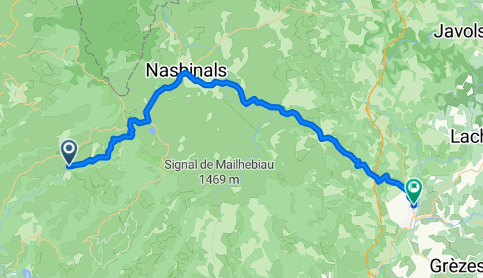
7.etapa St Chely d Aubrac - Le Malzieu-Ville
Itinéraire à vélo à Laguiole, Occitanie, France
Trasa je určena pro všechny typy kol.
Pro silniční kolo je však nutné v Montgrousset pokračovat po silnici D900 k odbočce na Marchastel (vynechat cestu přes travnaté pláně). Dále za vesnicí Rieutort d Aubrac pokrčovat na silnici D987 na Malbouzon, kde se silnice napojí na cestu D73 (vynechat "Poutní cestu").
kemp Le
Malzieu-Ville
Hezký kemp / teplá voda bez problému / příjemné sociální
zařízení / zásuvka se zemnícím kolíkem je pouze v kuchyňce (pro použití
rchlovarné konvice) / v umývárně jsou pouze zásuvky s dvěmi dírky a sice na
zářivkách nad umyvadlem (na mobily, holící strojky atd.) / Možnost spát i v
chatičkách, ale podrobnosti o tomto typu ubytování nemám. Není příjem mobilního
signálu.
Údaje z cyklocomputeru:trasa 86,29 km / nastoupáno 1432 metrů / 5:01:37 hod
- 80,6 km
- Distance
- 934 m
- Montée
- 877 m
- Descente

Ride Day 32—13 Oct 2005—48260 Recoules D'Aubrac (Nasbinals) to 15300 Murat
Itinéraire à vélo à Laguiole, Occitanie, France
<span style="font-size: 12pt; font-family: Arial;">Into every life, a little
rain must fall.<span> </span>Shortly after
starting out in the chilly morning, we donned our rain pants and booties due to
a light rain.<span> </span>While it never got
seriously heavy, it was more than light and continued steadily for several
hours.<span> </span>The most difficult part of
this was the descent from about 1050 M along D13 and D989 into Chaudes-Aigues
at about 750 M.<span> </span>Happily, while we
were climbing back to the 1000+ M level north of Chaudes-Aigues, the rain
lightened…and we even could see our shadows by the time we were on D16.<span> </span>We hadn’t expected such a nice end to
the day.</span>
<span style="font-size: 12pt; font-family: Arial;">As a final point, we left the Lozère Department and entered the Cantal
Department</span><span style="font-size: 12pt; font-family: Arial;"> just before entering St
Urcize</span><span style="font-size: 12pt; font-family: Arial;">.<span> </span>This also meant that
we passed from the Languedoc-Roussillon Region to the Auvergne Region</span>
<span style="font-size: 12pt; font-family: Arial;">Great low traffic roads.</span>
Background:<br /><br /><br />My wife and I have been doing self-supported tours in Western Europe (a majority in France) since 1993. This series of rides covers our 2005 2 month route through parts of France. Our beginning and ending point is near Chaduri (south of Angoulême) where our friends have a farm with Gites and Chambres d'Hotes.<br /><br /><br />We rode our Dawes touring bicycles purchased in 1993 heavily loaded with 700Cx32 tires. All of our riding was on paved roads, mostly with very little traffic.<br /><br /><br />If any questions, feel free to email me at jeffkadet@netdiving.com<br /><br /><br />Jeff
- 67,6 km
- Distance
- 587 m
- Montée
- 757 m
- Descente
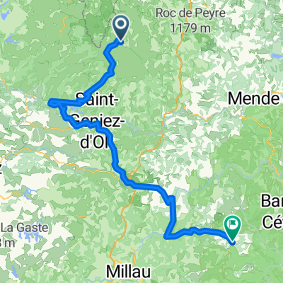
2014 Ride Day 99 - St-Chély-d'Aubrac to Marvejols
Itinéraire à vélo à Laguiole, Occitanie, France
Excellent low traffic roads and scenery until getting into Marvejols.
- 44,7 km
- Distance
- 673 m
- Montée
- 856 m
- Descente
Découvrez plus d'itinéraires
 09-MassifCentral
- Distance
- 60,8 km
- Montée
- 509 m
- Descente
- 1 057 m
- Emplacement
- Laguiole, Occitanie, France
 Nasbidaniel2
- Distance
- 60,7 km
- Montée
- 627 m
- Descente
- 627 m
- Emplacement
- Laguiole, Occitanie, France
 étape 5
- Distance
- 105 km
- Montée
- 1 228 m
- Descente
- 1 265 m
- Emplacement
- Laguiole, Occitanie, France
 TAP J 1
- Distance
- 78,4 km
- Montée
- 900 m
- Descente
- 1 474 m
- Emplacement
- Laguiole, Occitanie, France
 JATIENZA2
- Distance
- 44,1 km
- Montée
- 860 m
- Descente
- 858 m
- Emplacement
- Laguiole, Occitanie, France
 Laguiole - Viaduc de Garabit Etape 3
- Distance
- 67,3 km
- Montée
- 1 282 m
- Descente
- 1 505 m
- Emplacement
- Laguiole, Occitanie, France
 Route de Sainte-Urcize 21, Nasbinals nach Avenue Albert Thomas 23, Capdenac-Gare
- Distance
- 114 km
- Montée
- 2 345 m
- Descente
- 3 338 m
- Emplacement
- Laguiole, Occitanie, France
 Aveyron-Tag1--4-0719 Runde angepasst 2
- Distance
- 138,5 km
- Montée
- 1 438 m
- Descente
- 1 922 m
- Emplacement
- Laguiole, Occitanie, France