

Mae Rim to Huay Tueng Tao Offroad
Un itinéraire vélo au départ de Chiang Mai, Chiang Mai, Thaïlande.
Vue d'ensemble
À propos du circuit
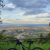
This is a 100% offroad ride predominantly on single track west of the military base in Mae Rim. Most of it runs through dense forest over undulating terrain. The trail is easy for the most part with some challenging sections (medium difficulty overall). The northern section beyond the lake has several stream crossings and g-outs dips with very deep ruts carved by years of motocross (ab-)use. The lake itself offers on-trail and off-trail riding along the shoreline with some bumps, drop-offs, guillies and other fun stuff. Just be imaginative and find your own line. On the weekend, there are many visitors at the lake.
- -:--
- Durée
- 12,8 km
- Distance
- 169 m
- Montée
- 169 m
- Descente
- ---
- Vit. moyenne
- ---
- Altitude max.

Continuer avec Bikemap
Utilise, modifie ou télécharge cet itinéraire vélo
Tu veux parcourir Mae Rim to Huay Tueng Tao Offroad ou l’adapter à ton propre voyage ? Voici ce que tu peux faire avec cet itinéraire Bikemap :
Fonctionnalités gratuites
- Enregistre cet itinéraire comme favori ou dans une collection
- Copie et planifie ta propre version de cet itinéraire
- Synchronise ton itinéraire avec Garmin ou Wahoo
Fonctionnalités Premium
Essai gratuit de 3 jours, ou paiement unique. En savoir plus sur Bikemap Premium.
- Navigue sur cet itinéraire sur iOS et Android
- Exporter un fichier GPX / KML de cet itinéraire
- Crée ton impression personnalisée (essaie-la gratuitement)
- Télécharge cet itinéraire pour la navigation hors ligne
Découvre plus de fonctionnalités Premium.
Obtiens Bikemap PremiumDe notre communauté
Chiang Mai : Autres itinéraires populaires qui commencent ici
 Reverse Samoeng Loop back via Bhubbing Palace
- Distance
- 116,8 km
- Montée
- 2 847 m
- Descente
- 2 847 m
- Emplacement
- Chiang Mai, Chiang Mai, Thaïlande
 Cycle in Thai 03 : Chiang Rai, Myanmar
- Distance
- 263,6 km
- Montée
- 781 m
- Descente
- 703 m
- Emplacement
- Chiang Mai, Chiang Mai, Thaïlande
 DoiSuthep
- Distance
- 49,9 km
- Montée
- 1 107 m
- Descente
- 1 109 m
- Emplacement
- Chiang Mai, Chiang Mai, Thaïlande
 Chiangmai U to Doi Su Thep view point
- Distance
- 18,1 km
- Montée
- 404 m
- Descente
- 403 m
- Emplacement
- Chiang Mai, Chiang Mai, Thaïlande
 Moderate Route in Chiang Mai
- Distance
- 7,4 km
- Montée
- 21 m
- Descente
- 18 m
- Emplacement
- Chiang Mai, Chiang Mai, Thaïlande
 Chiang Mai - Rim Ping
- Distance
- 65 km
- Montée
- 30 m
- Descente
- 29 m
- Emplacement
- Chiang Mai, Chiang Mai, Thaïlande
 MHS Loop
- Distance
- 533,7 km
- Montée
- 5 294 m
- Descente
- 5 289 m
- Emplacement
- Chiang Mai, Chiang Mai, Thaïlande
 MTCM - ITT Huay Tung Thao Lake
- Distance
- 8,3 km
- Montée
- 72 m
- Descente
- 78 m
- Emplacement
- Chiang Mai, Chiang Mai, Thaïlande
Ouvre-la dans l’app