

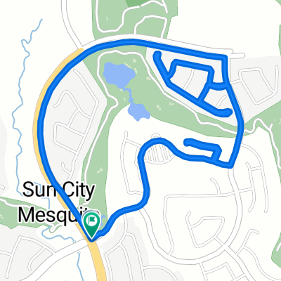
Sun City Bike Club Easy Ride 1 Out and Back Around Mesquite and Bunkerville
Un itinéraire vélo au départ de Mesquite, Nevada, États Unis.
Vue d'ensemble
À propos du circuit
This is a fairly flat and easy out and back ride from Sun City Mesquite. The ride starts with a mostly downhill ride to Sunset Greens; a slight uphill ride to Riverside Road (NV 170); a slight up and down ride to and through Bunkerville and back to Hafen Lane; a relatively flat ride back through the two roundabouts and passed West Pioneer Boulevard; then a pretty good climb to the finish. Total Ride Distance: 19.4 Miles.
Notes: 1. If you open the route in Google Roadmap or Google Hybrid (pulled down from the "Relief Map" tab) you will get a more up-to-date view of the roads and paths. Some of the other maps are dated. 2. Riverside Road can be ridden either on a pedestrian/bike path (shown on the map) or on the roadway itself. There is some traffic, particularly heading from Bunkerville back into Mesquite. 3. Part of the ride within the city of Mesquite is also on a separate pedestrian/bike path (shown on the map) starting off of Hafen Lane and ending at Old Mill Road. 4. This mapping program tends to under-compute the total ride mileage by roughly 10%, based on mileage for this ride when it has been actually ridden. - -:--
- Durée
- 31,3 km
- Distance
- 116 m
- Montée
- 117 m
- Descente
- ---
- Vit. moyenne
- ---
- Altitude max.
Qualité de l’itinéraire
Types de voies et surfaces le long de l’itinéraire
Types de routes
Piste cyclable
9,4 km
(30 %)
Route tranquille
6,9 km
(22 %)
surfaces
Pavé
22,8 km
(73 %)
Asphalte
17,8 km
(57 %)
Béton
4,4 km
(14 %)
Continuer avec Bikemap
Utilise, modifie ou télécharge cet itinéraire vélo
Tu veux parcourir Sun City Bike Club Easy Ride 1 Out and Back Around Mesquite and Bunkerville ou l’adapter à ton propre voyage ? Voici ce que tu peux faire avec cet itinéraire Bikemap :
Fonctionnalités gratuites
- Enregistre cet itinéraire comme favori ou dans une collection
- Copie et planifie ta propre version de cet itinéraire
- Synchronise ton itinéraire avec Garmin ou Wahoo
Fonctionnalités Premium
Essai gratuit de 3 jours, ou paiement unique. En savoir plus sur Bikemap Premium.
- Navigue sur cet itinéraire sur iOS et Android
- Exporter un fichier GPX / KML de cet itinéraire
- Crée ton impression personnalisée (essaie-la gratuitement)
- Télécharge cet itinéraire pour la navigation hors ligne
Découvre plus de fonctionnalités Premium.
Obtiens Bikemap PremiumDe notre communauté
Mesquite : Autres itinéraires populaires qui commencent ici
 870 Deep Gorge Trail, Mesquite to 1350 Flat Top Mesa Dr, Mesquite
- Distance
- 27,3 km
- Montée
- 281 m
- Descente
- 243 m
- Emplacement
- Mesquite, Nevada, États Unis
 Mesquite half loop.
- Distance
- 17,6 km
- Montée
- 253 m
- Descente
- 256 m
- Emplacement
- Mesquite, Nevada, États Unis
 Crescent Moon Crossing 830, Mesquite to Crescent Moon Bend 829, Mesquite
- Distance
- 3,4 km
- Montée
- 44 m
- Descente
- 45 m
- Emplacement
- Mesquite, Nevada, États Unis
 Sun City Bike Club Easy Ride 3 (Tannery Cove)
- Distance
- 4,5 km
- Montée
- 114 m
- Descente
- 114 m
- Emplacement
- Mesquite, Nevada, États Unis
 Cycle-a-thon for Cancer
- Distance
- 16,3 km
- Montée
- 132 m
- Descente
- 162 m
- Emplacement
- Mesquite, Nevada, États Unis
 1350 Flat Top Mesa Dr, Mesquite to 1173 Clouds Rest Pt, Mesquite
- Distance
- 0,9 km
- Montée
- 21 m
- Descente
- 32 m
- Emplacement
- Mesquite, Nevada, États Unis
 Recovered Route
- Distance
- 12,1 km
- Montée
- 278 m
- Descente
- 231 m
- Emplacement
- Mesquite, Nevada, États Unis
 Settlers Way, Mesquite to 1350 Flat Top Mesa Dr, Mesquite
- Distance
- 15,1 km
- Montée
- 232 m
- Descente
- 194 m
- Emplacement
- Mesquite, Nevada, États Unis
Ouvre-la dans l’app