

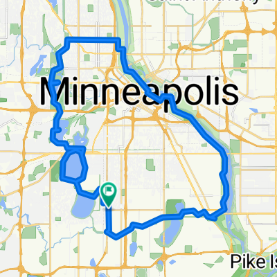
B2B00382 55423 > 55407 via 12th, 15th, Bloomington
Un itinéraire vélo au départ de Richfield, Minnesota, États Unis.
Vue d'ensemble
À propos du circuit
Take 69th east to 12th Ave.
Left onto 12th Ave, and take 12th Ave north to 64th St.
Right onto 64th to Bloomington.
Left on Bloomington, and bike alongside the park heading north.
At the edge of the park, a bridge will appear to your left.
Take bridge over 62. Once over the bridge, hang a left onto 60th St.
Go right onto 12th Ave, and continue on 12th up to 47th.
Take a right onto 47th St and take that to 15th Ave.
Take a left onto 15th and take it to 32nd St.
Take a left onto 32nd, a quick right onto 14th Ave, and a left onto Powderhorn Terrace.
Powderhorn Terrace will curve to the right (curve north) and become 12th Ave.
Take that one block to 31st St, and take a left.
Take 31st St west to Park Ave. (note: on the way to Park, you'll cross Chicago where 1st juts slightly to the right, but keep heading west on 31st west).
Take a right onto Park and take the bikelane north to 28th.
Take a right on 28th and head a couple blocks to destination. (note, 28th St is one-way, and occasionally has a lot of traffic. An alternative is to walk the last 2 blocks on the sidewalk).
- -:--
- Durée
- 11,3 km
- Distance
- 34 m
- Montée
- 28 m
- Descente
- ---
- Vit. moyenne
- 264 m
- Altitude max.
Qualité de l’itinéraire
Types de voies et surfaces le long de l’itinéraire
Types de routes
Route tranquille
7,5 km
(67 %)
Route
2,3 km
(20 %)
surfaces
Pavé
1,9 km
(17 %)
Asphalte
1,9 km
(17 %)
Indéfini
9,3 km
(83 %)
Continuer avec Bikemap
Utilise, modifie ou télécharge cet itinéraire vélo
Tu veux parcourir B2B00382 55423 > 55407 via 12th, 15th, Bloomington ou l’adapter à ton propre voyage ? Voici ce que tu peux faire avec cet itinéraire Bikemap :
Fonctionnalités gratuites
- Enregistre cet itinéraire comme favori ou dans une collection
- Copie et planifie ta propre version de cet itinéraire
- Synchronise ton itinéraire avec Garmin ou Wahoo
Fonctionnalités Premium
Essai gratuit de 3 jours, ou paiement unique. En savoir plus sur Bikemap Premium.
- Navigue sur cet itinéraire sur iOS et Android
- Exporter un fichier GPX / KML de cet itinéraire
- Crée ton impression personnalisée (essaie-la gratuitement)
- Télécharge cet itinéraire pour la navigation hors ligne
Découvre plus de fonctionnalités Premium.
Obtiens Bikemap PremiumDe notre communauté
Richfield : Autres itinéraires populaires qui commencent ici
 31 Miles South to North, to Victory Memorial & Minnehaha
- Distance
- 50,9 km
- Montée
- 124 m
- Descente
- 124 m
- Emplacement
- Richfield, Minnesota, États Unis
 B2B00056 55407>55122 via Mnnhaha Pwy, Bg Rvrs Trl
- Distance
- 17,7 km
- Montée
- 99 m
- Descente
- 109 m
- Emplacement
- Richfield, Minnesota, États Unis
 B2B00042 55419 > 55422 via Greenway, Cedar Lake, and Theo Wirth
- Distance
- 13,3 km
- Montée
- 61 m
- Descente
- 59 m
- Emplacement
- Richfield, Minnesota, États Unis
 Perfect Circle Minneapolis Bike Route
- Distance
- 36,4 km
- Montée
- 117 m
- Descente
- 117 m
- Emplacement
- Richfield, Minnesota, États Unis
 B2B00001 55419 > 55416 via Lake Harriet, 38th, France
- Distance
- 8,4 km
- Montée
- 75 m
- Descente
- 76 m
- Emplacement
- Richfield, Minnesota, États Unis
 30 miler
- Distance
- 48,5 km
- Montée
- 308 m
- Descente
- 310 m
- Emplacement
- Richfield, Minnesota, États Unis
 East 46th Street 180, Minneapolis to Union Depot, Saint Paul
- Distance
- 22,2 km
- Montée
- 153 m
- Descente
- 185 m
- Emplacement
- Richfield, Minnesota, États Unis
 B2B00114 55409 >55414 via Park Ave and stone arch bridge
- Distance
- 9 km
- Montée
- 48 m
- Descente
- 57 m
- Emplacement
- Richfield, Minnesota, États Unis
Ouvre-la dans l’app