Com’è andare in bici a Ban Chang.

Ban Chang in bici

Scopri una mappa con 109 percorsi e sentieri ciclabili vicino a Ban Chang, creati dalla nostra community.

Ritratto della regione

Scopri Ban Chang

Trova il percorso in bici giusto per te a Ban Chang, dove abbiamo 109 percorsi ciclabili da esplorare. La maggior parte delle persone va in bici qui nei mesi di Gennaio e Maggio.

5.621 km

Distanza registrata

109

Percorsi ciclabili

28.204

Popolazione

Community

Utenti più attivi a Ban Chang

Dalla nostra comunità
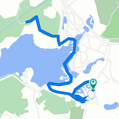
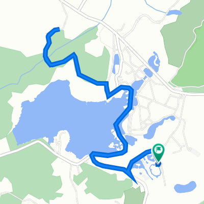
I migliori percorsi in bici a Ban Chang e dintorni

1

วัดเส้นทางใหม่

Percorso ciclabile a Ban Chang, Changwat Rayong, Thailand

42,5 km
Distanza
185 m
Salita
225 m
Discesa
MTS's Samersan Fish Market and Fishing Village Route
Bici da stradaMTBAsfaltato
mtsinternational
0

MTS's Samersan Fish Market and Fishing Village Route

Percorso ciclabile a Ban Chang, Changwat Rayong, Thailand

The MTS Samersan Fish Market and Fishing Village Bicycle Route utilizes paved roads with light to moderate vehicular traffic.  The route starts on Taseban 2/1 in Ban Chang just West and North of the West entrance to Eastern Star Golf Resort and heads N for .6 kilo to Sukhumvitt where the route heads West toward Sattahip.  At the Kilo Sip (10) intersection turn left and head South out toward Samersan and the Sattahip deep water Port.
40,8 km
Distanza
150 m
Salita
158 m
Discesa
0

Hokien Noodles/Brookside Ride

Percorso ciclabile a Ban Chang, Changwat Rayong, Thailand

141k Ban Chang to Rayong, Pae, Hokien Noodles, Brookside, Rayong, Ban Chang Bike Ride.
140,7 km
Distanza
247 m
Salita
248 m
Discesa
MTS Solo Route
Bici da stradaMTBAsfaltato
mtsinternational
1

MTS Solo Route

Percorso ciclabile a Ban Chang, Changwat Rayong, Thailand

Beginning on Taesaban 2/1 just Wast and North of the Eastern Star Resort West entrance, the route heads South to the beach then East paralleling the Gulf toward MapTaPut utilizing country sois with low volumne traffic.  The route turns North headed toward Sukhumvit Rd before reaching Maptaput then heads back to the West toward the starting point.  The roads are primarily flat and 99% paved.  Suitable for both mountain and road bikes.  The route travels through some eucalyptus and mango plantations and mostly country side.
32,5 km
Distanza
100 m
Salita
97 m
Discesa

Scopri più percorsi