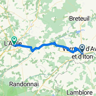
Verneuil-sur-Avre in bici
Scopri una mappa con 30 percorsi e sentieri ciclabili vicino a Verneuil-sur-Avre, creati dalla nostra community.
Ritratto della regione
Scopri Verneuil-sur-Avre
Trova il percorso in bici giusto per te a Verneuil-sur-Avre, dove abbiamo 30 percorsi ciclabili da esplorare.
1.405 km
Distanza registrata
30
Percorsi ciclabili
7229
Popolazione
Community
Utenti più attivi a Verneuil-sur-Avre
Dalla nostra comunità
I migliori percorsi in bici a Verneuil-sur-Avre e dintorni
2009 Euro Tour -- Ride Day 20 — 15 July 2009 — 27130 Verneuil-sur-Avre to 14100 Lisieux CLONED FROM ROUTE 1682062
Percorso ciclabile a Verneuil-sur-Avre, Normandy, France
<div class="MsoNormal" style="color: #000000; font-family: Helvetica; font-size: medium;"><span style="font-family: Arial;">
<div class="MsoNormal">
<div class="MsoNormal"><span style="font-family: Arial;">Nice ride today although we did have some strong headwinds.<span> </span>Happily in the latter half of the ride, we had some variety of terrain and excellent roads.</span></div>
<div class="MsoNormal"><span style="font-family: Arial;"> </span></div>
<div class="MsoNormal"><span style="font-family: Arial;">D137 had a terrible climb that warranted at least two arrows rather than the one arrow shown on the map.<span> </span>Right after the climb as we pedaled along D613 toward the Etap, it started to rain just as it had the previous day right before reaching our destination.</span></div>
</div>
<div class="MsoNormal"><br /></div>
</span><span style="font-family: Arial;">During the day, we passed for a couple of short periods from Eure Department in the Haute-Normandie Region into the Orne Department in the Basse-Normandie Region. Eventually, we exited the Eure Department and passed into the Calvados Department, which is in the Basse-Normandie Region.</span><span style="font-family: Arial;">
<div class="MsoNormal"><span style="font-family: Arial;"> </span></div>
</span></div>
<div class="MsoNormal" style="color: #000000; font-family: Helvetica; font-size: medium;"><span style="font-family: Arial;">
<div class="MsoNormal">
<div class="MsoNormal"></div>
</div>
</div>
<div class="MsoNormal"><br /></div>
</span></div>
<div class="MsoNormal" style="color: #000000; font-family: Helvetica; font-size: medium;">Background:<span style="font-family: Arial;">
<div class="MsoNormal" style="font-size: 16px;"><span style="font-family: Arial;"> </span></div>
</span></div>
My wife and I have been doing self-supported tours in Western Europe (a majority in France) since 1993. This series of rides covers our 2009 4.5 month route through parts of France, Germany, Austria, Switzerland, and then back to France. Our beginning and ending point is near Chadurie (south of Angouleme) where our friends have a farm with Gites and Chambres d'Hotes.
We rode our Dawes touring bicycles purchased in 1993 heavily loaded with 700Cx32 tires. All of our riding was on paved roads, mostly with very little traffic. Pretty much the only unpaved sections were some bicycle paths in Germany and Austria. Sadly, that wasn't so great as Helen fell a number of times on the unpaved paths. Fortunately, though, no serious injury.
If any questions, feel free to email me at jeffkadet@netdiving.com
Jeff
- 80,4 km
- Distanza
- 250 m
- Salita
- 281 m
- Discesa
Verneuil - Saint Sylvestre de Cormeilles
Percorso ciclabile a Verneuil-sur-Avre, Normandy, France
Verneuil - Saint Sylvestre de Cormeilles
- 93,5 km
- Distanza
- 168 m
- Salita
- 203 m
- Discesa
V2 Verneuil-s-Arve / Paris 140km
Percorso ciclabile a Verneuil-sur-Avre, Normandy, France
- 140,7 km
- Distanza
- 361 m
- Salita
- 475 m
- Discesa
Verneuil-Irai
Percorso ciclabile a Verneuil-sur-Avre, Normandy, France
- 24,9 km
- Distanza
- 101 m
- Salita
- 43 m
- Discesa
Scopri più percorsi
- 👌🏅
- Distanza
- 28,8 km
- Salita
- 234 m
- Discesa
- 232 m
- Posizione
- Verneuil-sur-Avre, Normandy, France
- Verneuil sur Avre - La Fresnaie fayel
- Distanza
- 63 km
- Salita
- 424 m
- Discesa
- 397 m
- Posizione
- Verneuil-sur-Avre, Normandy, France
- Verneuil d'Avre et d'Iton to Rue ville Close 3, Bellême
- Distanza
- 54 km
- Salita
- 571 m
- Discesa
- 523 m
- Posizione
- Verneuil-sur-Avre, Normandy, France
- 12–72 Route de Mortagne, Verneuil d'Avre et d'Iton à Les Barils
- Distanza
- 9,3 km
- Salita
- 164 m
- Discesa
- 142 m
- Posizione
- Verneuil-sur-Avre, Normandy, France
- Verneuil-sur-Avre - Cherré
- Distanza
- 84,4 km
- Salita
- 629 m
- Discesa
- 705 m
- Posizione
- Verneuil-sur-Avre, Normandy, France
- De Rue Aristide Briand, Verneuil d'Avre et d'Iton à 39 Rue Saint-Germain, Brezolles
- Distanza
- 13 km
- Salita
- 57 m
- Discesa
- 59 m
- Posizione
- Verneuil-sur-Avre, Normandy, France
- De Place Saint-Jean 151, Verneuil d'Avre et d'Iton à Grande Rue 47, Le Gault-Perche
- Distanza
- 100,5 km
- Salita
- 879 m
- Discesa
- 841 m
- Posizione
- Verneuil-sur-Avre, Normandy, France
- Verneuil sur Avre - Courtils
- Distanza
- 213,9 km
- Salita
- 570 m
- Discesa
- 716 m
- Posizione
- Verneuil-sur-Avre, Normandy, France