
Saint-Pons-de-Thomières in bici
Scopri una mappa con 68 percorsi e sentieri ciclabili vicino a Saint-Pons-de-Thomières, creati dalla nostra community.
Ritratto della regione
Scopri Saint-Pons-de-Thomières
Trova il percorso in bici giusto per te a Saint-Pons-de-Thomières, dove abbiamo 68 percorsi ciclabili da esplorare. La maggior parte delle persone va in bici qui nei mesi di Luglio e Agosto.
4.417 km
Distanza registrata
68
Percorsi ciclabili
2792
Popolazione
Community
Utenti più attivi a Saint-Pons-de-Thomières


Dalla nostra comunità
I migliori percorsi in bici a Saint-Pons-de-Thomières e dintorni


Saint-Pons-de-Thomières - Lamalou-les-Bains
Percorso ciclabile a Saint-Pons-de-Thomières, Occitanie, Francia
- 72,9 km
- Distanza
- 1.178 m
- Salita
- 1.284 m
- Discesa

Ride Day 22—3 Oct 2005—34220 St-Pons-de-Thomières to 81320 Murat-sur-Vèbre
Percorso ciclabile a Saint-Pons-de-Thomières, Occitanie, Francia
- 40,5 km
- Distanza
- 1.041 m
- Salita
- 511 m
- Discesa
Seque 3
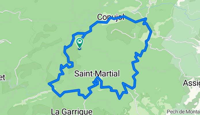
Percorso ciclabile a Saint-Pons-de-Thomières, Occitanie, Francia
- 36,6 km
- Distanza
- 599 m
- Salita
- 599 m
- Discesa

2019 Mazamet-Herepian
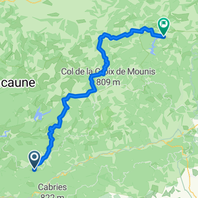
Percorso ciclabile a Saint-Pons-de-Thomières, Occitanie, Francia
- 13,2 km
- Distanza
- 177 m
- Salita
- 63 m
- Discesa
Scopri più percorsi
 Etape 15 – De Rodomouls à Lacan - Itinéraire Sud
- Distanza
- 16,9 km
- Salita
- 402 m
- Discesa
- 482 m
- Posizione
- Saint-Pons-de-Thomières, Occitanie, Francia
 Etape 16– De Lacan à Minerve - Itinéraire Sud
- Distanza
- 18,2 km
- Salita
- 501 m
- Discesa
- 790 m
- Posizione
- Saint-Pons-de-Thomières, Occitanie, Francia
 Leg 2 Day 4 kurz
- Distanza
- 113,1 km
- Salita
- 869 m
- Discesa
- 1.053 m
- Posizione
- Saint-Pons-de-Thomières, Occitanie, Francia
 st pons de thomieres to Saissac
- Distanza
- 84,2 km
- Salita
- 931 m
- Discesa
- 711 m
- Posizione
- Saint-Pons-de-Thomières, Occitanie, Francia
 Leg 2 Day 4
- Distanza
- 121,8 km
- Salita
- 966 m
- Discesa
- 1.150 m
- Posizione
- Saint-Pons-de-Thomières, Occitanie, Francia
 100 cols 30
- Distanza
- 70,6 km
- Salita
- 576 m
- Discesa
- 1.081 m
- Posizione
- Saint-Pons-de-Thomières, Occitanie, Francia
 2015_FR_110 km_1950hm
- Distanza
- 108,9 km
- Salita
- 1.522 m
- Discesa
- 1.601 m
- Posizione
- Saint-Pons-de-Thomières, Occitanie, Francia
 Etape 15– De Rodomouls à Lacan - Itinéraire Sud
- Distanza
- 17,2 km
- Salita
- 509 m
- Discesa
- 589 m
- Posizione
- Saint-Pons-de-Thomières, Occitanie, Francia