
Smokey Point in bici
Scopri una mappa con 19 percorsi e sentieri ciclabili vicino a Smokey Point, creati dalla nostra community.
Ritratto della regione
Scopri Smokey Point
Trova il percorso in bici giusto per te a Smokey Point, dove abbiamo 19 percorsi ciclabili da esplorare. La maggior parte delle persone va in bici qui nel mese di Maggio.
569 km
Distanza registrata
19
Percorsi ciclabili
1572
Popolazione
Community
Utenti più attivi a Smokey Point


Dalla nostra comunità
I migliori percorsi in bici a Smokey Point e dintorni


Arlington to Seattle
Percorso ciclabile a Smokey Point, Washington, Stati Uniti
- 97,6 km
- Distanza
- 1.514 m
- Salita
- 1.459 m
- Discesa

Easy ride in Arlington
Percorso ciclabile a Smokey Point, Washington, Stati Uniti
- 40,9 km
- Distanza
- 196 m
- Salita
- 195 m
- Discesa
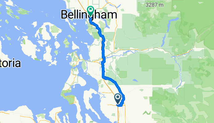
172nd St NE, Arlington to Lakeway Dr, Bellingham
Percorso ciclabile a Smokey Point, Washington, Stati Uniti
- 93,7 km
- Distanza
- 604 m
- Salita
- 593 m
- Discesa
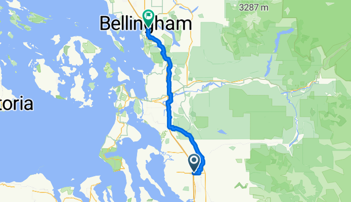
Smokey Point Dr, Arlington to Lakeway Dr, Bellingham
Percorso ciclabile a Smokey Point, Washington, Stati Uniti
- 92,3 km
- Distanza
- 964 m
- Salita
- 952 m
- Discesa
Scopri più percorsi
 15405 67th Ave NE, Arlington to 15405 67th Ave NE, Arlington
- Distanza
- 10,9 km
- Salita
- 69 m
- Discesa
- 70 m
- Posizione
- Smokey Point, Washington, Stati Uniti
 15405 67th Ave NE, Arlington to 15405 67th Ave NE, Arlington
- Distanza
- 11,1 km
- Salita
- 74 m
- Discesa
- 72 m
- Posizione
- Smokey Point, Washington, Stati Uniti
 18828 Smokey Point Blvd, Arlington to 14714–14798 Summers Dr, Mount Vernon
- Distanza
- 42,1 km
- Salita
- 330 m
- Discesa
- 348 m
- Posizione
- Smokey Point, Washington, Stati Uniti
 15291–15359 67th Ave NE, Arlington to 15405 67th Ave NE, Arlington
- Distanza
- 5,2 km
- Salita
- 23 m
- Discesa
- 23 m
- Posizione
- Smokey Point, Washington, Stati Uniti
 15405 67th Ave NE, Arlington to 15405 67th Ave NE, Arlington
- Distanza
- 11,1 km
- Salita
- 65 m
- Discesa
- 66 m
- Posizione
- Smokey Point, Washington, Stati Uniti
 15405 67th Ave NE, Arlington to 15405 67th Ave NE, Arlington
- Distanza
- 13 km
- Salita
- 118 m
- Discesa
- 116 m
- Posizione
- Smokey Point, Washington, Stati Uniti
 15405 67th Ave NE, Arlington to 15405 67th Ave NE, Arlington
- Distanza
- 11,1 km
- Salita
- 86 m
- Discesa
- 87 m
- Posizione
- Smokey Point, Washington, Stati Uniti
 hdjdj
hdjdj- Distanza
- 29,1 km
- Salita
- 653 m
- Discesa
- 634 m
- Posizione
- Smokey Point, Washington, Stati Uniti