
Lieto in bici
Scopri una mappa con 44 percorsi e sentieri ciclabili vicino a Lieto, creati dalla nostra community.
Ritratto della regione
Scopri Lieto
Trova il percorso in bici giusto per te a Lieto, dove abbiamo 44 percorsi ciclabili da esplorare.
1.157 km
Distanza registrata
44
Percorsi ciclabili
15.258
Popolazione
Community
Utenti più attivi a Lieto
Dalla nostra comunità
I migliori percorsi in bici a Lieto e dintorni
Lieto XCO 2014 Trail
Percorso ciclabile a Lieto, Varsinais-Suomi, Finlandia
1 round in Lieto XCO 2014 trail.
Today, for the first time will be able to ride all the ups and downs without foot contact with the ground :)
Lowest point 40m
Highest point 70m
Percent Slope (dst) 26,8%
- 3,6 km
- Distanza
- 68 m
- Salita
- 68 m
- Discesa
Oksvuoren kartoitusta
Percorso ciclabile a Lieto, Varsinais-Suomi, Finlandia
Polkujen hakemista ja kartoitusta.
Sahantietä pohjoiseen, poikkeaminen luoteeseen ennen taloa peltotielle joka jatkuu selvänä väylänä n.950m ja kyseiseltä väylältä on myös yhteys Lehtimäentielle mutta kun ajaakin mutkasta hiukan n.15m eteenpäin ja kääntyy vasemmalle eli luoteeseen metsään jossa menee selvä polku metsäautotien kääntöpaikalle.
Lähdeniitun viereinen peltotie oli melko haastavaa löysää hiekkatie osuutta, joten sen kautta ajaminen Lehtimäentielle ei kovinkaan kauska ja pellon luoteis kulmassa oli epävirallinen "Yksityistie" kyltti, Ei siellä kyl näkynyt siinä kohtaa asumusta.
Kilpijoentieltä menee Hultintielle aluksi pellon reunaa jonkin tapainen polku, (ettei tarvi, eikä saa, viljelyksillä painaa), joka jatkuu hyvänä peltotienä Hultintielle.
Hultintieltä kartan mukaanmyös yhteys Poson tielle.
Kyseiselle reitille sisältyy, metsäpolkuja, juurakoita kivikoita, kallioita, pelto, sora ja hiekkatie osuuksia vaihtelevasti, enimmäkseen helppoa metsätietä kuitenkin.
PS. jos on jälki joka päättyy ja palaa takaisin, niin kyseinen polku ei mielestäni johda oikein mihinkään muuhun kuin pusikkoon :)
- 15,6 km
- Distanza
- 59 m
- Salita
- 78 m
- Discesa
Lieto - Ukura, paths mapping
Percorso ciclabile a Lieto, Varsinais-Suomi, Finlandia
<div>
The route also goes through the forest logging area, where I tried cleaning up, bigger branches off to the side route. There was still a lot of branches that may degrade the transmission, so be careful. The logging area is approximately 100-200m after which it is already clear path. </div>
<div>
</div>
<div>
The route in the middle of a condition you see a big change to the south Esko-Ukura the road. the path is almost overgrown so I do not recommend it for much of that route. </div>
<div>
</div>
<div>
The route goes to the local horse-riding space area so be careful if traffic is horses, not afraid to try off-road cyclists. </div>
<div>
</div>
<div>
In fact, I use the time for ringing the bell, I will not suddenly the horse's field of vision.</div>
- 21,9 km
- Distanza
- 131 m
- Salita
- 131 m
- Discesa
Lieto- Kuninkaanlähde ( Source of the King) - Lieto
Percorso ciclabile a Lieto, Varsinais-Suomi, Finlandia
The source is the Old King's Road of Häme, along the watering place for horses.
The route is along the local roads, forest paths, twigs, stumps, rhizomes, horse stables, rock, rocks, asphalt road. Along the route there are two places where you can cool off with a swim though.
Source of the King and Mary gravel pit between the share is fixed because I forgot to put the Suunto Ambut 2 start the clock.
I edited or added to route Teijulan forest path, but I do not Keisvuoren rise and fall., which trail is good too.
- 51,6 km
- Distanza
- 205 m
- Salita
- 205 m
- Discesa
Scopri più percorsi
- Ukura Littoinen, some new trails
- Distanza
- 34,1 km
- Salita
- 210 m
- Discesa
- 210 m
- Posizione
- Lieto, Varsinais-Suomi, Finlandia
- Liesan maja, Kuokkapelto ja Keisvuori
- Distanza
- 14,6 km
- Salita
- 107 m
- Discesa
- 107 m
- Posizione
- Lieto, Varsinais-Suomi, Finlandia
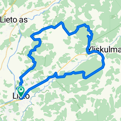
- Palovuori- Kietermäki- Tammi
- Distanza
- 24,9 km
- Salita
- 182 m
- Discesa
- 180 m
- Posizione
- Lieto, Varsinais-Suomi, Finlandia
- Ukura MTB Trails v2
- Distanza
- 87,3 km
- Salita
- 345 m
- Discesa
- 319 m
- Posizione
- Lieto, Varsinais-Suomi, Finlandia
- Palovuori v5
- Distanza
- 53,3 km
- Salita
- 278 m
- Discesa
- 289 m
- Posizione
- Lieto, Varsinais-Suomi, Finlandia
- Lieto- Ukura- Lieto
- Distanza
- 27,6 km
- Salita
- 180 m
- Discesa
- 182 m
- Posizione
- Lieto, Varsinais-Suomi, Finlandia
- Lieto- Turku- Lieto
- Distanza
- 60,6 km
- Salita
- 239 m
- Discesa
- 239 m
- Posizione
- Lieto, Varsinais-Suomi, Finlandia
- Liesan house and Lieto XCO 2013 route
- Distanza
- 16,9 km
- Salita
- 165 m
- Discesa
- 175 m
- Posizione
- Lieto, Varsinais-Suomi, Finlandia