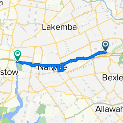
Com’è andare in bici a Bexley North.

Bexley North in bici

Scopri una mappa con 56 percorsi e sentieri ciclabili vicino a Bexley North, creati dalla nostra community.

Ritratto della regione

Scopri Bexley North

Trova il percorso in bici giusto per te a Bexley North, dove abbiamo 56 percorsi ciclabili da esplorare.

1.673 km

Distanza registrata

56

Percorsi ciclabili

3999

Popolazione

Community

Utenti più attivi a Bexley North

Dalla nostra comunità

I migliori percorsi in bici a Bexley North e dintorni

(Map 3) M5 Linear Park (Kingsgrove) to Bexley [via Bexley North]
MTBBicicletta da città
Dominic Galvin
1

(Map 3) M5 Linear Park (Kingsgrove) to Bexley [via Bexley North]

Percorso ciclabile a Bexley North, New South Wales, Australia

This route links the M5 Linear Park with the Bexley Bike Bus (Map 1) via laneways and quiet residential streets. See (Map 3D) for suggested upgrades to this route for Bayside Council and the NSW Government to deliver.
3,6 km
Distanza
31 m
Salita
4 m
Discesa
1

(Map 3D) M5 Linear Park to Bexley Pool

Percorso ciclabile a Bexley North, New South Wales, Australia

This map is for planning purposes and does not currently exist. This route relates to suggested upgrades to (Map 3) which it is requested that Bayside Council and the NSW Government deliver. Features include: A new tunnel or bridge to link the M5 Linear Park with Kookaburra Lane. An ATL along Bardwell Creek through vacant land. Utilisation of Preddys Lane and Council land to connect with Highgate St.
2,7 km
Distanza
32 m
Salita
16 m
Discesa
cooks River home loop
Bicicletta da cittàAsfaltato
2

cooks River home loop

Percorso ciclabile a Bexley North, New South Wales, Australia

10,2 km
Distanza
146 m
Salita
139 m
Discesa
Bexley North to Cooks River
Bici da stradaMTBBicicletta da città
Dominic Galvin
1

Bexley North to Cooks River

Percorso ciclabile a Bexley North, New South Wales, Australia

3,7 km
Distanza
32 m
Salita
45 m
Discesa

Scopri più percorsi