
Glenelg East in bici
Scopri una mappa con 79 percorsi e sentieri ciclabili vicino a Glenelg East, creati dalla nostra community.
Ritratto della regione
Scopri Glenelg East
Trova il percorso in bici giusto per te a Glenelg East, dove abbiamo 79 percorsi ciclabili da esplorare. La maggior parte delle persone va in bici qui nei mesi di Febbraio e Giugno.
3.017 km
Distanza registrata
79
Percorsi ciclabili
3701
Popolazione
Community
Utenti più attivi a Glenelg East


Dalla nostra comunità
I migliori percorsi in bici a Glenelg East e dintorni

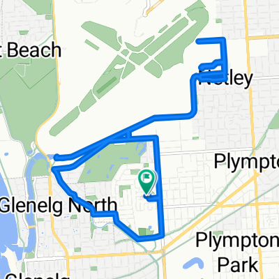
Camden Park - Marino Rocks - City Loop
Percorso ciclabile a Glenelg East, State of South Australia, Australia
- 48,3 km
- Distanza
- 241 m
- Salita
- 239 m
- Discesa

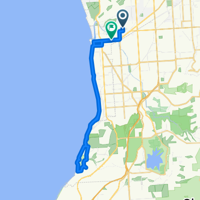
Easty ride west to Adelaide cityRoute to work
Percorso ciclabile a Glenelg East, State of South Australia, Australia
- 9 km
- Distanza
- 50 m
- Salita
- 8 m
- Discesa

Glenelg East to the Blanche Harbour Shacks
Percorso ciclabile a Glenelg East, State of South Australia, Australia
- 337,4 km
- Distanza
- 392 m
- Salita
- 397 m
- Discesa

Margie’s Way
Percorso ciclabile a Glenelg East, State of South Australia, Australia
- 9,9 km
- Distanza
- 36 m
- Salita
- 0 m
- Discesa
Scopri più percorsi
 42.5km along River Torrens/Mike Turtur
- Distanza
- 42,5 km
- Salita
- 196 m
- Discesa
- 194 m
- Posizione
- Glenelg East, State of South Australia, Australia
 Training - Home - Norton Summit - Lofty
- Distanza
- 59,2 km
- Salita
- 695 m
- Discesa
- 693 m
- Posizione
- Glenelg East, State of South Australia, Australia
 Camden Park to Dernancourt along the River Torrens
- Distanza
- 54,1 km
- Salita
- 204 m
- Discesa
- 204 m
- Posizione
- Glenelg East, State of South Australia, Australia
 Camden Park to Willunga Hill
- Distanza
- 98 km
- Salita
- 1.186 m
- Discesa
- 1.185 m
- Posizione
- Glenelg East, State of South Australia, Australia
 Scott Court to Scott Court
- Distanza
- 17,5 km
- Salita
- 37 m
- Discesa
- 39 m
- Posizione
- Glenelg East, State of South Australia, Australia
 451 ANZAC Highway, Camden Park to 46 Clifton Street, Camden Park
- Distanza
- 28,2 km
- Salita
- 6 m
- Discesa
- 14 m
- Posizione
- Glenelg East, State of South Australia, Australia
 Pine ave to south tce - Mike Turtur Bikeway
- Distanza
- 18,6 km
- Salita
- 61 m
- Discesa
- 61 m
- Posizione
- Glenelg East, State of South Australia, Australia
 Slow ride in Camden Park
- Distanza
- 32,5 km
- Salita
- 13 m
- Discesa
- 22 m
- Posizione
- Glenelg East, State of South Australia, Australia