
Giro veloce in bici da Villeurbanne a Caluire-et-Cuire
Personalizza il tuo percorso partendo dal nostro modello o scopri come la nostra community preferisce pedalare da Villeurbanne a Caluire-et-Cuire.
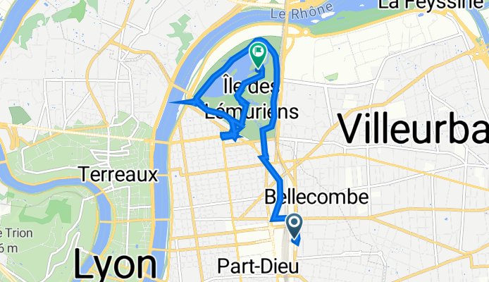
Modello di percorso
Da Villeurbanne a Caluire-et-Cuire

- 39 min
- Durata
- 11 km
- Distanza
- 118 m
- Salita
- 41 m
- Discesa
- 16,9 km/h
- Velocità media
- 252 m
- Altitudine max.
Hop on your bike in Villeurbanne, a lively suburb just northeast of Lyon, and roll towards Caluire-et-Cuire for an easy urban escape. This 11 km ride snakes mostly along paved cycleways and quiet roads—think smooth pedaling with very little traffic fuss. The route does climb a bit (about 118 meters total ascent), but you’ll be rewarded with fresh air and a little leg workout!
Start by weaving through Villeurbanne’s mix of residential neighborhoods and leafy parks, then track north-west, skirting the edges of Lyon’s famous Parc de la Tête d'Or—worth a short detour if you have time. As you approach Caluire-et-Cuire, the scenery shifts to peaceful streets and a more laid-back vibe. Caluire-et-Cuire sits just above the Rhône and Saône rivers, making it a popular residential area with great river views.
Nearly half the route is smooth cycleway, so you can just cruise and soak up the city sights. Don’t forget to grab a pastry or coffee when you arrive—Caluire-et-Cuire has some charming local spots to chill after your ride!
Community
Utenti migliori in questa regione


Dalla nostra comunità
I migliori percorsi in bici da Villeurbanne a Caluire-et-Cuire

Monts d'Or Attack #1
Percorso ciclabile a Villeurbanne, Alvernia-Rodano-Alpi, Francia
- 61,1 km
- Distanza
- 1.124 m
- Salita
- 1.115 m
- Discesa

Recovered Route
Percorso ciclabile a Villeurbanne, Alvernia-Rodano-Alpi, Francia
- 0,8 km
- Distanza
- 0 m
- Salita
- 0 m
- Discesa
Place Charles Béraudier 5, Lyon to Allée du Chalet 18, Lyon
Percorso ciclabile a Villeurbanne, Alvernia-Rodano-Alpi, Francia
- 7,8 km
- Distanza
- 11 m
- Salita
- 0 m
- Discesa

38 Rue du Progrès, Villeurbanne à 14 Rue de Nuits, Lyon
Percorso ciclabile a Villeurbanne, Alvernia-Rodano-Alpi, Francia
- 7 km
- Distanza
- 101 m
- Salita
- 19 m
- Discesa
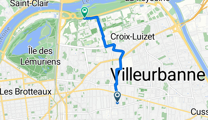
Rue Hippolyte Kahn, Villeurbanne à Avenue Pierre de Coubertin, Villeurbanne
Percorso ciclabile a Villeurbanne, Alvernia-Rodano-Alpi, Francia
- 3,1 km
- Distanza
- 20 m
- Salita
- 19 m
- Discesa

mont thou
Percorso ciclabile a Villeurbanne, Alvernia-Rodano-Alpi, Francia
- 35 km
- Distanza
- 694 m
- Salita
- 695 m
- Discesa

84 Rue d'Inkermann, Lyon à 8 Rue Paul Michel Perret, Lyon
Percorso ciclabile a Villeurbanne, Alvernia-Rodano-Alpi, Francia
- 2,2 km
- Distanza
- 6 m
- Salita
- 4 m
- Discesa

Quick bike tour through Lyon
Percorso ciclabile a Villeurbanne, Alvernia-Rodano-Alpi, Francia
- 9,4 km
- Distanza
- 53 m
- Salita
- 47 m
- Discesa

De Rue de la Cité 40, Lyon à Rue Sully 82, Lyon
Percorso ciclabile a Villeurbanne, Alvernia-Rodano-Alpi, Francia
- 3,2 km
- Distanza
- 0 m
- Salita
- 50 m
- Discesa

Retour Home
Percorso ciclabile a Villeurbanne, Alvernia-Rodano-Alpi, Francia
- 30,7 km
- Distanza
- 216 m
- Salita
- 207 m
- Discesa

Tete d'or 2
Percorso ciclabile a Villeurbanne, Alvernia-Rodano-Alpi, Francia
- 10,9 km
- Distanza
- 64 m
- Salita
- 64 m
- Discesa

Lyon #2
Percorso ciclabile a Villeurbanne, Alvernia-Rodano-Alpi, Francia
- 68,2 km
- Distanza
- 533 m
- Salita
- 544 m
- Discesa
Scopri più percorsi
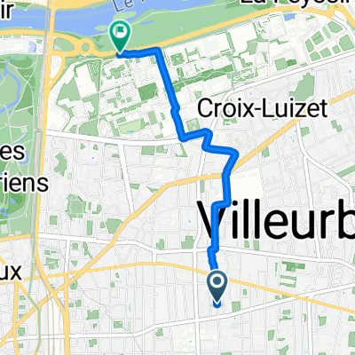 Rue Hippolyte Kahn, Villeurbanne à Avenue Pierre de Coubertin, Villeurbanne
- Distanza
- 3,1 km
- Salita
- 20 m
- Discesa
- 19 m
- Posizione
- Villeurbanne, Alvernia-Rodano-Alpi, Francia
 mont thou
- Distanza
- 35 km
- Salita
- 694 m
- Discesa
- 695 m
- Posizione
- Villeurbanne, Alvernia-Rodano-Alpi, Francia
 84 Rue d'Inkermann, Lyon à 8 Rue Paul Michel Perret, Lyon
- Distanza
- 2,2 km
- Salita
- 6 m
- Discesa
- 4 m
- Posizione
- Villeurbanne, Alvernia-Rodano-Alpi, Francia
 Quick bike tour through Lyon
- Distanza
- 9,4 km
- Salita
- 53 m
- Discesa
- 47 m
- Posizione
- Villeurbanne, Alvernia-Rodano-Alpi, Francia
 De Rue de la Cité 40, Lyon à Rue Sully 82, Lyon
- Distanza
- 3,2 km
- Salita
- 0 m
- Discesa
- 50 m
- Posizione
- Villeurbanne, Alvernia-Rodano-Alpi, Francia
 Retour Home
- Distanza
- 30,7 km
- Salita
- 216 m
- Discesa
- 207 m
- Posizione
- Villeurbanne, Alvernia-Rodano-Alpi, Francia
 Tete d'or 2
- Distanza
- 10,9 km
- Salita
- 64 m
- Discesa
- 64 m
- Posizione
- Villeurbanne, Alvernia-Rodano-Alpi, Francia
 Lyon #2
- Distanza
- 68,2 km
- Salita
- 533 m
- Discesa
- 544 m
- Posizione
- Villeurbanne, Alvernia-Rodano-Alpi, Francia
Percorsi da Villeurbanne
Giro veloce in bici da
Da Villeurbanne a Lione
Giro veloce in bici da
Da Villeurbanne a Bron
Percorsi verso Caluire-et-Cuire
Giro veloce in bici da
Da Lione a Caluire-et-Cuire