
Gita in bici di un giorno da Minneapolis a Saint Paul
Personalizza il tuo percorso partendo dal nostro modello o scopri come la nostra community preferisce pedalare da Minneapolis a Saint Paul.
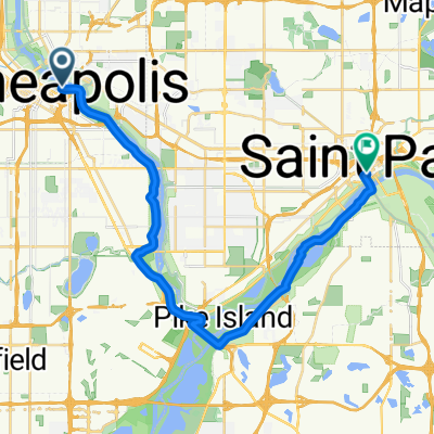
Modello di percorso
Da Minneapolis a Saint Paul

- 1 h 27 min
- Durata
- 25,5 km
- Distanza
- 201 m
- Salita
- 227 m
- Discesa
- 17,6 km/h
- Velocità media
- 259 m
- Altitudine max.
Get ready for a scenic and super smooth ride from Minneapolis to Saint Paul! This nearly 25.5 km route is almost entirely on dedicated cycleways, so you can relax and enjoy the trip without worrying about cars. With 99% paved surfaces (most of them asphalt), it's perfect for all bike types.
You’ll start in downtown Minneapolis, famous for its vibrant arts scene and beautiful riverfront parks. Riding east, you'll follow paths that often hug the Mississippi River, offering great views and plenty of spots to stop for a break. Don't be surprised if you pass locals jogging or kayaking along the way!
The slight uphill (about 200 meters ascent) is manageable for most riders, and the gentle descent into Saint Paul is a nice reward. When you arrive, you’ll find yourself in Minnesota’s charming capital, known for its historic architecture and cozy cafes. All in all, it's a gorgeous urban ride connecting the Twin Cities in the best way possible—on two wheels!
Community
Utenti migliori in questa regione


Dalla nostra comunità
I migliori percorsi in bici da Minneapolis a Saint Paul

Mississippi River Trail
Percorso ciclabile a Minneapolis, Minnesota, Stati Uniti
- 47,3 km
- Distanza
- 247 m
- Salita
- 245 m
- Discesa

B2B00309 55401>55101 via University Av, Transitway, Como Ave
Percorso ciclabile a Minneapolis, Minnesota, Stati Uniti
- 17,7 km
- Distanza
- 106 m
- Salita
- 105 m
- Discesa

B2B00865 55405>55102 via Greenway, Summit Av
Percorso ciclabile a Minneapolis, Minnesota, Stati Uniti
- 19,9 km
- Distanza
- 76 m
- Salita
- 76 m
- Discesa

B2B00204 55413>55102 via University & Como Ave
Percorso ciclabile a Minneapolis, Minnesota, Stati Uniti
- 16,8 km
- Distanza
- 83 m
- Salita
- 103 m
- Discesa

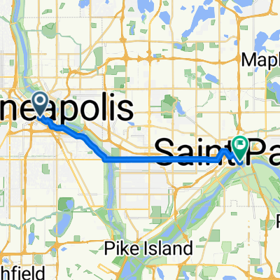
St. Paul
Percorso ciclabile a Minneapolis, Minnesota, Stati Uniti
- 26,2 km
- Distanza
- 168 m
- Salita
- 172 m
- Discesa

home ride
Percorso ciclabile a Minneapolis, Minnesota, Stati Uniti
- 16,6 km
- Distanza
- 115 m
- Salita
- 149 m
- Discesa

B2B 55413 > 55101 via East River Rd., Summit Ave.
Percorso ciclabile a Minneapolis, Minnesota, Stati Uniti
- 19,2 km
- Distanza
- 126 m
- Salita
- 134 m
- Discesa

B2B00083 55403 > 55102 via Nicollet, Midtown Greenway, W. River Road, Lake/Marshall, Summit, Kellog Blvd., 7th St. W.
Percorso ciclabile a Minneapolis, Minnesota, Stati Uniti
- 18,1 km
- Distanza
- 44 m
- Salita
- 52 m
- Discesa

B2B00762 55413>55101 via 8th St SE, Como Av
Percorso ciclabile a Minneapolis, Minnesota, Stati Uniti
- 17,2 km
- Distanza
- 53 m
- Salita
- 46 m
- Discesa

B2B00267 55401>55101via Hiawatha Trl, Greenway and Marshall Ave
Percorso ciclabile a Minneapolis, Minnesota, Stati Uniti
- 16,3 km
- Distanza
- 55 m
- Salita
- 37 m
- Discesa

B2B00761 55413>55102 via 8th Av SE, Como Av, Cedar St
Percorso ciclabile a Minneapolis, Minnesota, Stati Uniti
- 17,6 km
- Distanza
- 51 m
- Salita
- 61 m
- Discesa

B2B00881 55407>55102 via Greenway, Summit Av
Percorso ciclabile a Minneapolis, Minnesota, Stati Uniti
- 15,2 km
- Distanza
- 65 m
- Salita
- 77 m
- Discesa
Scopri più percorsi
 St. Paul
- Distanza
- 26,2 km
- Salita
- 168 m
- Discesa
- 172 m
- Posizione
- Minneapolis, Minnesota, Stati Uniti
 home ride
- Distanza
- 16,6 km
- Salita
- 115 m
- Discesa
- 149 m
- Posizione
- Minneapolis, Minnesota, Stati Uniti
 B2B 55413 > 55101 via East River Rd., Summit Ave.
- Distanza
- 19,2 km
- Salita
- 126 m
- Discesa
- 134 m
- Posizione
- Minneapolis, Minnesota, Stati Uniti
 B2B00083 55403 > 55102 via Nicollet, Midtown Greenway, W. River Road, Lake/Marshall, Summit, Kellog Blvd., 7th St. W.
- Distanza
- 18,1 km
- Salita
- 44 m
- Discesa
- 52 m
- Posizione
- Minneapolis, Minnesota, Stati Uniti
 B2B00762 55413>55101 via 8th St SE, Como Av
- Distanza
- 17,2 km
- Salita
- 53 m
- Discesa
- 46 m
- Posizione
- Minneapolis, Minnesota, Stati Uniti
 B2B00267 55401>55101via Hiawatha Trl, Greenway and Marshall Ave
- Distanza
- 16,3 km
- Salita
- 55 m
- Discesa
- 37 m
- Posizione
- Minneapolis, Minnesota, Stati Uniti
 B2B00761 55413>55102 via 8th Av SE, Como Av, Cedar St
- Distanza
- 17,6 km
- Salita
- 51 m
- Discesa
- 61 m
- Posizione
- Minneapolis, Minnesota, Stati Uniti
 B2B00881 55407>55102 via Greenway, Summit Av
- Distanza
- 15,2 km
- Salita
- 65 m
- Discesa
- 77 m
- Posizione
- Minneapolis, Minnesota, Stati Uniti
Percorsi da Minneapolis
Gita in bici di un giorno da
Da Minneapolis a Richfield
Gita in bici di un giorno da
Da Minneapolis a Mendota Heights
Giro veloce in bici da
Da Minneapolis a Saint Anthony
Giro veloce in bici da
Da Minneapolis a Lauderdale
Percorsi verso Saint Paul
Giro veloce in bici da
Da Falcon Heights a Saint Paul