

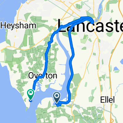
Day 8, 37 hilly miles from Lancaster to Tockholes
Un percorso ciclabile con partenza da Galgate, Inghilterra, Regno Unito.
Panoramica
Su questo percorso
September 8, 2008. Today we started a half hour earlier than normal (8:00 instead of 8:30). It was a glorious day and we had not realized how pastorally "green and pleasant" is northern Lancashire just a few miles from the (former) dark satanic mills of Preston, Blackburn, Manchester, Liverpool and the dozens of factory towns in between. We turned east off the A6 at Galgate and took back roads through Oakenclough, Inglewhite, and Longridge (where we had coffee at a stylish cafe-wine bar internally integrated, we discovered on entering, with a hair salon. This was actually a short day of cycling - 37 miles in linear distance but about 4,000 feet in accumulated vertical assent. Half way to Blackburn we celebrated our "Everest moment" when the trip accumulated assent reached 29,028 feet. We began to wonder whether the line from the Beatles song was actually "there are 4,000 hills in Blackburn, Lancashire" but we eventually emerged into the rural road to Tockholes, where Charles I hid in a tree from Cromwell's army. Our cycling day ended with a relaxed late lunch at the canine-filled Royal Arms. Our hotel was The Lion, an old and quite large hotel on the High Street, of Shrewsbury.
- -:--
- Durata
- 58,4 km
- Distanza
- 660 m
- Salita
- 458 m
- Discesa
- ---
- Velocità media
- 258 m
- Altitudine max.

Foto del percorso


Qualità del percorso
Tipi di percorsi e superfici lungo il percorso
Tipi di percorso
Strada
24,9 km
(43 %)
Strada trafficata
20,7 km
(35 %)
Superfici
Asfaltato
18,5 km
(32 %)
Asfalto
17,2 km
(30 %)
Pavimentato (non definito)
1,2 km
(2 %)
Non definito
40 km
(68 %)
Continua con Bikemap
Usa, modifica o scarica questo percorso ciclabile
Vuoi percorrere Day 8, 37 hilly miles from Lancaster to Tockholes o personalizzarlo per il tuo viaggio? Ecco cosa puoi fare con questo percorso su Bikemap:
Funzionalità gratuite
- Salva questo percorso tra i preferiti o in una raccolta
- Copia e pianifica la tua versione di questo percorso
- Sincronizza il tuo percorso con Garmin o Wahoo
Funzionalità Premium
Prova gratuita di 3 giorni o pagamento una tantum. Scopri di più su Bikemap Premium.
- Naviga questo percorso su iOS e Android
- Esporta un file GPX / KML di questo percorso
- Crea la tua stampa personalizzata (provala gratis)
- Scarica questo percorso per la navigazione offline
Scopri altre funzionalità Premium.
Ottieni Bikemap PremiumDalla nostra community
Galgate: Altri percorsi popolari che iniziano qui
 Glasson Dock to Grasmere
- Distanza
- 83,6 km
- Salita
- 463 m
- Discesa
- 397 m
- Posizione
- Galgate, Inghilterra, Regno Unito
 bowland off orad evening/weekend-henry
- Distanza
- 27,6 km
- Salita
- 708 m
- Discesa
- 713 m
- Posizione
- Galgate, Inghilterra, Regno Unito
 Glasson Marina to Sunderland Point
- Distanza
- 19,6 km
- Salita
- 67 m
- Discesa
- 65 m
- Posizione
- Galgate, Inghilterra, Regno Unito
 Route from Hillam Lane, Cockerham, Lancaster
- Distanza
- 19,8 km
- Salita
- 10 m
- Discesa
- 12 m
- Posizione
- Galgate, Inghilterra, Regno Unito
 Fast ride in Lancaster
- Distanza
- 27,7 km
- Salita
- 68 m
- Discesa
- 66 m
- Posizione
- Galgate, Inghilterra, Regno Unito
 Day 8, 37 hilly miles from Lancaster to Tockholes
- Distanza
- 58,4 km
- Salita
- 660 m
- Discesa
- 458 m
- Posizione
- Galgate, Inghilterra, Regno Unito
 caton short
- Distanza
- 25,4 km
- Salita
- 178 m
- Discesa
- 177 m
- Posizione
- Galgate, Inghilterra, Regno Unito
 Day 8 - Lancaster to Broughton-in-Furness
- Distanza
- 110,9 km
- Salita
- 1.005 m
- Discesa
- 1.051 m
- Posizione
- Galgate, Inghilterra, Regno Unito
Aprila nell’app