

Сarpathian peaks. Route 2.
Un percorso ciclabile con partenza da Tatariv, oblast' di Ivano-Frankivs'k, Ucraina.
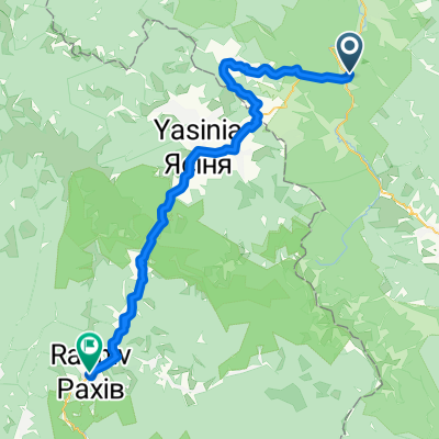
Panoramica
Su questo percorso
· Cascata Huk. Quasi ogni terza cascata nei Carpazi si chiama Huk (può essere tradotto come "rumoroso"). Chiamiamo quindi questa in particolare situata a diversi km da Mykulychyn Huk Zhenetskyi, poiché questa turbolenta cascata alta 15 m si trova sul fiume Zhenets.
· Ponte ferroviario ad arco (viadotto). Uno dei ponti ad arco in pietra più antichi e lunghi d’Europa si trova a Vorokhta (130 m) e la lunghezza di uno degli archi è di 65 m. Questo famoso ponte ferroviario è stato costruito nel 1894 e ha funzionato fino al 2000. A Vorokhta si trova anche una delle più antiche chiese in legno del XVII secolo – la chiesa della Natività della Vergine preservata.
· Passo di Yablunytskyi (passo Tatarsky) – 931 m sul livello del mare. Qui visiterai il mercato dei souvenir noto non solo nei Carpazi ma in tutta l’Ucraina. A Tatariv ci fermeremo al monumento del periodo della Prima Guerra Mondiale.
- -:--
- Durata
- 60,1 km
- Distanza
- 621 m
- Salita
- 621 m
- Discesa
- ---
- Velocità media
- ---
- Altitudine max.

Punti salienti del percorso
Punti di interesse lungo il percorso

Punto di interesse dopo 10,4 km
Waterfall Huk (may be translated as “loud”) is turbulent 15m-high waterfall situated on the Zhenets river at an altitude 900 m above sea level. Due to constant moisture and breezes from waterfall, vegetation here is very diverse.

Punto di interesse dopo 24,6 km
• Railway arched bridge (viaduct). One of the oldest and the longest stone arched bridges of Europe is situated in Vorokhta (130 m) and the length of one of the arches is 65 m. This famous railway bridge was built in 1894 and operated till 2000.

Punto di interesse dopo 37,5 km
Yablonitsky Pass is a pass through the Carpathian Mountains in Ukraine, located in the south-eastern part of Ivano-Frankivsk Oblast. It is one of several passes connecting Transcarpathia with the rest of the country. The headwaters of the Prut River are in the northern end of this pass, and its southern end is part of the Tisza River valley. Here you can visit the souvenir market known not only in the Carpathians but in the whole Ukraine.
Continua con Bikemap
Usa, modifica o scarica questo percorso ciclabile
Vuoi percorrere Сarpathian peaks. Route 2. o personalizzarlo per il tuo viaggio? Ecco cosa puoi fare con questo percorso su Bikemap:
Funzionalità gratuite
- Salva questo percorso tra i preferiti o in una raccolta
- Copia e pianifica la tua versione di questo percorso
- Sincronizza il tuo percorso con Garmin o Wahoo
Funzionalità Premium
Prova gratuita di 3 giorni o pagamento una tantum. Scopri di più su Bikemap Premium.
- Naviga questo percorso su iOS e Android
- Esporta un file GPX / KML di questo percorso
- Crea la tua stampa personalizzata (provala gratis)
- Scarica questo percorso per la navigazione offline
Scopri altre funzionalità Premium.
Ottieni Bikemap PremiumDalla nostra community
Tatariv: Altri percorsi popolari che iniziano qui
 Татарів - Микуличин - Космач - Шепіт - Білоберізка
- Distanza
- 86,2 km
- Salita
- 1.640 m
- Discesa
- 1.869 m
- Posizione
- Tatariv, oblast' di Ivano-Frankivs'k, Ucraina
 Сarpathian peaks. Route 2.
- Distanza
- 60,1 km
- Salita
- 621 m
- Discesa
- 621 m
- Posizione
- Tatariv, oblast' di Ivano-Frankivs'k, Ucraina
 Водопад Жанецкий Гук - Буковель
- Distanza
- 48,2 km
- Salita
- 638 m
- Discesa
- 636 m
- Posizione
- Tatariv, oblast' di Ivano-Frankivs'k, Ucraina
 Khomiak by bike
- Distanza
- 38,6 km
- Salita
- 1.778 m
- Discesa
- 1.944 m
- Posizione
- Tatariv, oblast' di Ivano-Frankivs'k, Ucraina
 Carpathian Peaks. Route 1.
- Distanza
- 26,4 km
- Salita
- 368 m
- Discesa
- 369 m
- Posizione
- Tatariv, oblast' di Ivano-Frankivs'k, Ucraina
 Carpathian peaks. Mt.Lisniv - Mykulychyn
- Distanza
- 41,7 km
- Salita
- 855 m
- Discesa
- 1.501 m
- Posizione
- Tatariv, oblast' di Ivano-Frankivs'k, Ucraina
 Пшк 2012-08-18 Микулич-Космач 40км
- Distanza
- 39,8 km
- Salita
- 1.067 m
- Discesa
- 1.040 m
- Posizione
- Tatariv, oblast' di Ivano-Frankivs'k, Ucraina
 Татарів-Буковель-Рахів
- Distanza
- 68,5 km
- Salita
- 508 m
- Discesa
- 749 m
- Posizione
- Tatariv, oblast' di Ivano-Frankivs'k, Ucraina
Aprila nell’app