
Hiking 120 Miles Alone on the Tour Du Mont Blanc Loop
Un percorso ciclabile con partenza da Martigny-Combe, Canton Vallese, Svizzera.
Panoramica
Su questo percorso
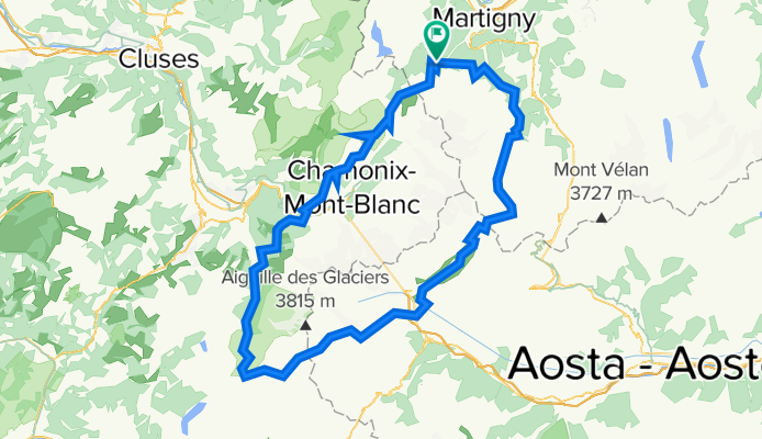
Il Tour du Mont Blanc è un anello di 120 miglia che circonda il massiccio del Mont Blanc e attraversa le Alpi svizzere, francesi e italiane. Ogni sezione del percorso in ogni paese ha la sua personalità. Il sentiero è ben mantenuto e punteggiato da colorati segnavia 'TMB'. Troverai molte altre persone su questo sentiero, tutte in cammino per motivi diversi. È solitamente impossibile capire da quanto tempo qualcuno sta camminando perché il sentiero è un anello senza un vero punto di partenza o di arrivo. Incontrerai trekker con zaini grandi che percorrono l'intero anello, escursionisti giornalieri, turisti in funivia, corridori su sentiero, ciclisti fuoristrada, famiglie con cani e locali che fanno la loro passeggiata mattutina. Passerai per piccoli villaggi nascosti tra le montagne e grandi città vivaci piene di turisti. Il sentiero è punteggiato di Rifugi e campeggi dove puoi mangiare, bere e dormire. Il sentiero è sicuro, pieno di persone pronte ad aiutarti se necessario, e molto sviluppato, quindi chiunque sia in buona salute e vada al proprio ritmo può completare l'intero anello. Raccomando il Tour du Mont Blanc a chiunque tenti la sua prima escursione di oltre 100 miglia per la sua bellezza, difficoltà moderata e basso rischio. Anche se questo è un sentiero molto popolare e frequentato in Europa, puoi comunque trovare momenti di tranquilla solitudine tra i paesi e sui passi di montagna lontano da strade o funivie.
- -:--
- Durata
- 165,3 km
- Distanza
- 12.832 m
- Salita
- 12.837 m
- Discesa
- ---
- Velocità media
- 2.663 m
- Altitudine max.

Continua con Bikemap
Usa, modifica o scarica questo percorso ciclabile
Vuoi percorrere Hiking 120 Miles Alone on the Tour Du Mont Blanc Loop o personalizzarlo per il tuo viaggio? Ecco cosa puoi fare con questo percorso su Bikemap:
Funzionalità gratuite
- Salva questo percorso tra i preferiti o in una raccolta
- Copia e pianifica la tua versione di questo percorso
- Dividilo in tappe per creare un tour di più giorni
- Sincronizza il tuo percorso con Garmin o Wahoo
Funzionalità Premium
Prova gratuita di 3 giorni o pagamento una tantum. Scopri di più su Bikemap Premium.
- Naviga questo percorso su iOS e Android
- Esporta un file GPX / KML di questo percorso
- Crea la tua stampa personalizzata (provala gratis)
- Scarica questo percorso per la navigazione offline
Scopri altre funzionalità Premium.
Ottieni Bikemap PremiumDalla nostra community
Martigny-Combe: Altri percorsi popolari che iniziano qui
 Route de la Forclaz, Martigny-Croix nach Chemin du Glacier de Taconnaz, Chamonix-Mont-Blanc
- Distanza
- 35,6 km
- Salita
- 658 m
- Discesa
- 964 m
- Posizione
- Martigny-Combe, Canton Vallese, Svizzera
 MontBlancTour5Tag
- Distanza
- 14 km
- Salita
- 1.107 m
- Discesa
- 935 m
- Posizione
- Martigny-Combe, Canton Vallese, Svizzera
 Hiking 120 Miles Alone on the Tour Du Mont Blanc Loop
- Distanza
- 165,3 km
- Salita
- 12.832 m
- Discesa
- 12.837 m
- Posizione
- Martigny-Combe, Canton Vallese, Svizzera
 Startup Route des Grandes Alpes
- Distanza
- 40 km
- Salita
- 1.360 m
- Discesa
- 834 m
- Posizione
- Martigny-Combe, Canton Vallese, Svizzera
 Trevor Flat big loop
- Distanza
- 73,5 km
- Salita
- 303 m
- Discesa
- 303 m
- Posizione
- Martigny-Combe, Canton Vallese, Svizzera
 Trevor - Champex lac loop
- Distanza
- 42,5 km
- Salita
- 1.099 m
- Discesa
- 1.099 m
- Posizione
- Martigny-Combe, Canton Vallese, Svizzera
 Trevor - Champex and Planche
- Distanza
- 51,3 km
- Salita
- 1.740 m
- Discesa
- 1.740 m
- Posizione
- Martigny-Combe, Canton Vallese, Svizzera
 La Chatelard-Lac de Emosson
- Distanza
- 18,3 km
- Salita
- 1.556 m
- Discesa
- 838 m
- Posizione
- Martigny-Combe, Canton Vallese, Svizzera
Aprila nell’app