

B-D 15. Sankt Veit an der Glan to Bled
Un percorso ciclabile con partenza da Sankt Veit an der Glan, Carinzia, Austria.
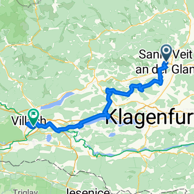
Panoramica
Su questo percorso
52.5km/160m↑ to train at Villach to Jesenice, + 16.4km/240m↑ to Bled Dep: 1253
Train stations: Sankt Veit; Liebenfels; Tauchendorf; Glanegg; Mautbrücken; St.Martin; Feldkirchen; Tiffen; Steindorf; Ossiach; St.Urban; Sattendorf; Annenheim; Villach St.Ruprecht; Villach Landskron; Villach; Jesenice
- -:--
- Durata
- 141 km
- Distanza
- 1.594 m
- Salita
- 1.597 m
- Discesa
- ---
- Velocità media
- 861 m
- Altitudine max.

Qualità del percorso
Tipi di percorsi e superfici lungo il percorso
Tipi di percorso
Pista ciclabile
57,8 km
(41 %)
Strada tranquilla
32,4 km
(23 %)
Superfici
Asfaltato
110 km
(78 %)
Non asfaltato
15,5 km
(11 %)
Asfalto
87,4 km
(62 %)
Pavimentato (non definito)
22,6 km
(16 %)
Punti salienti del percorso
Punti di interesse lungo il percorso
Alloggio dopo 0 km
Hotel Bellini
Alloggio dopo 0 km
Gasthof Eberhard - Hof, Wirtshaus & Herberge
Alloggio dopo 0 km
Hotel Fuchspalast
Punto di interesse dopo 18,2 km
Burgruine Glanegg
Punto di interesse dopo 31,6 km
Fish ladder that was built as part of the construction of the Bleistätter Moor. The Tiebel river was also dredged from here to the state road further west. Originally there was a 1.5m high concrete sill over which the water tumbled down. On the east side of the fish ladder you can still see the remains of it, the old threshold was only partially removed and is integrated into the new fish ladder. There is also a level measuring station from the province of Carinthia, the facilities for this are housed in a small wooden hut on the east side of the fish ladder. For the construction of the fish ladder, a bypass channel was dug in the field behind, of which of course nothing is visible anymore. The staircase consists of several tiered pools made of natural stone, where the differences in height are designed in such a way that fish can swim or jump to overcome this difference in height and thus migrate between the higher and the lower part of the river. In the pools there are also areas with a low flow rate, where the fish can rest after the individual jumps. After the fish ladder downstream you can see 3 bright bands. These are concrete strips that are intended to keep the sole of the foot stable in terms of height and at least greatly reduce washouts (scour). The whole thing has been very sensitively embedded in the river and the surrounding landscape, now it has become a beautiful place to stay and observe nature.
Punto di interesse dopo 35,3 km
Steindorfer Moorturm Observation deck
Punto di interesse dopo 35,7 km
Domenig Steinhaus closed Monday
Punto di interesse dopo 45,4 km
Ossiacher See viewpoint Ossiacher See Aussichtsplattform
Punto di interesse dopo 47,2 km
Burg Landskron
Punto di interesse dopo 52,5 km
Train Villach to Jesenice (SL) 1253-1329 Express train 211 dir Vinkovci Platform D-E Coach 402 Seats 73-76 Bikes Coach 403 Spaces 13-16 [luggage first & then bikes] Dep: 0625, 0835, 1253, 1653, 1853 34-44 min € 9.70 + € 3
Punto di interesse dopo 133,7 km
Vintgar Gorge Entry fee. Ridiculously beautiful walk along the river showing nature at her best with running water, waterfalls, moss, a variety of flowers and clean fresh air. The walk is fairly easy and not far. Worth noting however that it is a one way trip and that you are either going to do a 45 minute moderate walk back (which is also gorgeous as the path we took had views of the city Bled and fields of cows) or you are going to pay for a taxi. Best come prepared for a longer hike.
Punto di interesse dopo 138,1 km
Bled Castle Blejski grad 0800-2000 11th century clifftop castle overlooking Lake Bled with a museum, restaurant & wine cellar.
Punto di interesse dopo 139,1 km
view point
Punto di interesse dopo 139,5 km
Must try Bled Kremšnita cream cake!
Punto di interesse dopo 139,8 km
Hire pletna to row across to island, or : Boat departures to Island: 10.00, 11.00, 12.00, 13.00, 14. 00, 15.00 16.00, 17.00, 18.00 Return boat: 11.20, 12.20, 13.20, 14.20, 15.20, 16.20, 17.20, 18.20 19.00 12,00 € per person (2022)
Punto di interesse dopo 140,7 km
Assumption of Maria Church Cerkev Marijinega Vnebovzetja
Punto di interesse dopo 140,9 km
Sunset View Straza
Punto di interesse dopo 140,9 km
Mlino Port for Pletna Boat Mlino pletna pristanišče
Punto di interesse dopo 141 km
For a suburb shot of Bled island, castle and the mountains at the back, climb up a small hill named Ojstrica (it takes around 20 minutes). If you enjoy taking photos of sunrises, get there early and enjoy the view of spectacular colours reflecting in the water.
Punto di interesse dopo 141 km
Photo point
Punto di interesse dopo 141 km
99 Steps Stone Stairway if you rent a row boat the mooring is around the back of the island (opposite side of main steps). You can use a drone here and it’s a great place to feed to the ducks so don’t forget the stale bread. Wonderful coffee and gelato shop and plenty of spots to sit.
Alloggio dopo 141 km
Heritage Hotel Starkl
Continua con Bikemap
Usa, modifica o scarica questo percorso ciclabile
Vuoi percorrere B-D 15. Sankt Veit an der Glan to Bled o personalizzarlo per il tuo viaggio? Ecco cosa puoi fare con questo percorso su Bikemap:
Funzionalità gratuite
- Salva questo percorso tra i preferiti o in una raccolta
- Copia e pianifica la tua versione di questo percorso
- Dividilo in tappe per creare un tour di più giorni
- Sincronizza il tuo percorso con Garmin o Wahoo
Funzionalità Premium
Prova gratuita di 3 giorni o pagamento una tantum. Scopri di più su Bikemap Premium.
- Naviga questo percorso su iOS e Android
- Esporta un file GPX / KML di questo percorso
- Crea la tua stampa personalizzata (provala gratis)
- Scarica questo percorso per la navigazione offline
Scopri altre funzionalità Premium.
Ottieni Bikemap PremiumDalla nostra community
Sankt Veit an der Glan: Altri percorsi popolari che iniziano qui
 St Veit - Wimitz - Sirnitz - Straßburg - St. Veit
- Distanza
- 97,5 km
- Salita
- 2.251 m
- Discesa
- 2.253 m
- Posizione
- Sankt Veit an der Glan, Carinzia, Austria
 RR-Berg: St.Veit-KleinSt.Veit-Haimburg-Diex-Brückl-Diex-Brückl-St.Veit
- Distanza
- 74,9 km
- Salita
- 913 m
- Discesa
- 913 m
- Posizione
- Sankt Veit an der Glan, Carinzia, Austria
 Kleine Scheifling/Taggenbrunnrunde
- Distanza
- 9 km
- Salita
- 218 m
- Discesa
- 220 m
- Posizione
- Sankt Veit an der Glan, Carinzia, Austria
 2x Lorenziberg
- Distanza
- 23,8 km
- Salita
- 875 m
- Discesa
- 875 m
- Posizione
- Sankt Veit an der Glan, Carinzia, Austria
 Ulrichsberg
- Distanza
- 13,9 km
- Salita
- 510 m
- Discesa
- 41 m
- Posizione
- Sankt Veit an der Glan, Carinzia, Austria
 D6_b_S. Vait a G _ Villach
- Distanza
- 75,5 km
- Salita
- 978 m
- Discesa
- 971 m
- Posizione
- Sankt Veit an der Glan, Carinzia, Austria
 St. Veit an der Glan - Brückl - Völkermarkt - Maria Saal - St. Veit an der Glan CLONED FROM ROUTE 275135
- Distanza
- 71,4 km
- Salita
- 507 m
- Discesa
- 505 m
- Posizione
- Sankt Veit an der Glan, Carinzia, Austria
 UNSER LAND St. Veit - Villach
- Distanza
- 54,9 km
- Salita
- 207 m
- Discesa
- 189 m
- Posizione
- Sankt Veit an der Glan, Carinzia, Austria
Aprila nell’app