

Moab to Mineral Bottom Road
Un percorso ciclabile con partenza da Moab, Utah, Stati Uniti.
Panoramica
Su questo percorso
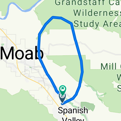
La strada da Moab a Mineral Bottom è un percorso sicuro e divertente che segue la pista ciclabile fino alla strada 313.
La pista ciclabile, che si trova appena a nord di Moab sul lato nord del fiume Colorado, è nuova e in ottime condizioni. Si segue il percorso oltre l'ingresso del Parco Nazionale Arches e su per la collina che esce dalla valle di Moab. Questa collina raggiunge una pendenza di circa il 6% e allontana i ciclisti dall'auto trafficata. Dopo alcuni chilometri, il percorso torna verso ovest, passa sotto la strada (US191) e continua oltre la Gemini Bridges Road fino alla Utah 313.
A questo punto, si attraversa la strada e si dirige verso ovest, curvando lentamente verso sud, su una strada ampia con una buona spalla. Anche se la 313 va al Dead Horse State Park e al Canyonlands National Park, non è molto trafficata. La segui attraverso il Nine Mile Canyon mentre si restringe, poi fai un paio di tornanti più ripidi (7%-8%) per raggiungere le alte pianure vicino a Moab e ai Monitor Buttes. Continua con un terreno ondulato, ma generalmente in salita (con una pendenza molto bassa). La Mineral Bottom Road è a 23 miglia. Arriva lì e torna indietro.
Dovresti farlo quando c'è poco vento... soffia forte sopra i tornanti sulla 313. Porta molta acqua poiché non ci sono strutture. La distanza totale è di 46 miglia con circa 2300 piedi di dislivello. Se sei solo in visita e non hai una bicicletta, Poison Spider Bicycles al nord di Moab (sulla 191) ha ottime biciclette da strada a noleggio.
- -:--
- Durata
- 75,4 km
- Distanza
- 688 m
- Salita
- 690 m
- Discesa
- ---
- Velocità media
- ---
- Altitudine max.
Continua con Bikemap
Usa, modifica o scarica questo percorso ciclabile
Vuoi percorrere Moab to Mineral Bottom Road o personalizzarlo per il tuo viaggio? Ecco cosa puoi fare con questo percorso su Bikemap:
Funzionalità gratuite
- Salva questo percorso tra i preferiti o in una raccolta
- Copia e pianifica la tua versione di questo percorso
- Sincronizza il tuo percorso con Garmin o Wahoo
Funzionalità Premium
Prova gratuita di 3 giorni o pagamento una tantum. Scopri di più su Bikemap Premium.
- Naviga questo percorso su iOS e Android
- Esporta un file GPX / KML di questo percorso
- Crea la tua stampa personalizzata (provala gratis)
- Scarica questo percorso per la navigazione offline
Scopri altre funzionalità Premium.
Ottieni Bikemap PremiumDalla nostra community
Moab: Altri percorsi popolari che iniziano qui
 Moab through Arches and Back
- Distanza
- 69,8 km
- Salita
- 1.017 m
- Discesa
- 1.024 m
- Posizione
- Moab, Utah, Stati Uniti
 Potash Road
- Distanza
- 68,6 km
- Salita
- 685 m
- Discesa
- 688 m
- Posizione
- Moab, Utah, Stati Uniti
 USA_2016_Arches-Bryce Canyon-Las Vegas
- Distanza
- 924,4 km
- Salita
- 3.861 m
- Discesa
- 4.733 m
- Posizione
- Moab, Utah, Stati Uniti
 Moab - A Pretty Flat Route to Potash
- Distanza
- 66,2 km
- Salita
- 1.097 m
- Discesa
- 1.092 m
- Posizione
- Moab, Utah, Stati Uniti
 Portal Long Canyon Mag7 Portal
- Distanza
- 72,7 km
- Salita
- 1.754 m
- Discesa
- 1.750 m
- Posizione
- Moab, Utah, Stati Uniti
 Moab
Moab- Distanza
- 17,3 km
- Salita
- 691 m
- Discesa
- 708 m
- Posizione
- Moab, Utah, Stati Uniti
 Porcupine Rim Trail
- Distanza
- 22,9 km
- Salita
- 529 m
- Discesa
- 1.054 m
- Posizione
- Moab, Utah, Stati Uniti
 Moab Gran Fondo Loop
- Distanza
- 94,5 km
- Salita
- 1.824 m
- Discesa
- 1.675 m
- Posizione
- Moab, Utah, Stati Uniti
Aprila nell’app