

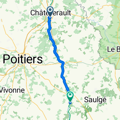
DAY ONE Châtellerault - Savigny-sous-Faye
Un percorso ciclabile con partenza da Châtellerault, Aquitania-Limosino-Poitou-Charentes, Francia.
Panoramica
Su questo percorso
Primo Giorno
Stazione di Châtellerault - Camping Municipal Les Iris, Savigny-sous-Faye
Il percorso inizia a Châtellerault nel dipartimento della Vienne, nella Nuova Aquitania. Dopo un treno TER mattutino, Châtellerault offre tempo per una colazione e una breve visita della città prima di cercare l'inizio della Ligne Verte. Châtellerault ha collegamenti con la Scozia, infatti, in cambio dei servizi offerti alle Corone di Scozia e Francia, il titolo di Duc de Châtellerault (1548) fu conferito a James Hamilton, 2° Conte di Arran, Capo del Nome e reggente di Scozia durante l'infanzia di Maria, Regina di Scozia e di Francia. Tuttavia, si rivolse contro la Regina nel 1559, e le sue proprietà e il titolo francesi furono confiscati. Questo periodo della storia scozzese può essere ricordato ancora oggi nel nome del villaggio di Chatelherault nel North Lanarkshire, Scozia – vicino a dove il Duca di Hamilton aveva un tempo un palazzo molto grande e vicino a dove vivo. L'ortografia, per ragioni sconosciute (forse per scrittura o errore), non è esattamente quella della città in Francia. La Ligne Verte è una vecchia linea ferroviaria convertita in pista ciclabile e sentieri che va da Châtellerault a Loudun, passando per l'area di Lencloître. Questo percorso ciclabile è noto localmente come Voie Sylvain Chavane. Sylvain Chavane, nato a Châtellerault, è stato un corridore professionista francese su strada tra il 2000 e il 2018. L'inizio della ligne verte si raggiunge dal lato est del Pont Henri IV, quindi attraversando il fiume Vienne e percorrendo una breve tratta in bicicletta attraverso alcune strade della città.
Questa prima tappa del percorso termina in un campeggio a Savigny-sous-Faye.
Camping Municipal Les Iris
4 rue du Lavior, 86140 Savigny-sous-Faye
FRANCIA
Tel: +33 5 49 90 70 59
Cellulare: +33 7 71 87 04 09
- 1 h 26 min
- Durata
- 24,5 km
- Distanza
- 138 m
- Salita
- 79 m
- Discesa
- 17,1 km/h
- Velocità media
- 114 m
- Altitudine max.

Qualità del percorso
Tipi di percorsi e superfici lungo il percorso
Tipi di percorso
Pista ciclabile
21 km
(86 %)
Strada tranquilla
1,5 km
(6 %)
Superfici
Asfaltato
21 km
(86 %)
Asfalto
21 km
(86 %)
Non definito
3,4 km
(14 %)
Continua con Bikemap
Usa, modifica o scarica questo percorso ciclabile
Vuoi percorrere DAY ONE Châtellerault - Savigny-sous-Faye o personalizzarlo per il tuo viaggio? Ecco cosa puoi fare con questo percorso su Bikemap:
Funzionalità gratuite
- Salva questo percorso tra i preferiti o in una raccolta
- Copia e pianifica la tua versione di questo percorso
- Sincronizza il tuo percorso con Garmin o Wahoo
Funzionalità Premium
Prova gratuita di 3 giorni o pagamento una tantum. Scopri di più su Bikemap Premium.
- Naviga questo percorso su iOS e Android
- Esporta un file GPX / KML di questo percorso
- Crea la tua stampa personalizzata (provala gratis)
- Scarica questo percorso per la navigazione offline
Scopri altre funzionalità Premium.
Ottieni Bikemap PremiumDalla nostra community
Châtellerault: Altri percorsi popolari che iniziano qui
 tour du clain
- Distanza
- 42 km
- Salita
- 231 m
- Discesa
- 231 m
- Posizione
- Châtellerault, Aquitania-Limosino-Poitou-Charentes, Francia
 Chatellerault - Lussac Les Châteaux (60 km) - Chabanais (71 km)
- Distanza
- 131 km
- Salita
- 1.044 m
- Discesa
- 939 m
- Posizione
- Châtellerault, Aquitania-Limosino-Poitou-Charentes, Francia
 Voyage de fouuuuuuuuuuu
- Distanza
- 396,1 km
- Salita
- 2.362 m
- Discesa
- 2.362 m
- Posizione
- Châtellerault, Aquitania-Limosino-Poitou-Charentes, Francia
 11 Tag Châtellerault - Niort
- Distanza
- 112,6 km
- Salita
- 350 m
- Discesa
- 379 m
- Posizione
- Châtellerault, Aquitania-Limosino-Poitou-Charentes, Francia
 Chemin du Chilloux d'Ozon 17B to Rue des Glycines
- Distanza
- 60,1 km
- Salita
- 272 m
- Discesa
- 240 m
- Posizione
- Châtellerault, Aquitania-Limosino-Poitou-Charentes, Francia
 DAY ONE Châtellerault - Savigny-sous-Faye
- Distanza
- 24,5 km
- Salita
- 138 m
- Discesa
- 79 m
- Posizione
- Châtellerault, Aquitania-Limosino-Poitou-Charentes, Francia
 dag 5 chatelleraut naar nabij Savigne
- Distanza
- 92,5 km
- Salita
- 601 m
- Discesa
- 537 m
- Posizione
- Châtellerault, Aquitania-Limosino-Poitou-Charentes, Francia
 SityTrail - 001C Chatellerault St Jacques to St Savin via Angles and En Lo
- Distanza
- 61,2 km
- Salita
- 490 m
- Discesa
- 462 m
- Posizione
- Châtellerault, Aquitania-Limosino-Poitou-Charentes, Francia
Aprila nell’app