

DAY SIX Caen - Ouistreham
Un percorso ciclabile con partenza da Caen, Normandia, Francia.
Panoramica
Su questo percorso
Day Six
Gare de Caen - Hotel L'Ecailler, Ouistreham
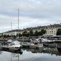
An easy 15km bike ride along an established voie verte or greenway route links Caen town centre to the ferry port in Ouistreham, providing easy access to Portsmouth, England. The voie verte runs alongside the Canal de Caen à la Mer, which in turn runs parallel to the River Orne. The canal is one of France's best established, having been started in 1837, with the thoroughfare opening to boats 20 years later. The canal has two locks, the one near the port at Ouistreham is large enough to allow ships of more than 200m through. There are many key sites to see along the route and near Ouistreham, of the World War II, D-Day landings. The Pegasus Bridge, which crosses the canal near Bénouville is another significant site in World War Two history, having been named after an Allied operation in the opening hours of the Normsndy landings. Britain's 6th Airborne Division was ordered to take and hold the bridge to limit the success of German efforts to make inroads into Allied-held territory. Pegasus was on the shoulder emblem of that division. The bridge seen today, however, is not the original, but a reconstruction; the original is now in the Mémorial Pegasus Musée nearby. Sword Beach, a little west of Ouistreham, is also worth exploring. It was one of three British-Canadian landing areas. The beach represents the eastern flank of the Allied amphibious attack in Normandy. There is so many sites to see it would take several days to do them all justice. Brittany Ferries operates the service to / from Portsmouth and there are various travel times depending on the date and season. There is a campsite near the ferry port itself which is open to touring tents in the summer months (July - October). Camping Riva Bella 1 Rue de la Haie Breton, 14150 Ouistreham, FRANCE TEL: +33 2 31 97 12 66 Various hotels in Ouistreham provide another option for those wishing to stay overnight or for a few days. Booking.com
- 1 h 1 min
- Durata
- 15,3 km
- Distanza
- 69 m
- Salita
- 75 m
- Discesa
- 15,1 km/h
- Velocità media
- 10 m
- Altitudine max.

Qualità del percorso
Tipi di percorsi e superfici lungo il percorso
Tipi di percorso
Sentiero
11,7 km
(76 %)
Area pedonale
2 km
(13 %)
Superfici
Asfaltato
14,3 km
(93 %)
Non asfaltato
1,1 km
(7 %)
Asfalto
14,1 km
(92 %)
Ghiaia
1,1 km
(7 %)
Calcestruzzo
0,2 km
(1 %)
Continua con Bikemap
Usa, modifica o scarica questo percorso ciclabile
Vuoi percorrere DAY SIX Caen - Ouistreham o personalizzarlo per il tuo viaggio? Ecco cosa puoi fare con questo percorso su Bikemap:
Funzionalità gratuite
- Salva questo percorso tra i preferiti o in una raccolta
- Copia e pianifica la tua versione di questo percorso
- Sincronizza il tuo percorso con Garmin o Wahoo
Funzionalità Premium
Prova gratuita di 3 giorni o pagamento una tantum. Scopri di più su Bikemap Premium.
- Naviga questo percorso su iOS e Android
- Esporta un file GPX / KML di questo percorso
- Crea la tua stampa personalizzata (provala gratis)
- Scarica questo percorso per la navigazione offline
Scopri altre funzionalità Premium.
Ottieni Bikemap PremiumDalla nostra community
Caen: Altri percorsi popolari che iniziano qui
 caen mont pinson
- Distanza
- 83,9 km
- Salita
- 494 m
- Discesa
- 496 m
- Posizione
- Caen, Normandia, Francia
 Caen - Lion-sur-Mer
- Distanza
- 22,6 km
- Salita
- 53 m
- Discesa
- 59 m
- Posizione
- Caen, Normandia, Francia
 préparation ballade AF3v
- Distanza
- 56,3 km
- Salita
- 156 m
- Discesa
- 145 m
- Posizione
- Caen, Normandia, Francia
 B/F Caen - Le Vey VV Suisse Normandie
- Distanza
- 38,8 km
- Salita
- 276 m
- Discesa
- 257 m
- Posizione
- Caen, Normandia, Francia
 Nomandy BikeTrip
- Distanza
- 123,6 km
- Salita
- 375 m
- Discesa
- 377 m
- Posizione
- Caen, Normandia, Francia
 Caen à D 514, Ranville
- Distanza
- 14,8 km
- Salita
- 46 m
- Discesa
- 63 m
- Posizione
- Caen, Normandia, Francia
 Caen Merville
- Distanza
- 17,5 km
- Salita
- 32 m
- Discesa
- 35 m
- Posizione
- Caen, Normandia, Francia
 Embus'Cat
- Distanza
- 23,3 km
- Salita
- 99 m
- Discesa
- 109 m
- Posizione
- Caen, Normandia, Francia
Aprila nell’app