

st. Andre les Alpes- Montpellier K&L 2011 1/2 CLONED FROM ROUTE 1295811
Un percorso ciclabile con partenza da Annot, Provenza-Alpi-Costa Azzurra, Francia.
Panoramica
Su questo percorso
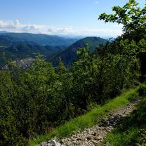
day 1. st. André les Aples- Castellane, Castellane is smal town with lovely atmosphere. Rafting afternoon- great highly recomandet!
day 2. Castellane- Moustiers sainte Marie, going uo and down, marvellous view on canyon, afternoon swimming in the Luc de sainte Croix - a bit muddy
day 3. Moustiers-Cadenet, Moustiers is picturesque town, friendly and shops are open even on sunday. Riez another example of provence town. Alemagne en Provence- village with nice chateau, sundays the is car boot sale, way from Gréoux les Bains to Pont de Mirabeau is not realy nice, actualy it was quite annoying is bussy but was the shortist way, THERE IS A WIND FROM WEST BLOWING IN SEPTEMBER=IT IS STUPID TO GO EAST TO WEST. Pont de Mirabeau is nice. Mirabeau it self is very quiet beautiful place with old church...provence indeed. Peruis is bigger town, lazy and sleapy, ideal for dinner or galss of pastis (if there were any restaurant open -it was sunday, luckyly there are some Arabic restaurants in Pertuis). Cadenet - like smaller Riez, monday there was market in one word: lovely.
Day 4. Cadenet - Saint Martin de Carau, Barben- romantic chateaux and zoological garden. Refreshing change after biking, villages and towns. The way from Barben to Salon de Provence was disaster, bussy and ugly. Salon de Provence- I don't know if it is so unattractive or it was just my impression, but i did not like it at all. Luckily there is a tiny way to Saint Martin de Crau next to the highway, strait flat and fast.
day 5. Saint Martin de Carau - Saintes Maries de la Mer, Arles is noisy and touristic place, but if You are going to Provence it is place You must see. Way across the Camarque should be nice, interesting and exciting, but imho it is not. We have seen all, black bulls, white horses and flamencos but it is little compensation for many kilometers of flat, hot, boring landcape without a single piece of shadow. Saintes Maries de la Mer is classic seaside town. Everithing is for tourist. One thing i found interesting are statues on every roundabout, I tbelive scluptor must be native from Maries, otherwise I do not understand why they would place these funny scluptures allaround. NOTICE THERE ARE MILLIONS OF MOSQUITOS.
day 6. Stes Maries de la Mer - Le Grau du Roi, there is a small ferry on Le Petit Rhone, Aigues Mortes- medieval town, nice but less then those towns in the beginning of the journey, Grau du Roi- lovely port, touristic, bustling an full of live, but may be that was because it was a festival.
day 7. Grau du Roi- Palavas les Flots, Le Grande Motte- interesting place, resort build on a greenfield site in 60th and 70th, homogenous architecture, surely place to see. Palavas les Flots - strange phare compere to rest of town, nice beaches.
day 8. Palavas les Flots- Montpellier, If you want to feel young go to Montpellier!
- -:--
- Durata
- 373,9 km
- Distanza
- 683 m
- Salita
- 1.559 m
- Discesa
- ---
- Velocità media
- ---
- Altitudine max.
Qualità del percorso
Tipi di percorsi e superfici lungo il percorso
Tipi di percorso
Strada trafficata
217,6 km
(58 %)
Strada
49 km
(13 %)
Superfici
Asfaltato
304,5 km
(81 %)
Non asfaltato
3,5 km
(<1 %)
Asfalto
294,5 km
(79 %)
Pavimentato (non definito)
5,3 km
(1 %)
Continua con Bikemap
Usa, modifica o scarica questo percorso ciclabile
Vuoi percorrere st. Andre les Alpes- Montpellier K&L 2011 1/2 CLONED FROM ROUTE 1295811 o personalizzarlo per il tuo viaggio? Ecco cosa puoi fare con questo percorso su Bikemap:
Funzionalità gratuite
- Salva questo percorso tra i preferiti o in una raccolta
- Copia e pianifica la tua versione di questo percorso
- Dividilo in tappe per creare un tour di più giorni
- Sincronizza il tuo percorso con Garmin o Wahoo
Funzionalità Premium
Prova gratuita di 3 giorni o pagamento una tantum. Scopri di più su Bikemap Premium.
- Naviga questo percorso su iOS e Android
- Esporta un file GPX / KML di questo percorso
- Crea la tua stampa personalizzata (provala gratis)
- Scarica questo percorso per la navigazione offline
Scopri altre funzionalità Premium.
Ottieni Bikemap PremiumDalla nostra community
Annot: Altri percorsi popolari che iniziano qui
 Westalpen_13
- Distanza
- 81,6 km
- Salita
- 1.041 m
- Discesa
- 1.465 m
- Posizione
- Annot, Provenza-Alpi-Costa Azzurra, Francia
 Francia- és Provence Alpok, Cote d'Azur 7. nap
- Distanza
- 100 km
- Salita
- 1.611 m
- Discesa
- 1.814 m
- Posizione
- Annot, Provenza-Alpi-Costa Azzurra, Francia
 SAINT AUBAN - ROQUESTERON
- Distanza
- 47,6 km
- Salita
- 706 m
- Discesa
- 1.504 m
- Posizione
- Annot, Provenza-Alpi-Costa Azzurra, Francia
 Col des Champs Vallée du Var
- Distanza
- 105,2 km
- Salita
- 1.968 m
- Discesa
- 1.949 m
- Posizione
- Annot, Provenza-Alpi-Costa Azzurra, Francia
 Saint-Auban - Roquesteron
- Distanza
- 41,4 km
- Salita
- 1.069 m
- Discesa
- 1.805 m
- Posizione
- Annot, Provenza-Alpi-Costa Azzurra, Francia
 Fra - day 8
- Distanza
- 127,6 km
- Salita
- 1.522 m
- Discesa
- 2.138 m
- Posizione
- Annot, Provenza-Alpi-Costa Azzurra, Francia
 Gorge de Verdon to Arles
- Distanza
- 261,6 km
- Salita
- 5.326 m
- Discesa
- 6.205 m
- Posizione
- Annot, Provenza-Alpi-Costa Azzurra, Francia
 De Chemin des Viviers à Chemin des Viviers
- Distanza
- 9 km
- Salita
- 295 m
- Discesa
- 248 m
- Posizione
- Annot, Provenza-Alpi-Costa Azzurra, Francia
Aprila nell’app