

rock gym
- 11,5 km
- 38 m
- 72 m
- Wells Branch, Texas, Stati Uniti
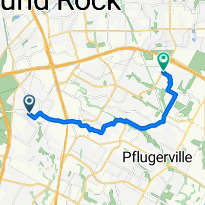
Un percorso ciclabile con partenza da Wells Branch, Texas, Stati Uniti.
Panoramica
Questo è il miglior percorso che ho trovato per andare da Wells Branch al centro. Lo prendo una volta alla settimana e di solito ci vogliono 1,25 ore. Poi prendo l'autobus 935 per tornare a casa.
Il percorso è collinare all'inizio, ma diventa una discesa graduale man mano che ci si avvicina alla città.
Prendi Metric fino a 183. Procedi verso est lungo la strada/il marciapiede della 183 per 0,25 miglia. Passa sotto la 183 all'incrocio di Burnet, nel parcheggio di Chili's. Vai a nord attraverso il parcheggio, lungo la 183, oltre Tabu, BagPipes, fino a McCann Dr.
Fai una bella passeggiata in discesa lungo Shoal Creek fino a W38th Street. Segui i sentieri di Shoal Creek per un paio di isolati fino a quando Shoal Creek Blvd riappare. Prendi Shoal Creek Blvd/W31st fino a N Lamar Blvd.
Prendi N Lamar Blvd verso sud (marciapiede ovest). Alla 15a strada, trova di nuovo il sentiero di Shoal Creek. Questa volta portalo fino alla 5a strada. Ci sono scale alla 15a strada che puoi utilizzare per uscire dal sentiero di Shoal Creek.
Puoi anche prendere il sentiero di Shoal Creek fino alla 3a strada o fino al lago Lady Bird.
creato 16 anni fa
Qualità del percorso
Strada
7 km
(27 %)
Strada tranquilla
2,8 km
(11 %)
Asfaltato
19,6 km
(76 %)
Asfalto
17,5 km
(68 %)
Calcestruzzo
1,8 km
(7 %)
Continua con Bikemap
Vuoi percorrere Wells Branch to Downtown Austin Commute o personalizzarlo per il tuo viaggio? Ecco cosa puoi fare con questo percorso su Bikemap:
Prova gratuita di 3 giorni o pagamento una tantum. Scopri di più su Bikemap Premium.
Scopri altre funzionalità Premium.
Ottieni Bikemap PremiumDalla nostra community
Aprila nell’app


