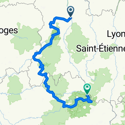
Durch die Auvergne und die Cevennen
- 654,8 km
- 19.759 m
- 19.412 m
- Vichy, Alvernia-Rodano-Alpi, Francia
Un percorso ciclabile con partenza da Vichy, Alvernia-Rodano-Alpi, Francia.
Panoramica
Nonostante le previsioni di pioggia, siamo partiti sotto un cielo per lo più sereno. Non molto tempo dopo, stavamo costeggiando alcune nuvole molto scure che passavano e sentivamo regolarmente tuoni lontani. A circa sette o otto miglia dalla nostra destinazione (l'Etap a Thiers), continuavamo a sperare di non essere sorpresi dalla pioggia.
Addio speranze… siamo stati colpiti dalla grandine (grazie ai caschi, non è stato un grosso problema ma comunque abbastanza rumoroso) e completamente bagnati mentre il forte acquazzone continuava senza tregua per quelle ultime sette o otto miglia. Fortunatamente la signora all'Etap è stata gentile e ci ha indicato di trascinare le nostre biciclette grondanti d'acqua attraverso la hall fino a una stanza sul retro.
Contesto:
Mia moglie ed io facciamo tour in autonomia nell'Europa occidentale (principalmente in Francia) dal 1993. Questa serie di pedalate copre il nostro percorso di 4,5 mesi nel 2009 attraverso parti di Francia, Germania, Austria, Svizzera e poi di ritorno in Francia. Il nostro punto di partenza e arrivo è vicino a Chadurie (a sud di Angoulême) dove i nostri amici hanno una fattoria con Gîtes e Chambres d'Hôtes.
Abbiamo pedalato con le nostre biciclette da turismo Dawes, acquistate nel 1993, cariche di bagagli, con pneumatici 700Cx32. Tutta la nostra pedalata è stata su strade asfaltate, per lo più con poco traffico. Le uniche sezioni non asfaltate erano alcuni sentieri ciclabili in Germania e Austria. Purtroppo non è stato il massimo poiché Helen è caduta più volte sui sentieri non asfaltati. Fortunatamente, nessuna lesione seria.
Per qualsiasi domanda, sentiti libero di scrivermi a jeffkadet@netdiving.com
Jeff
creato 13 anni fa
Qualità del percorso
Strada
14,3 km
(35 %)
Strada tranquilla
3,7 km
(9 %)
Asfaltato
25,8 km
(63 %)
Non asfaltato
0,8 km
(2 %)
Asfalto
25,8 km
(63 %)
Non asfaltato (non definito)
0,8 km
(2 %)
Non definito
14,3 km
(35 %)
Continua con Bikemap
Vuoi percorrere 2009 Euro Tour -- Ride Day 6 — 26 June 2009 — 03200 Vichy to 63300 Thiers o personalizzarlo per il tuo viaggio? Ecco cosa puoi fare con questo percorso su Bikemap:
Prova gratuita di 3 giorni o pagamento una tantum. Scopri di più su Bikemap Premium.
Scopri altre funzionalità Premium.
Ottieni Bikemap PremiumDalla nostra community
Aprila nell’app