

Le Pontet (Avignon) to Saint-Saturnin-lès-Apt
Un percorso ciclabile con partenza da Le Pontet, Provenza-Alpi-Costa Azzurra, Francia.
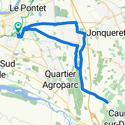
Panoramica
Su questo percorso
Questo è stato un buon percorso per uscire da Le Pontet, ma c'era inevitabilmente molto traffico. La D28 aveva per la maggior parte un ottimo margine stradale.
Un errore involontario lungo il cammino è stato perdere a Pernes-les-Fontaines l'uscita per la D28. Di conseguenza, ci siamo ritrovati sulla D1, che, pur avendo un traffico relativamente leggero, non offriva margine e ha allungato il nostro giro di diversi chilometri. Sono sicuro che la D28 sarebbe stata una strada con traffico ancora più basso a est di Pernes-les-Fontaines. Più tardi, dopo essere tornati a St-Didier sulla D39 più vicino al nostro percorso previsto, abbiamo trovato un percorso ciclabile segnalato che ci ha portato lungo strade di campagna che attraversavano i vigneti fino alla D4. Tutto era asfaltato, ma alcune parti non molto bene.
Prendere la Route de Beaucet (D247) fino a Venasque è stata ripida, ma è stata una delle migliori decisioni. (L'alternativa sarebbe stata quella di continuare sulla D4, che sono sicuro sarebbe stata molto piacevole.) Venasque era un villaggio molto carino con un castello che sovrastava il Mont Ventoux. Questa è stata una parte splendida del nostro giro.
La salita sulla D4 fino al Col de Murs (627M) è stata eccellente. Bella e con poco traffico. Penso che abbiamo visto più ciclisti che auto... e non abbiamo visto nemmeno tanti ciclisti. La discesa dal Col ha offerto alcune viste molto belle.
Grande giro che raccomandiamo vivamente.
- 6 h 32 min
- Durata
- 63 km
- Distanza
- 921 m
- Salita
- 555 m
- Discesa
- 9,6 km/h
- Velocità media
- 626 m
- Altitudine max.

Foto del percorso
 to Saint-Saturnin-lès-Apt\"")
 to Saint-Saturnin-lès-Apt\"")
 to Saint-Saturnin-lès-Apt\"")
 to Saint-Saturnin-lès-Apt\"")
 to Saint-Saturnin-lès-Apt\"")
 to Saint-Saturnin-lès-Apt\"")
 to Saint-Saturnin-lès-Apt\"")
 to Saint-Saturnin-lès-Apt\"")
Qualità del percorso
Tipi di percorsi e superfici lungo il percorso
Tipi di percorso
Strada
10,1 km
(16 %)
Strada tranquilla
8,2 km
(13 %)
Superfici
Asfaltato
52,9 km
(84 %)
Non asfaltato
0,6 km
(1 %)
Asfalto
52,9 km
(84 %)
Terra
0,6 km
(1 %)
Non definito
9,4 km
(15 %)
Continua con Bikemap
Usa, modifica o scarica questo percorso ciclabile
Vuoi percorrere Le Pontet (Avignon) to Saint-Saturnin-lès-Apt o personalizzarlo per il tuo viaggio? Ecco cosa puoi fare con questo percorso su Bikemap:
Funzionalità gratuite
- Salva questo percorso tra i preferiti o in una raccolta
- Copia e pianifica la tua versione di questo percorso
- Sincronizza il tuo percorso con Garmin o Wahoo
Funzionalità Premium
Prova gratuita di 3 giorni o pagamento una tantum. Scopri di più su Bikemap Premium.
- Naviga questo percorso su iOS e Android
- Esporta un file GPX / KML di questo percorso
- Crea la tua stampa personalizzata (provala gratis)
- Scarica questo percorso per la navigazione offline
Scopri altre funzionalità Premium.
Ottieni Bikemap PremiumDalla nostra community
Le Pontet: Altri percorsi popolari che iniziano qui
 110 km Monts de Vaucluse Le Pontet Murs Lioux Saint Lambert Indochinois Méthamis Malemort Pernes
- Distanza
- 109,7 km
- Salita
- 1.204 m
- Discesa
- 1.204 m
- Posizione
- Le Pontet, Provenza-Alpi-Costa Azzurra, Francia
 De 45 Rue Charles Chartier, Avignon à 45 Rue Charles Chartier, Avignon
- Distanza
- 22,5 km
- Salita
- 153 m
- Discesa
- 152 m
- Posizione
- Le Pontet, Provenza-Alpi-Costa Azzurra, Francia
 De 45 Rue Charles Chartier, Avignon à 45 Rue Charles Chartier, Avignon
- Distanza
- 29,9 km
- Salita
- 164 m
- Discesa
- 162 m
- Posizione
- Le Pontet, Provenza-Alpi-Costa Azzurra, Francia
 hghgh
hghgh- Distanza
- 2,1 km
- Salita
- 4 m
- Discesa
- 5 m
- Posizione
- Le Pontet, Provenza-Alpi-Costa Azzurra, Francia
 Le Pontet (Avignon) to Saint-Saturnin-lès-Apt
- Distanza
- 63 km
- Salita
- 921 m
- Discesa
- 555 m
- Posizione
- Le Pontet, Provenza-Alpi-Costa Azzurra, Francia
 De 45 Rue Charles Chartier, Avignon à 45 Rue Charles Chartier, Avignon
- Distanza
- 69,3 km
- Salita
- 11 m
- Discesa
- 27 m
- Posizione
- Le Pontet, Provenza-Alpi-Costa Azzurra, Francia
 De 45 Rue Charles Chartier, Avignon à 45 Rue Charles Chartier, Avignon
- Distanza
- 53,8 km
- Salita
- 257 m
- Discesa
- 258 m
- Posizione
- Le Pontet, Provenza-Alpi-Costa Azzurra, Francia
 avignon sault
- Distanza
- 59,9 km
- Salita
- 1.081 m
- Discesa
- 395 m
- Posizione
- Le Pontet, Provenza-Alpi-Costa Azzurra, Francia
Aprila nell’app