
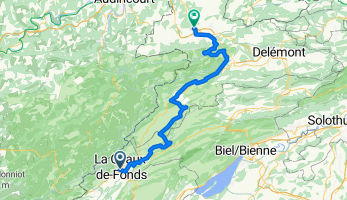
La Chaux-de-Fonds to Porrentruy
Un percorso ciclabile con partenza da La Chaux-de-Fonds, Cantone Neuchâtel, Svizzera.
Panoramica
Su questo percorso
- 4 h 55 min
- Durata
- 81,2 km
- Distanza
- 1.431 m
- Salita
- 1.997 m
- Discesa
- 16,5 km/h
- Velocità media
- 1.248 m
- Altitudine max.

Foto del percorso

Qualità del percorso
Tipi di percorsi e superfici lungo il percorso
Tipi di percorso
Strada tranquilla
52 km
(64 %)
Strada
8,1 km
(10 %)
Superfici
Asfaltato
48,7 km
(60 %)
Non asfaltato
3,2 km
(4 %)
Asfalto
41,4 km
(51 %)
Pavimentato (non definito)
7,3 km
(9 %)
Punti salienti del percorso
Punti di interesse lungo il percorso
Punto di interesse dopo 19,7 km
Observatoire Astronomique de Mont-Soleil
Punto di interesse dopo 33,2 km
Etang de la Gruère
Punto di interesse dopo 35,8 km
Etang des Royes
Punto di interesse dopo 62,4 km
St-Ursanne
Punto di interesse dopo 62,4 km
Cloître
Punto di interesse dopo 62,5 km
Pont Saint-Jean The small town of St-Ursanne, which annually welcomes far more tourists than it has inhabitants, can be entered through three town gates. The entrance from the south over the bridge and through the Porte St-Jean is very impressive. A statue of St. John of Nepomuk, patron saint of all bridges, stands on one of the abutments. His many other «commitments» as patron saint of confessors, rafters, millers, priests and mariners may have led to the fact that not all bridges could be saved from destruction. A first bridge must have stood around 1440. It can be assumed that it was also built of wood, as was one known from an earlier 16th century depiction of the town. Chroniclers reported that the winter in 1670 was so cold that even the wine in the cellars froze. At that time the wooden bridge was destroyed by ice flowing down the Doubs. The bridge subsequently built in 1728/29 by master builder Brunet to plans by Advocate Humbert, was adorned by the figure of Nepomuk, who appears to gaze up river to the site of the former bridge.
Punto di interesse dopo 62,6 km
Viewpoint
Punto di interesse dopo 70,8 km
Col de la Croix
Continua con Bikemap
Usa, modifica o scarica questo percorso ciclabile
Vuoi percorrere La Chaux-de-Fonds to Porrentruy o personalizzarlo per il tuo viaggio? Ecco cosa puoi fare con questo percorso su Bikemap:
Funzionalità gratuite
- Salva questo percorso tra i preferiti o in una raccolta
- Copia e pianifica la tua versione di questo percorso
- Dividilo in tappe per creare un tour di più giorni
- Sincronizza il tuo percorso con Garmin o Wahoo
Funzionalità Premium
Prova gratuita di 3 giorni o pagamento una tantum. Scopri di più su Bikemap Premium.
- Naviga questo percorso su iOS e Android
- Esporta un file GPX / KML di questo percorso
- Crea la tua stampa personalizzata (provala gratis)
- Scarica questo percorso per la navigazione offline
Scopri altre funzionalità Premium.
Ottieni Bikemap PremiumDalla nostra community
La Chaux-de-Fonds: Altri percorsi popolari che iniziano qui
- La Chaux-de-Fonds to Porrentruy
- Distanza
- 81,2 km
- Salita
- 1.431 m
- Discesa
- 1.997 m
- Posizione
- La Chaux-de-Fonds, Cantone Neuchâtel, Svizzera
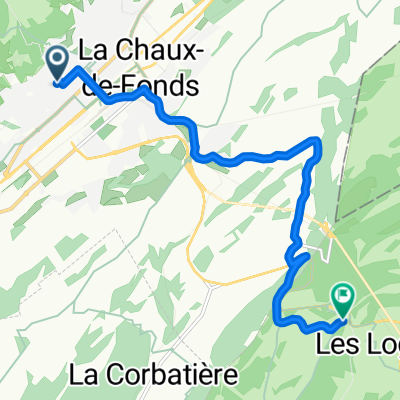 De Rue Combe-Grieurin à Route de la Vue-des-Alpes
- Distanza
- 9 km
- Salita
- 348 m
- Discesa
- 116 m
- Posizione
- La Chaux-de-Fonds, Cantone Neuchâtel, Svizzera
 2021 La Chaux-de-Fonds - Porrentruy
- Distanza
- 312 km
- Salita
- 495 m
- Discesa
- 1.070 m
- Posizione
- La Chaux-de-Fonds, Cantone Neuchâtel, Svizzera
 La Chaux-de-Fonds - St Croix
- Distanza
- 111,5 km
- Salita
- 1.316 m
- Discesa
- 1.316 m
- Posizione
- La Chaux-de-Fonds, Cantone Neuchâtel, Svizzera
 petite tour du matin
- Distanza
- 30,7 km
- Salita
- 1.163 m
- Discesa
- 1.156 m
- Posizione
- La Chaux-de-Fonds, Cantone Neuchâtel, Svizzera
 La Chaux-de-Fonds - Tête-de-Ran
- Distanza
- 19,5 km
- Salita
- 597 m
- Discesa
- 597 m
- Posizione
- La Chaux-de-Fonds, Cantone Neuchâtel, Svizzera
 12345
12345- Distanza
- 11,1 km
- Salita
- 301 m
- Discesa
- 227 m
- Posizione
- La Chaux-de-Fonds, Cantone Neuchâtel, Svizzera
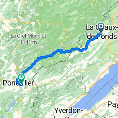 01 Route nach Pontarlier
- Distanza
- 58,5 km
- Salita
- 1.054 m
- Discesa
- 1.181 m
- Posizione
- La Chaux-de-Fonds, Cantone Neuchâtel, Svizzera
Aprila nell’app