

Wyland-Downtown Etappe 2: Zürich-Oberstrass – Winterthur Altstadt
- 24,4 km
- 275 m
- 351 m
- Zürich (Kreis 6) / Oberstrass, Canton Zurigo, Svizzera
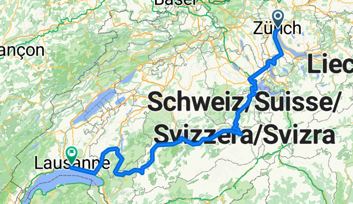
Altre informazioni sulla Lakes Route: https://www.cyclingthread.com/exploring-swiss-alps-cycling-lakes-route-in-switzerland La Lakes Route è un itinerario ciclistico di circa 500 chilometri attraverso una Svizzera da cartolina, che collega dieci laghi panoramici e regioni come Werdenberg, Lucerna ai piedi del monte Pilatus, Iseltwald sul lago di Brienz, Gruyères e i vigneti di Lavaux sopra il lago di Ginevra. La versione descritta parte da Zurigo e termina a Losanna, passando per Zug, Lucerna, Meiringen, Interlaken, Spiez e Gstaad. Secondo Switzerland Mobility, il percorso è lungo circa 510 km con un dislivello totale di circa 5900 m. Offre viste eccezionali sui laghi alpini, borghi incantevoli e valli, ed è perfetto per un viaggio di più giorni. Molti ciclisti pianificano da 6 a 8 giorni per completarlo, a seconda del ritmo e delle soste. Il suo profilo impegnativo, con salite e discese, lo rende sia sfidante sia gratificante. In definitiva, la Lakes Route è un'avventura ciclistica ben organizzata e panoramica che cattura la varietà dei paesaggi svizzeri.


Strada tranquilla
157 km46 %Strada
44,4 km13 %Asfaltato
204,8 km(60 %)Non asfaltato
27,3 km(8 %)Asfalto
194,5 km57 %Ghiaia
17,1 km5 %Prova gratuita di 3 giorni o pagamento una tantum. Scopri di più su Bikemap Premium.
Scopri altre funzionalità Premium.
Ottieni Bikemap PremiumAprila nell’app


