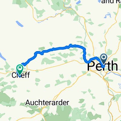
St Columba's Way- Perth to St Andrews
Un percorso ciclabile con partenza da Perth, Scotland, United Kingdom.
Panoramica
Su questo percorso
Cross bridge in Perth on Bike Route 77 and then follow quiet roads, riverside tracks and core paths. A bit hilly at first, up to 145 metres outside Perth, and then flat all the way with lovely views over the River Tay to Dundee and the famous railway bridge. Plenty of accommodation, pubs etc in Dundee.
Special Report. Avoid the dangerous rush, swamp and muddy areas on side of the Tay south of St Madoes and Errol.
From Dundee cross the road bridge onto Fife Coastal Path until heading inland along quiet roads and pedestrian walkways to St Andrews.
This is the 7th and final section of St Columba's Way, from Iona to St Andrews (website:http://www.thewayofstandrews.com)
- -:--
- Durata
- 73,2 km
- Distanza
- 266 m
- Salita
- 249 m
- Discesa
- ---
- Velocità media
- ---
- Altitudine max.
Qualità del percorso
Tipi di percorsi e superfici lungo il percorso
Tipi di percorso
Sentiero
19,1 km
(26 %)
Strada
12,5 km
(17 %)
Superfici
Asfaltato
30,6 km
(42 %)
Non asfaltato
7 km
(10 %)
Asfalto
29,3 km
(40 %)
Ghiaia
6,2 km
(8 %)
Punti salienti del percorso
Punti di interesse lungo il percorso
Punto di interesse dopo 8,6 km
BIKE ROUTE 77. Signposted from Perth to Dundee
Punto di interesse dopo 40,7 km
DUNDEE. Hotels, hostels, shops, pubs etc
Punto di interesse dopo 65,3 km
Guardbridge. The village derives its name from this 15th-century six-arched bridge over the Eden and is the site of the last hostel – or “gare” from the French word for station - where many pilgrims stayed before setting off on the final three miles (5 km) to St Andrews and the great cathedral holding the relics of St Andrew.
Continua con Bikemap
Usa, modifica o scarica questo percorso ciclabile
Vuoi percorrere St Columba's Way- Perth to St Andrews o personalizzarlo per il tuo viaggio? Ecco cosa puoi fare con questo percorso su Bikemap:
Funzionalità gratuite
- Salva questo percorso tra i preferiti o in una raccolta
- Copia e pianifica la tua versione di questo percorso
- Sincronizza il tuo percorso con Garmin o Wahoo
Funzionalità Premium
Prova gratuita di 3 giorni o pagamento una tantum. Scopri di più su Bikemap Premium.
- Naviga questo percorso su iOS e Android
- Esporta un file GPX / KML di questo percorso
- Crea la tua stampa personalizzata (provala gratis)
- Scarica questo percorso per la navigazione offline
Scopri altre funzionalità Premium.
Ottieni Bikemap PremiumDalla nostra community
Perth: Altri percorsi popolari che iniziano qui
- 50 Manson Crescent, Perth to 50 Manson Crescent, Perth
- Distanza
- 47,8 km
- Salita
- 328 m
- Discesa
- 330 m
- Posizione
- Perth, Scotland, United Kingdom
- St Columba's Way-Perth to Amulree
- Distanza
- 53,7 km
- Salita
- 729 m
- Discesa
- 469 m
- Posizione
- Perth, Scotland, United Kingdom
- Perth North Circular through Stanley
- Distanza
- 39,3 km
- Salita
- 269 m
- Discesa
- 268 m
- Posizione
- Perth, Scotland, United Kingdom
- 50 Manson Crescent, Perth to 50 Manson Crescent, Perth
- Distanza
- 49,3 km
- Salita
- 303 m
- Discesa
- 303 m
- Posizione
- Perth, Scotland, United Kingdom
- Moderate route in Perth
- Distanza
- 14,1 km
- Salita
- 15 m
- Discesa
- 17 m
- Posizione
- Perth, Scotland, United Kingdom
- JOGLE Day 7
- Distanza
- 95,8 km
- Salita
- 448 m
- Discesa
- 471 m
- Posizione
- Perth, Scotland, United Kingdom
- Day 25 Perth to Pitlochry
- Distanza
- 47,7 km
- Salita
- 587 m
- Discesa
- 502 m
- Posizione
- Perth, Scotland, United Kingdom
- almost mailer hill
- Distanza
- 5,1 km
- Salita
- 142 m
- Discesa
- 147 m
- Posizione
- Perth, Scotland, United Kingdom
Aprila nell’app