Cassis - Barjols
Un percorso ciclabile con partenza da Cassis, Provenza-Alpi-Costa Azzurra, Francia.
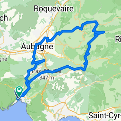
Panoramica
Su questo percorso
2.Etappe meiner Frankreich-Reise '08:
<table style="border-collapse: collapse; width: 98pt;" border="0" cellspacing="0" cellpadding="0" width="131"> <tbody> <tr style="height: 12.75pt;" height="17"> <td class="xl24" style="height: 12.75pt; width: 98pt;" width="131" height="17">
Cassis
</td> </tr> </tbody> </table>
<table style="border-collapse: collapse; width: 98pt;" border="0" cellspacing="0" cellpadding="0" width="131"> <tbody> <tr style="height: 12.75pt;" height="17"> <td class="xl25" style="height: 12.75pt;" height="17">
Mont de la Saoupe
</td> </tr> </tbody> </table> <table style="border-collapse: collapse; width: 98pt;" border="0" cellspacing="0" cellpadding="0" width="131"> <tbody> <tr style="height: 12.75pt;" height="17"> <td class="xl25" style="height: 12.75pt;" height="17">
Grde de Tête
</td> </tr> </tbody> </table> <table style="border-collapse: collapse; width: 98pt;" border="0" cellspacing="0" cellpadding="0" width="131"> <tbody> <tr style="height: 12.75pt;" height="17"> <td class="xl24" style="height: 12.75pt;" height="17">
La Ciotat
</td> </tr> </tbody> </table> <table style="border-collapse: collapse; width: 98pt;" border="0" cellspacing="0" cellpadding="0" width="131"> <tbody> <tr style="height: 12.75pt;" height="17"> <td class="xl24" style="height: 12.75pt;" height="17">
Ceyreste
</td> </tr> </tbody> </table> <table style="border-collapse: collapse; width: 98pt;" border="0" cellspacing="0" cellpadding="0" width="131"> <tbody> <tr style="height: 12.75pt;" height="17"> <td class="xl24" style="height: 12.75pt;" height="17">
Mauregard
</td> </tr> </tbody> </table> <table style="border-collapse: collapse; width: 98pt;" border="0" cellspacing="0" cellpadding="0" width="131"> <tbody> <tr style="height: 12.75pt;" height="17"> <td class="xl24" style="height: 12.75pt;" height="17">
Le Grd Caunet
</td> </tr> </tbody> </table> <table style="border-collapse: collapse; width: 98pt;" border="0" cellspacing="0" cellpadding="0" width="131"> <tbody> <tr style="height: 12.75pt;" height="17"> <td class="xl24" style="height: 12.75pt;" height="17">
Richtung Pinval / Gemenos
</td> </tr> </tbody> </table> <table style="border-collapse: collapse; width: 98pt;" border="0" cellspacing="0" cellpadding="0" width="131"> <tbody> <tr style="height: 12.75pt;" height="17"> <td class="xl24" style="height: 12.75pt;" height="17">
Gemenos
</td> </tr> </tbody> </table>
<table style="border-collapse: collapse; width: 98pt;" border="0" cellspacing="0" cellpadding="0" width="131"> <tbody> <tr style="height: 12.75pt;" height="17"> <td class="xl24" style="height: 12.75pt;" height="17"></td> </tr> </tbody> </table>
<table style="border-collapse: collapse; width: 98pt;" border="0" cellspacing="0" cellpadding="0" width="131"> <tbody> <tr style="height: 12.75pt;" height="17"> <td class="xl25" style="height: 12.75pt;" height="17">
Col d'Espigoulier
</td> </tr> </tbody> </table> <table style="border-collapse: collapse; width: 98pt;" border="0" cellspacing="0" cellpadding="0" width="131"> <tbody> <tr style="height: 12.75pt;" height="17"> <td class="xl24" style="height: 12.75pt;" height="17">
Plan-D'Aups
</td> </tr> </tbody> </table> <table style="border-collapse: collapse; width: 98pt;" border="0" cellspacing="0" cellpadding="0" width="131"> <tbody> <tr style="height: 12.75pt;" height="17"> <td class="xl24" style="height: 12.75pt;" height="17">
Mazaugues
</td> </tr> </tbody> </table> <table style="border-collapse: collapse; width: 98pt;" border="0" cellspacing="0" cellpadding="0" width="131"> <tbody> <tr style="height: 12.75pt;" height="17"> <td class="xl24" style="height: 12.75pt;" height="17"></td> </tr> </tbody> </table> <table style="border-collapse: collapse; width: 98pt;" border="0" cellspacing="0" cellpadding="0" width="131"> <tbody> <tr style="height: 12.75pt;" height="17"> <td class="xl24" style="height: 12.75pt;" height="17">
Les Censiés
</td> </tr> </tbody> </table> <table style="border-collapse: collapse; width: 98pt;" border="0" cellspacing="0" cellpadding="0" width="131"> <tbody> <tr style="height: 12.75pt;" height="17"> <td class="xl24" style="height: 12.75pt;" height="17">
Bras
</td> </tr> </tbody> </table> <table style="border-collapse: collapse; width: 98pt;" border="0" cellspacing="0" cellpadding="0" width="131"> <tbody> <tr style="height: 13.5pt;" height="18"> <td class="xl24" style="height: 13.5pt;" height="18">
Saint Estève
</td> </tr> </tbody> </table> <table style="border-collapse: collapse; width: 98pt;" border="0" cellspacing="0" cellpadding="0" width="131"> <tbody> <tr style="height: 12.75pt;" height="17"> <td class="xl24" style="height: 12.75pt;" height="17">
Brue Auriac
</td> </tr> </tbody> </table> <table style="border-collapse: collapse; width: 98pt;" border="0" cellspacing="0" cellpadding="0" width="131"> <tbody> <tr style="height: 12.75pt;" height="17"> <td class="xl24" style="height: 12.75pt;" height="17">
Barjols
</td> </tr> </tbody> </table>
<br />
<table style="border-collapse: collapse; width: 98pt;" border="0" cellspacing="0" cellpadding="0" width="131"> <tbody> </tbody> </table>
- -:--
- Durata
- 116,9 km
- Distanza
- 1.705 m
- Salita
- 1.542 m
- Discesa
- ---
- Velocità media
- ---
- Altitudine max.
Continua con Bikemap
Usa, modifica o scarica questo percorso ciclabile
Vuoi percorrere Cassis - Barjols o personalizzarlo per il tuo viaggio? Ecco cosa puoi fare con questo percorso su Bikemap:
Funzionalità gratuite
- Salva questo percorso tra i preferiti o in una raccolta
- Copia e pianifica la tua versione di questo percorso
- Dividilo in tappe per creare un tour di più giorni
- Sincronizza il tuo percorso con Garmin o Wahoo
Funzionalità Premium
Prova gratuita di 3 giorni o pagamento una tantum. Scopri di più su Bikemap Premium.
- Naviga questo percorso su iOS e Android
- Esporta un file GPX / KML di questo percorso
- Crea la tua stampa personalizzata (provala gratis)
- Scarica questo percorso per la navigazione offline
Scopri altre funzionalità Premium.
Ottieni Bikemap PremiumDalla nostra community
Cassis: Altri percorsi popolari che iniziano qui
- Cassis-Nice en vélo
- Distanza
- 299,6 km
- Salita
- 1.077 m
- Discesa
- 1.076 m
- Posizione
- Cassis, Provenza-Alpi-Costa Azzurra, Francia
- Cassis-Col d'Espigoulier
- Distanza
- 79,4 km
- Salita
- 1.082 m
- Discesa
- 1.082 m
- Posizione
- Cassis, Provenza-Alpi-Costa Azzurra, Francia
- 2016J20Soir : Casino de Cassis
- Distanza
- 1,7 km
- Salita
- 9 m
- Discesa
- 85 m
- Posizione
- Cassis, Provenza-Alpi-Costa Azzurra, Francia
- ride from Cassis to Marseille
- Distanza
- 21,4 km
- Salita
- 249 m
- Discesa
- 395 m
- Posizione
- Cassis, Provenza-Alpi-Costa Azzurra, Francia
- Barcelona 11
- Distanza
- 66 km
- Salita
- 750 m
- Discesa
- 737 m
- Posizione
- Cassis, Provenza-Alpi-Costa Azzurra, Francia
- Cassis - Barjols
- Distanza
- 116,9 km
- Salita
- 1.705 m
- Discesa
- 1.542 m
- Posizione
- Cassis, Provenza-Alpi-Costa Azzurra, Francia
- La Ciotat-callanques_cassis
- Distanza
- 30,6 km
- Salita
- 879 m
- Discesa
- 880 m
- Posizione
- Cassis, Provenza-Alpi-Costa Azzurra, Francia
- calanque d’en vau
- Distanza
- 16 km
- Salita
- 332 m
- Discesa
- 326 m
- Posizione
- Cassis, Provenza-Alpi-Costa Azzurra, Francia
Aprila nell’app