

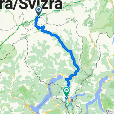
NL Rhine Cycle Route
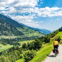
Un percorso ciclabile con partenza da Andermatt, Canton Uri, Svizzera.
Panoramica
Su questo percorso
La Ciclovia del Reno è lunga circa 1.360 chilometri e attraversa cinque paesi. Il percorso inizia nelle Alpi svizzere, la zona sorgente del Reno. Poi passa per Austria, Francia e Germania. Il percorso termina a Rotterdam, nei Paesi Bassi, dove il Reno sfocia nel Mare del Nord.
- -:--
- Durata
- 1.365,4 km
- Distanza
- 12 m
- Salita
- 1.447 m
- Discesa
- ---
- Velocità media
- ---
- Altitudine max.

Qualità del percorso
Tipi di percorsi e superfici lungo il percorso
Tipi di percorso
Strada forestale
368,7 km
(27 %)
Strada tranquilla
286,7 km
(21 %)
Superfici
Asfaltato
887,5 km
(65 %)
Non asfaltato
286,7 km
(21 %)
Asfalto
860,2 km
(63 %)
Ghiaia
177,5 km
(13 %)
Punti salienti del percorso
Punti di interesse lungo il percorso

Punto di interesse dopo 299,4 km
The Rhine Falls (Rheinfall in German) is the largest plain waterfall in Europe. They are 150 m wide and 23 m high.

Punto di interesse dopo 675,2 km
Speyer is one of the oldest cities in Germany and is therefore historically and culturally important. Most famous is the Imperial Cathedral of Speyer.

Punto di interesse dopo 839,2 km
The Lorelei is a rock on the eastern bank of the Rhine which soars some 120 metres above the waterline. It marks the narrowest part of the river between Switzerland and the North Sea, and is the most famous feature of the Rhine Gorge, a 65 km section of the river between Koblenz and Bingen that was added to the UNESCO World Heritage Sites in June 2002. A very strong current and rocks below the waterline have caused many boat accidents there. Lorelei is also the name of a feminine water spirit, similar to mermaids or Rhine maidens, associated with this rock in popular folklore and in works of music, art and literature.

Punto di interesse dopo 903,5 km
One of Andernach's natural attractions is the world's highest (max. 64 m) cold-water geyser, driven by carbon dioxide with force generated in a fashion similar to that in a shaken bottle of table water.
Continua con Bikemap
Usa, modifica o scarica questo percorso ciclabile
Vuoi percorrere NL Rhine Cycle Route o personalizzarlo per il tuo viaggio? Ecco cosa puoi fare con questo percorso su Bikemap:
Funzionalità gratuite
- Salva questo percorso tra i preferiti o in una raccolta
- Copia e pianifica la tua versione di questo percorso
- Dividilo in tappe per creare un tour di più giorni
- Sincronizza il tuo percorso con Garmin o Wahoo
Funzionalità Premium
Prova gratuita di 3 giorni o pagamento una tantum. Scopri di più su Bikemap Premium.
- Naviga questo percorso su iOS e Android
- Esporta un file GPX / KML di questo percorso
- Crea la tua stampa personalizzata (provala gratis)
- Scarica questo percorso per la navigazione offline
Scopri altre funzionalità Premium.
Ottieni Bikemap PremiumDalla nostra community
Andermatt: Altri percorsi popolari che iniziano qui
 Rhine Cycle Route, EuroVelo 15 - Andermatt to Basel
- Distanza
- 492,2 km
- Salita
- 6.424 m
- Discesa
- 7.590 m
- Posizione
- Andermatt, Canton Uri, Svizzera
 NL The Rhine Cycle Route
- Distanza
- 1.352,1 km
- Salita
- 88 m
- Discesa
- 1.523 m
- Posizione
- Andermatt, Canton Uri, Svizzera
 Furka-Nufenen-Gotthard-Oberalp
- Distanza
- 135,9 km
- Salita
- 4.637 m
- Discesa
- 4.527 m
- Posizione
- Andermatt, Canton Uri, Svizzera
 Andermatt 3
- Distanza
- 158,9 km
- Salita
- 3.905 m
- Discesa
- 3.702 m
- Posizione
- Andermatt, Canton Uri, Svizzera
 Bellinzona - Vizzola Ticino
- Distanza
- 130,7 km
- Salita
- 2.639 m
- Discesa
- 3.799 m
- Posizione
- Andermatt, Canton Uri, Svizzera
 Rheinradweg
- Distanza
- 1.085,7 km
- Salita
- 107 m
- Discesa
- 1.544 m
- Posizione
- Andermatt, Canton Uri, Svizzera
 Transalpine (7) Andermatt - Visp
- Distanza
- 89,5 km
- Salita
- 1.685 m
- Discesa
- 2.290 m
- Posizione
- Andermatt, Canton Uri, Svizzera
![[DAY 19] Göschenen - Ilanz](https://media.bikemap.net/routes/8561780/gallery/thumbs/af10c4bc-a85d-4013-8c11-c6c25ccc528a.jpeg.208x208_q80_crop.jpg) [DAY 19] Göschenen - Ilanz
[DAY 19] Göschenen - Ilanz- Distanza
- 68,1 km
- Salita
- 984 m
- Discesa
- 1.380 m
- Posizione
- Andermatt, Canton Uri, Svizzera
Aprila nell’app