

Rock cycling in Haugsdalen and Engleberget
Un percorso ciclabile con partenza da Mo, Hordaland Fylke, Norvegia.
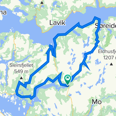
Panoramica
Su questo percorso
Questo è un percorso con single track e alcuni playground per il rock cycling.
Vai fino alla fine della strada di servizio a Svartavanet nella valle di Haugsdalen. Puoi andare in bici, in macchina o prendere la seggiovia da Matre, a un'ora a nord di Bergen.
Scendi e prendi a sinistra. Segui un single track e poi il tuo percorso nella natura e sulle rocce fino alla strada. Segui la strada indietro per 700 m e gira a sinistra. Lascia la strada poco prima del ponte, e davanti a te c'è un playground di rocce morbide. Puoi seguire entrambi i lati del fiume, ma normalmente attraverserò il fiume a breve distanza sotto il ponte e seguirò il lato destro.
A seconda del livello dell'acqua nel lago, attraversi il lato nord del lago. Se è pieno, può essere più facile salire sulla collina. Normalmente continui fino a un nuovo playground con rocce morbide fino a raggiungere la strada.
Segui la strada per 2 km verso sud dove è possibile fare una breve deviazione a sinistra.
Poi, dopo 300 m, lascia di nuovo la strada, e il playground di Engleberget è davanti a te. Trova la tua via sulle rocce fino al lago. Segui il lato sinistro/est intorno al lago. Nella parte interna scegli il livello di difficoltà per divertirti.
Nell'ultima parte verso la strada ci sono rocce piatte e lisce.
Bici full suspension è fortemente consigliata. Noleggio: www.bergfritid.no
- -:--
- Durata
- 11,5 km
- Distanza
- 557 m
- Salita
- 694 m
- Discesa
- ---
- Velocità media
- ---
- Altitudine max.

Continua con Bikemap
Usa, modifica o scarica questo percorso ciclabile
Vuoi percorrere Rock cycling in Haugsdalen and Engleberget o personalizzarlo per il tuo viaggio? Ecco cosa puoi fare con questo percorso su Bikemap:
Funzionalità gratuite
- Salva questo percorso tra i preferiti o in una raccolta
- Copia e pianifica la tua versione di questo percorso
- Sincronizza il tuo percorso con Garmin o Wahoo
Funzionalità Premium
Prova gratuita di 3 giorni o pagamento una tantum. Scopri di più su Bikemap Premium.
- Naviga questo percorso su iOS e Android
- Esporta un file GPX / KML di questo percorso
- Crea la tua stampa personalizzata (provala gratis)
- Scarica questo percorso per la navigazione offline
Scopri altre funzionalità Premium.
Ottieni Bikemap PremiumDalla nostra community
Mo: Altri percorsi popolari che iniziano qui
 Matre - Bjordal
- Distanza
- 34,2 km
- Salita
- 1.977 m
- Discesa
- 1.977 m
- Posizione
- Mo, Hordaland Fylke, Norvegia
 BF7 Matre Slovag
- Distanza
- 45,2 km
- Salita
- 1.310 m
- Discesa
- 1.690 m
- Posizione
- Mo, Hordaland Fylke, Norvegia
 BF5 Matre Bjordal Ortnevik
- Distanza
- 59,4 km
- Salita
- 3.145 m
- Discesa
- 3.126 m
- Posizione
- Mo, Hordaland Fylke, Norvegia
 Stølsheimen Vest: Fjordsykkelruta
- Distanza
- 217,5 km
- Salita
- 1.751 m
- Discesa
- 1.735 m
- Posizione
- Mo, Hordaland Fylke, Norvegia
 Stordalen: Anleggsveien
- Distanza
- 10,6 km
- Salita
- 263 m
- Discesa
- 348 m
- Posizione
- Mo, Hordaland Fylke, Norvegia
 Stølsheimen Vest
- Distanza
- 152,3 km
- Salita
- 1.505 m
- Discesa
- 1.504 m
- Posizione
- Mo, Hordaland Fylke, Norvegia
 BF3 Anleggsveien Stordalen
- Distanza
- 10,6 km
- Salita
- 355 m
- Discesa
- 440 m
- Posizione
- Mo, Hordaland Fylke, Norvegia
 BF1 Matresdalen
- Distanza
- 4,8 km
- Salita
- 759 m
- Discesa
- 499 m
- Posizione
- Mo, Hordaland Fylke, Norvegia
Aprila nell’app