

Sun City Bike Club Easy Ride 2 Out and Back Around Mesquite (With Some Climbs)
Un percorso ciclabile con partenza da Mesquite, Nevada, Stati Uniti.
Panoramica
Su questo percorso
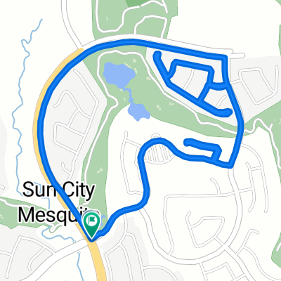
This out and back ride from Sun City Mesquite begins at the corner of Flat Top Mesa Drive and Falcon Ridge Parkway; heading South, the ride starts with a downhill on Falcon Ridge Parkway through the two roundabouts onto West Mesquite Boulevard; continuing East on a fairly flat section of West Mesquite Boulevard to a left turn onto North Grapevine Road; continuing on North Grapevine, the ride climbs over the bridge above Interstate 15, then heads downhill to West Pioneer Boulevard; the ride turns right and heads East on West Pioneer Boulevard - including a small climb and then a downhill - to Oasis Boulevard; continuing left onto Oasis Boulevard, the ride makes a very gradual climb to a roundabout, then turns right onto Ivy Lee Crest; the ride continues on Ivy Lee Crest and climbs to a right turn onto Amen Court for a quick ride through The Masters development; the ride continues with a left turn back onto Ivy Lee Crest for a nice downhill to a right turn back onto Oasis Boulevard; the ride continues by climbing gradrually to a right turn onto Lasso Lane and a ride through the Sierra Ridge development by a right turn onto Saddle Way and a left jog onto Wild Horse Lane; ;the ride leaves Sierra Rdge by turning left onto Wingate Drive, passing the "Sphinx of Mesquite", going through another roundabout back onto Oasis Boulevard and descending to Kensington Avenue; the ride continues with a right turn onto Kensington Avenue and a steep climb to the Stone Haven development; the ride enters Stone Haven by turning right onto Stone Haven Lane, continues with a a right onto Stone Haven Street, then a jog to the left onto Coventry Lane, another left jog onto Manchester Lane and a right onto Mendicino Lane; the ride leaves Stone Haven by turning left onto Mesquite Heights Road (aka "the dumo road") for a short downhill to a right turn onto Canyon Crest Boulevard; the ride continues on a steep downhill on Canyon Crest, then a jog to the left onto Horizon Boulevard, where riders continue a short descent and then make a short but steep climb to Hardy Way; turning right onto Hardy Way, the ride climbs and then descends to a right turn onto Falcon Ridge Parkway; the ride ends with a slight climb to the ride starting point at the corner of Flat Top Mesa Drive and Falcon Ridge Parkway. Total Ride Distance: 12.5 Miles.
Notes: 1. If you open the route in Google Roadmap or Google Hybrid (pulled down from the "Relief Map" tab) you will get a more up-to-date (but not completely accurate) view of the roads and paths. Some of the other maps are well dated. 2. There are some climbs on this route. While some of the climbs are a bit steep, most are not long and are managed if you relax and enjoy the work. 3. This mapping program tends to under-compute the total ride mileage by roughly 10%, based on mileage for this ride when it has been actually ridden. - -:--
- Durata
- 20,1 km
- Distanza
- 213 m
- Salita
- 215 m
- Discesa
- ---
- Velocità media
- ---
- Altitudine max.
Qualità del percorso
Tipi di percorsi e superfici lungo il percorso
Tipi di percorso
Strada trafficata
9 km
(45 %)
Strada
7,1 km
(35 %)
Superfici
Asfaltato
8,1 km
(40 %)
Asfalto
8,1 km
(40 %)
Non definito
12,1 km
(60 %)
Continua con Bikemap
Usa, modifica o scarica questo percorso ciclabile
Vuoi percorrere Sun City Bike Club Easy Ride 2 Out and Back Around Mesquite (With Some Climbs) o personalizzarlo per il tuo viaggio? Ecco cosa puoi fare con questo percorso su Bikemap:
Funzionalità gratuite
- Salva questo percorso tra i preferiti o in una raccolta
- Copia e pianifica la tua versione di questo percorso
- Sincronizza il tuo percorso con Garmin o Wahoo
Funzionalità Premium
Prova gratuita di 3 giorni o pagamento una tantum. Scopri di più su Bikemap Premium.
- Naviga questo percorso su iOS e Android
- Esporta un file GPX / KML di questo percorso
- Crea la tua stampa personalizzata (provala gratis)
- Scarica questo percorso per la navigazione offline
Scopri altre funzionalità Premium.
Ottieni Bikemap PremiumDalla nostra community
Mesquite: Altri percorsi popolari che iniziano qui
 Sun City Bike Club Easy Ride 3 (Tannery Cove)
- Distanza
- 4,5 km
- Salita
- 114 m
- Discesa
- 114 m
- Posizione
- Mesquite, Nevada, Stati Uniti
 Sun City Bike Club Easy Ride 4 (Wagon Wheel, Overland Trail and Frontier Pass Neighborhoods)
- Distanza
- 5 km
- Salita
- 91 m
- Discesa
- 89 m
- Posizione
- Mesquite, Nevada, Stati Uniti
 870 Deep Gorge Trail, Mesquite to 1350 Flat Top Mesa Dr, Mesquite
- Distanza
- 27,3 km
- Salita
- 281 m
- Discesa
- 243 m
- Posizione
- Mesquite, Nevada, Stati Uniti
 Mesquite, NV - Dolan Springs, NV
- Distanza
- 238,4 km
- Salita
- 1.600 m
- Discesa
- 1.046 m
- Posizione
- Mesquite, Nevada, Stati Uniti
 Mesquite, NV - Mount Charleston, NV
- Distanza
- 182,8 km
- Salita
- 2.261 m
- Discesa
- 464 m
- Posizione
- Mesquite, Nevada, Stati Uniti
 Cycle-a-thon for Cancer
- Distanza
- 16,3 km
- Salita
- 132 m
- Discesa
- 162 m
- Posizione
- Mesquite, Nevada, Stati Uniti
 Recovered Route
- Distanza
- 12,1 km
- Salita
- 278 m
- Discesa
- 231 m
- Posizione
- Mesquite, Nevada, Stati Uniti
 1350 Flat Top Mesa Dr, Mesquite to 1173 Clouds Rest Pt, Mesquite
- Distanza
- 0,9 km
- Salita
- 21 m
- Discesa
- 32 m
- Posizione
- Mesquite, Nevada, Stati Uniti
Aprila nell’app