

Sun City Bike Club Hard Ride 1 Out and Back Through Bunkerville to the I-15 Interchange
Un percorso ciclabile con partenza da Mesquite, Nevada, Stati Uniti.
Panoramica
Su questo percorso
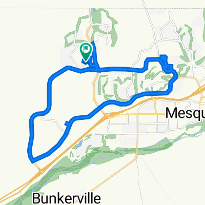
This rides starts at the corner of Flat Top Mesa Drive and Falcon Ridge Parkway; continues on a downhill run South through the two roundabouts; then turns right off the second roundabout, crossing Leavett Lane to Hafen Lane; the ride continues by turning left (East) on Hafen Lane and riding to the intersection of NV 170 (Riverside Drive); riders now turn right onto Riverside Drive and continue on a lengthy ride of rollers through Bunkerville all the way to the I-15 interchange - there is a lengthy grade that begins passed the bridge that crosses the Virgin River all the way to the I-15 interchange; here the riders turn around and trace the same route along Riverside Drive back into Mesquite; at the corner of Riverside Drive and West Mesquite Boulevard, riders turn left (West) onto West Mesquite Boulevard and ride through the two roundabouts, bearing right on both of them onto Falcon Ridge Parkway; the ride ends with the climb along Falcon Ridge Parkway back to the starting point at the corner of Flat Top Mesa Drive and Falcon Ridge Parkway. Total Ride Distance: 30.13 Miles.
Notes: 1. If you open the route in Google Roadmap or Google Hybrid (pulled down from the "Relief Map" tab) you will get a more up-to-date view of the roads and paths. Some of the other maps are dated. 2. This mapping program tends to under-compute the total ride mileage by roughly 10%, based on mileage for this ride when it has been actually ridden. - -:--
- Durata
- 48,5 km
- Distanza
- 288 m
- Salita
- 287 m
- Discesa
- ---
- Velocità media
- ---
- Altitudine max.
Qualità del percorso
Tipi di percorsi e superfici lungo il percorso
Tipi di percorso
Pista ciclabile
6,8 km
(14 %)
Strada
2,4 km
(5 %)
Superfici
Asfaltato
43,7 km
(90 %)
Asfalto
37,8 km
(78 %)
Calcestruzzo
5,8 km
(12 %)
Non definito
4,9 km
(10 %)
Continua con Bikemap
Usa, modifica o scarica questo percorso ciclabile
Vuoi percorrere Sun City Bike Club Hard Ride 1 Out and Back Through Bunkerville to the I-15 Interchange o personalizzarlo per il tuo viaggio? Ecco cosa puoi fare con questo percorso su Bikemap:
Funzionalità gratuite
- Salva questo percorso tra i preferiti o in una raccolta
- Copia e pianifica la tua versione di questo percorso
- Sincronizza il tuo percorso con Garmin o Wahoo
Funzionalità Premium
Prova gratuita di 3 giorni o pagamento una tantum. Scopri di più su Bikemap Premium.
- Naviga questo percorso su iOS e Android
- Esporta un file GPX / KML di questo percorso
- Crea la tua stampa personalizzata (provala gratis)
- Scarica questo percorso per la navigazione offline
Scopri altre funzionalità Premium.
Ottieni Bikemap PremiumDalla nostra community
Mesquite: Altri percorsi popolari che iniziano qui
 Crescent Moon Crossing 830, Mesquite to Crescent Moon Bend 829, Mesquite
- Distanza
- 3,4 km
- Salita
- 44 m
- Discesa
- 45 m
- Posizione
- Mesquite, Nevada, Stati Uniti
 870 Deep Gorge Trail, Mesquite to 1350 Flat Top Mesa Dr, Mesquite
- Distanza
- 27,3 km
- Salita
- 281 m
- Discesa
- 243 m
- Posizione
- Mesquite, Nevada, Stati Uniti
 Settlers Way, Mesquite to 870 Deep Gorge Trail, Mesquite
- Distanza
- 23,8 km
- Salita
- 331 m
- Discesa
- 324 m
- Posizione
- Mesquite, Nevada, Stati Uniti
 Sun City Bike Club Easy Ride 2 Out and Back Around Mesquite (With Some Climbs)
- Distanza
- 20,1 km
- Salita
- 213 m
- Discesa
- 215 m
- Posizione
- Mesquite, Nevada, Stati Uniti
 Sun City Bike Club Easy Ride 2 Out and Back Around Mesquite (With Some Climbs)
- Distanza
- 20,1 km
- Salita
- 81 m
- Discesa
- 82 m
- Posizione
- Mesquite, Nevada, Stati Uniti
 Settlers Way, Mesquite to 1350 Flat Top Mesa Dr, Mesquite
- Distanza
- 15,1 km
- Salita
- 232 m
- Discesa
- 194 m
- Posizione
- Mesquite, Nevada, Stati Uniti
 1350 Flat Top Mesa Dr, Mesquite to 1173 Clouds Rest Pt, Mesquite
- Distanza
- 0,9 km
- Salita
- 21 m
- Discesa
- 32 m
- Posizione
- Mesquite, Nevada, Stati Uniti
 Mesquite half loop.
- Distanza
- 17,6 km
- Salita
- 253 m
- Discesa
- 256 m
- Posizione
- Mesquite, Nevada, Stati Uniti
Aprila nell’app