

A Coffee + Architecture + Platting + Infrastructure + Beer Exploration
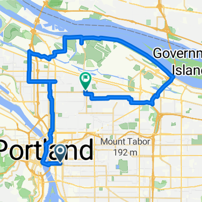
Un percorso ciclabile con partenza da Portland, Oregon, Stati Uniti.
Panoramica
Su questo percorso
Cose che vedremo/faremo.
Passeremo sul Steel Bridge - un ponte di 104 anni che ospita tram leggeri, autobus, pedoni, biciclette, treni merci, treni passeggeri e anche trattori. È il cavallo di lavoro di Portland dal 1912!
Cup & Bar - uno dei nuovi torrefattori in città, consegna in bici da carico, con un'area aperta per rilassarsi/hackerare/fare ciclismo, ecc. Situato vicino a due delle nuove stravaganti torri residenziali in costruzione.
Ladd's Addition, uno dei primi quartieri, un quartiere pianificato per tram, di Portland, tracciato e costruito tra il 1905 e il 1930.
Apex Bar/Birreria. Ottimo bar con musica rock, più parcheggi per biciclette di quanto tu possa immaginare (e probabilmente ci legheremo ancora agli alberi) e un'impressionante selezione di birre locali (dozzine e dozzine di esse!).
Il Tillikum Bridge è il nuovo ponte di trasporto, ciclismo e pedoni di Portland. Ci dirigeremo lungo alcuni dei nuovi MUP (Mixed Use Path) fino al ponte, dove potrai vedere la confluenza di tram, treni leggeri e autobus che attraversano il ponte, e probabilmente ciclisti e pedoni ovunque. È un bel ponte, aperto lo scorso anno a settembre!
Torneremo lungo il lato sud del MUP (Mixed Use Path) del lungomare.
- -:--
- Durata
- 9,9 km
- Distanza
- 122 m
- Salita
- 121 m
- Discesa
- ---
- Velocità media
- ---
- Altitudine max.

Qualità del percorso
Tipi di percorsi e superfici lungo il percorso
Tipi di percorso
Strada tranquilla
3,6 km
(36 %)
Pista ciclabile
2,7 km
(27 %)
Superfici
Asfaltato
8,6 km
(87 %)
Asfalto
3,9 km
(39 %)
Pavimentato (non definito)
2,4 km
(24 %)
Continua con Bikemap
Usa, modifica o scarica questo percorso ciclabile
Vuoi percorrere A Coffee + Architecture + Platting + Infrastructure + Beer Exploration o personalizzarlo per il tuo viaggio? Ecco cosa puoi fare con questo percorso su Bikemap:
Funzionalità gratuite
- Salva questo percorso tra i preferiti o in una raccolta
- Copia e pianifica la tua versione di questo percorso
- Sincronizza il tuo percorso con Garmin o Wahoo
Funzionalità Premium
Prova gratuita di 3 giorni o pagamento una tantum. Scopri di più su Bikemap Premium.
- Naviga questo percorso su iOS e Android
- Esporta un file GPX / KML di questo percorso
- Crea la tua stampa personalizzata (provala gratis)
- Scarica questo percorso per la navigazione offline
Scopri altre funzionalità Premium.
Ottieni Bikemap PremiumDalla nostra community
Portland: Altri percorsi popolari che iniziano qui
 Portland to Casc Locks OR via I 84
- Distanza
- 71,7 km
- Salita
- 318 m
- Discesa
- 316 m
- Posizione
- Portland, Oregon, Stati Uniti
 50mi loop to troutdale
- Distanza
- 75,9 km
- Salita
- 278 m
- Discesa
- 274 m
- Posizione
- Portland, Oregon, Stati Uniti
 Waterfront 8/9/17
- Distanza
- 17 km
- Salita
- 131 m
- Discesa
- 133 m
- Posizione
- Portland, Oregon, Stati Uniti
 Ride to Rhody
- Distanza
- 89 km
- Salita
- 1.095 m
- Discesa
- 444 m
- Posizione
- Portland, Oregon, Stati Uniti
 Wednesday 9/24
- Distanza
- 37,7 km
- Salita
- 225 m
- Discesa
- 187 m
- Posizione
- Portland, Oregon, Stati Uniti
 august: a taylor swift ride v1
- Distanza
- 15,4 km
- Salita
- 98 m
- Discesa
- 103 m
- Posizione
- Portland, Oregon, Stati Uniti
 august: a taylor swift ride v2
- Distanza
- 18,9 km
- Salita
- 116 m
- Discesa
- 121 m
- Posizione
- Portland, Oregon, Stati Uniti
 A Coffee + Architecture + Platting + Infrastructure + Beer Exploration
- Distanza
- 9,9 km
- Salita
- 122 m
- Discesa
- 121 m
- Posizione
- Portland, Oregon, Stati Uniti
Aprila nell’app