

St Ninian's Way- Girvan to Maybole
Un percorso ciclabile con partenza da Girvan, Scozia, Regno Unito.
Panoramica
Su questo percorso
Girvan to Maybole 24 km
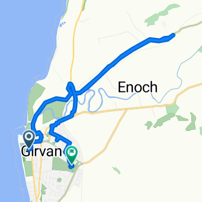
This 19th section of St Ninian’s Way starts at the centre of Girvan on the signposted Ayrshire Coastal Path. Go north along the coast to Dipple (6km) . Join the A77 briefly and then continue along the coast on ACP to Turnberry (3km). Continue north along coast, then turn east, through airport and go north to junction with A719 at Maidens (3 km). Go east along A719 to junction with minor road going south (1.5km). . Take minor road to T-junction with A77(2 km). Turn left and go north-east along the A77 To Kirkoswald (1 km). Visit Souter Johnnie’s Cottage. Continue along A 77 to junction with minor road going South (.5km). Go south along minor road for 100 m and then turn left across ford and proceed to road junction with A77 (3 km) . Go 500 m along A77, with Crossmraguel Abbey on your right, and leave the A77 onto a minor road, which continues alongside A77 to Carrick Academy((2km) , then take the A77 to Maybole centre and Town Hall (.5 km).
Coastal path,then into the Ayrshire hills.
Also part of the Whithorn Way - http://www.whithornway.org . courtesy of the WWSG where a detailed route description with grid references is available.
For a map overview of Part 1 and Part 2 of St Ninian’s Way please go to https://www.bikemap.net/en/route/3548129-st-ninians-way-carlisle-to-st-andrews-part-1-carlisle-to-whithorn/
St Ninian’s Way is one of the great pilgrim routes in Scotland to St Andrews - The Way of St Andrews - For other routes see http://www.thewayofstandrews.com
- -:--
- Durata
- 23,9 km
- Distanza
- 206 m
- Salita
- 128 m
- Discesa
- ---
- Velocità media
- ---
- Altitudine max.

Continua con Bikemap
Usa, modifica o scarica questo percorso ciclabile
Vuoi percorrere St Ninian's Way- Girvan to Maybole o personalizzarlo per il tuo viaggio? Ecco cosa puoi fare con questo percorso su Bikemap:
Funzionalità gratuite
- Salva questo percorso tra i preferiti o in una raccolta
- Copia e pianifica la tua versione di questo percorso
- Sincronizza il tuo percorso con Garmin o Wahoo
Funzionalità Premium
Prova gratuita di 3 giorni o pagamento una tantum. Scopri di più su Bikemap Premium.
- Naviga questo percorso su iOS e Android
- Esporta un file GPX / KML di questo percorso
- Crea la tua stampa personalizzata (provala gratis)
- Scarica questo percorso per la navigazione offline
Scopri altre funzionalità Premium.
Ottieni Bikemap PremiumDalla nostra community
Girvan: Altri percorsi popolari che iniziano qui
 Girvan and South Carrick Ward, Girvan to Girvan and South Carrick Ward, Girvan
- Distanza
- 28,3 km
- Salita
- 339 m
- Discesa
- 339 m
- Posizione
- Girvan, Scozia, Regno Unito
 Hervey Road 1 to The Clachan 36, Barr
- Distanza
- 13,7 km
- Salita
- 288 m
- Discesa
- 188 m
- Posizione
- Girvan, Scozia, Regno Unito
 Sophie and emma
- Distanza
- 10,1 km
- Salita
- 230 m
- Discesa
- 219 m
- Posizione
- Girvan, Scozia, Regno Unito
 Girvan Mini Gravel
- Distanza
- 12,8 km
- Salita
- 160 m
- Discesa
- 160 m
- Posizione
- Girvan, Scozia, Regno Unito
 15 Back Road, Girvan to 47 Main Street, Girvan
- Distanza
- 99,8 km
- Salita
- 963 m
- Discesa
- 971 m
- Posizione
- Girvan, Scozia, Regno Unito
 ayrshire
- Distanza
- 66,6 km
- Salita
- 500 m
- Discesa
- 497 m
- Posizione
- Girvan, Scozia, Regno Unito
 23 Back Road, Girvan to 47 Main Street, Girvan
- Distanza
- 100,4 km
- Salita
- 1.279 m
- Discesa
- 1.285 m
- Posizione
- Girvan, Scozia, Regno Unito
 11 Back Road, Girvan to 47 Main Street, Girvan
- Distanza
- 23,9 km
- Salita
- 488 m
- Discesa
- 496 m
- Posizione
- Girvan, Scozia, Regno Unito
Aprila nell’app