

St Ninian's Way - Lochwinnoch to Paisley
Un percorso ciclabile con partenza da Lochwinnoch, Scozia, Regno Unito.
Panoramica
Su questo percorso
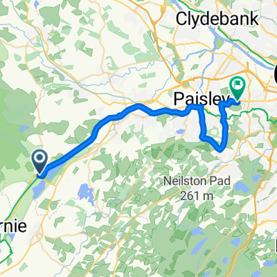
Lochwinnoch a Paisley
Questa 24ª sezione del Cammino di San Ninian segue un sentiero segnalato e la Ciclovia Nazionale 7 fino a Paisley. Il punto di partenza è il sentiero accanto al Castle Semple Loch che prosegue fino a un ponte sopra un'autostrada (6 km). Poi continua verso nord lungo il Black Cart Water fino a un altro ponte (2 km). Attraversa il ponte e continua lungo il sentiero fino a Elderslie (1,5 km), e poi fino a Sauce Hill, appena a sud di Paisley (3 km). Poi prendi la Causeyside Road per 200 m e svolta a destra in Gordon Street per 100 m, oltre il fiume Clyde, su Cotton Street fino all'Abazia di Paisley (300 m). Una opzione è continuare su Gauze Street e alla rotonda con la Cattedrale Cattolica di St Mirren.
Sentiero panoramico e segnalato
Fà anche parte del Whithorn Way - http://www.whithornway.org . Grazie alla WWSG dove è disponibile una descrizione dettagliata del percorso con riferimenti cartografici.
Per una panoramica della mappa della Parte 1 e Parte 2 del Cammino di San Ninian, visita https://www.bikemap.net/en/route/3548129-st-ninians-way-carlisle-to-st-andrews-part-1-carlisle-to-whithorn/
Il Cammino di San Ninian è uno dei grandi percorsi di pellegrinaggio in Scozia verso St Andrews - Il Cammino di St Andrews - Per altri percorsi vedere http://www.thewayofstandrews.com
- -:--
- Durata
- 15,9 km
- Distanza
- 65 m
- Salita
- 85 m
- Discesa
- ---
- Velocità media
- ---
- Altitudine max.

Qualità del percorso
Tipi di percorsi e superfici lungo il percorso
Tipi di percorso
Pista ciclabile
14,5 km
(91 %)
Strada
0,2 km
(1 %)
Superfici
Asfaltato
14,5 km
(91 %)
Asfalto
14,5 km
(91 %)
Non definito
1,4 km
(9 %)
Punti salienti del percorso
Punti di interesse lungo il percorso
Punto di interesse dopo 15,8 km
St Mirin's Cathedral
Punto di interesse dopo 15,8 km
Paisley Abbey
Continua con Bikemap
Usa, modifica o scarica questo percorso ciclabile
Vuoi percorrere St Ninian's Way - Lochwinnoch to Paisley o personalizzarlo per il tuo viaggio? Ecco cosa puoi fare con questo percorso su Bikemap:
Funzionalità gratuite
- Salva questo percorso tra i preferiti o in una raccolta
- Copia e pianifica la tua versione di questo percorso
- Sincronizza il tuo percorso con Garmin o Wahoo
Funzionalità Premium
Prova gratuita di 3 giorni o pagamento una tantum. Scopri di più su Bikemap Premium.
- Naviga questo percorso su iOS e Android
- Esporta un file GPX / KML di questo percorso
- Crea la tua stampa personalizzata (provala gratis)
- Scarica questo percorso per la navigazione offline
Scopri altre funzionalità Premium.
Ottieni Bikemap PremiumDalla nostra community
Lochwinnoch: Altri percorsi popolari che iniziano qui
 Barn Cottage, Kilbirnie Road, Lochwinnoch to Erskine Garden Centre, Bishopton
- Distanza
- 34,7 km
- Salita
- 119 m
- Discesa
- 140 m
- Posizione
- Lochwinnoch, Scozia, Regno Unito
 Route from East Lochhead, Kilbirnie Road, Lochwinnoch
- Distanza
- 29,9 km
- Salita
- 504 m
- Discesa
- 550 m
- Posizione
- Lochwinnoch, Scozia, Regno Unito
 Stewarton Circuit
- Distanza
- 58,7 km
- Salita
- 411 m
- Discesa
- 411 m
- Posizione
- Lochwinnoch, Scozia, Regno Unito
 Barn Cottage, Kilbirnie Road, Lochwinnoch to Fairlie House, Main Road, Largs
- Distanza
- 23,8 km
- Salita
- 435 m
- Discesa
- 484 m
- Posizione
- Lochwinnoch, Scozia, Regno Unito
 Church Street 17 to Kilbirnie Road
- Distanza
- 3,9 km
- Salita
- 40 m
- Discesa
- 13 m
- Posizione
- Lochwinnoch, Scozia, Regno Unito
 Etape 21 : Lochwinnoch-Glasgow
- Distanza
- 41,2 km
- Salita
- 186 m
- Discesa
- 125 m
- Posizione
- Lochwinnoch, Scozia, Regno Unito
 Harvey Square to Bathgo Avenue
- Distanza
- 26,1 km
- Salita
- 113 m
- Discesa
- 180 m
- Posizione
- Lochwinnoch, Scozia, Regno Unito
 Lochwinnoch -
- Distanza
- 23 km
- Salita
- 113 m
- Discesa
- 147 m
- Posizione
- Lochwinnoch, Scozia, Regno Unito
Aprila nell’app