

Säntis Classic
Un percorso ciclabile con partenza da Weinfelden, Canton Turgovia, Svizzera.
Panoramica
Su questo percorso
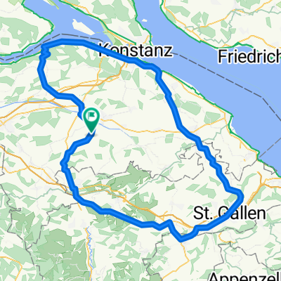
This loop follows the route of the Säntis Classic, an annual challenge that attracts almost 2000 cyclists.
Leaving Weinfelden in Canton Thurgau, the road rises gently in the countryside before descending to Wil. This is where you enter Canton St. Gallen.
The route undulates as it enters the hilly Toggenburg region. At Ebnat-Kappel, you continue to follow the Thur river upstream along the valley’s flank, taking a charming little road that meanders amid the farms away from the traffic.
The main ascent starts at Neu Sankt Johann and consists of a number of ramps (gradient: 7-8%) through the meadows interspersed with level sections. The pass itself is reached at alt. 1278m and offers views of the Säntis (alt. 2502m), the main peak in the regions which can be accessed via aerial cableway. In fine weather, this peak offers views not only of Switzerland, but also of Germany, Austria, Liechtenstein and France!
A rapid descent leads to Urnäsch, after which a series of back roads bring you to Herisau, the capital of Canton Appenzell Ausserrhoden. The 40km return leg to Weinfelden is largely downhill.
- -:--
- Durata
- 123,8 km
- Distanza
- 1.204 m
- Salita
- 1.204 m
- Discesa
- ---
- Velocità media
- ---
- Altitudine max.

Qualità del percorso
Tipi di percorsi e superfici lungo il percorso
Tipi di percorso
Strada
39,6 km
(32 %)
Strada tranquilla
33,4 km
(27 %)
Superfici
Asfaltato
94,1 km
(76 %)
Asfalto
81,7 km
(66 %)
Pavimentato (non definito)
12,4 km
(10 %)
Non definito
29,7 km
(24 %)
Continua con Bikemap
Usa, modifica o scarica questo percorso ciclabile
Vuoi percorrere Säntis Classic o personalizzarlo per il tuo viaggio? Ecco cosa puoi fare con questo percorso su Bikemap:
Funzionalità gratuite
- Salva questo percorso tra i preferiti o in una raccolta
- Copia e pianifica la tua versione di questo percorso
- Dividilo in tappe per creare un tour di più giorni
- Sincronizza il tuo percorso con Garmin o Wahoo
Funzionalità Premium
Prova gratuita di 3 giorni o pagamento una tantum. Scopri di più su Bikemap Premium.
- Naviga questo percorso su iOS e Android
- Esporta un file GPX / KML di questo percorso
- Crea la tua stampa personalizzata (provala gratis)
- Scarica questo percorso per la navigazione offline
Scopri altre funzionalità Premium.
Ottieni Bikemap PremiumDalla nostra community
Weinfelden: Altri percorsi popolari che iniziano qui
 Friltschen - Herisau - Kreuzlingen - Friltschen CLONED FROM ROUTE 221516
- Distanza
- 115,9 km
- Salita
- 710 m
- Discesa
- 710 m
- Posizione
- Weinfelden, Canton Turgovia, Svizzera
 32km Roundtrip from Friltschen
- Distanza
- 31,8 km
- Salita
- 502 m
- Discesa
- 498 m
- Posizione
- Weinfelden, Canton Turgovia, Svizzera
 thurathlon 2014 velostrecke
- Distanza
- 47,5 km
- Salita
- 479 m
- Discesa
- 479 m
- Posizione
- Weinfelden, Canton Turgovia, Svizzera
 Rund um Weinfelden flach
- Distanza
- 31,5 km
- Salita
- 115 m
- Discesa
- 115 m
- Posizione
- Weinfelden, Canton Turgovia, Svizzera
 Frauenfeld-Weinfelden
- Distanza
- 33,6 km
- Salita
- 80 m
- Discesa
- 80 m
- Posizione
- Weinfelden, Canton Turgovia, Svizzera
 Route in Bussnang
- Distanza
- 30,5 km
- Salita
- 494 m
- Discesa
- 492 m
- Posizione
- Weinfelden, Canton Turgovia, Svizzera
 Klasse 1Ga Freitag
- Distanza
- 11,5 km
- Salita
- 73 m
- Discesa
- 47 m
- Posizione
- Weinfelden, Canton Turgovia, Svizzera
 thurathlon 14 laufen kurz(1)/lang(2)
- Distanza
- 11,5 km
- Salita
- 48 m
- Discesa
- 46 m
- Posizione
- Weinfelden, Canton Turgovia, Svizzera
Aprila nell’app