

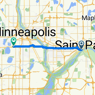
B2B00192 55102>55404viaShepherdRd/MissBlvd/WRiverPkwy/MidtwnGrnway
Un percorso ciclabile con partenza da Saint Paul, Minnesota, Stati Uniti.
Panoramica
Su questo percorso
Questo percorso è decisamente più lungo ma molto più interessante e veloce. Poche fermate rispetto a un percorso attraverso la città. Prendi Shepherd Road West lungo il fiume Mississippi. Puoi andare o sulla pista ciclabile o sulla strada. Segui Shepherd Rd. oltre 35E fino a quando diventa East Mississippi River Blvd. Continua su East Mississippi oltre lo stabilimento Ford. Procedi sotto il ponte Ford Pkwy e fai subito una curva a gomito a destra fino a Ford Pkwy e attraversa il Mississippi sul ponte Ford. Immediatamente alla fine del ponte c'è un sentiero a destra che ti porterà giù fino a West River Pkwy. Segui West River Pkwy. sia sulla strada che sulla pista ciclabile. Passa sotto Lake Street e continua. A E.27th Street c'è un sentiero che sale verso la Midtown Greenway Bike Trail. Prendi il sentiero ciclabile verso ovest. All'incrocio con Hiawatha Avenue puoi continuare dritto e attraversare con il semaforo o procedere sulla pista ciclabile sopra il nuovo ponte Martin Sabo. (Molto bello di notte con luci blu). Continua sulla Greenway fino a raggiungere Chicago Avenue. Esci su per le scale fino alla strada e vai a nord su Chicago fino a 26th Street e la tua destinazione.
- -:--
- Durata
- 21,8 km
- Distanza
- 131 m
- Salita
- 86 m
- Discesa
- ---
- Velocità media
- 258 m
- Altitudine max.
Qualità del percorso
Tipi di percorsi e superfici lungo il percorso
Tipi di percorso
Pista ciclabile
16,8 km
(77 %)
Strada
3,9 km
(18 %)
Superfici
Asfaltato
12,9 km
(59 %)
Asfalto
11,6 km
(53 %)
Calcestruzzo
0,9 km
(4 %)
Punti salienti del percorso
Punti di interesse lungo il percorso
Punto di interesse dopo 18,9 km
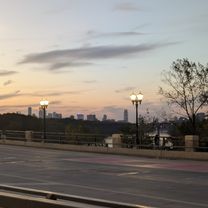
At this point you can continue across Hiawatha to E. 28th Street with the traffic signals or continue on the bike path to the north and over the Martin Sabo bridge.
Continua con Bikemap
Usa, modifica o scarica questo percorso ciclabile
Vuoi percorrere B2B00192 55102>55404viaShepherdRd/MissBlvd/WRiverPkwy/MidtwnGrnway o personalizzarlo per il tuo viaggio? Ecco cosa puoi fare con questo percorso su Bikemap:
Funzionalità gratuite
- Salva questo percorso tra i preferiti o in una raccolta
- Copia e pianifica la tua versione di questo percorso
- Sincronizza il tuo percorso con Garmin o Wahoo
Funzionalità Premium
Prova gratuita di 3 giorni o pagamento una tantum. Scopri di più su Bikemap Premium.
- Naviga questo percorso su iOS e Android
- Esporta un file GPX / KML di questo percorso
- Crea la tua stampa personalizzata (provala gratis)
- Scarica questo percorso per la navigazione offline
Scopri altre funzionalità Premium.
Ottieni Bikemap PremiumDalla nostra community
Saint Paul: Altri percorsi popolari che iniziano qui
 B2B00062 55106 - 55075 via Concord, NURT
- Distanza
- 9,5 km
- Salita
- 80 m
- Discesa
- 110 m
- Posizione
- Saint Paul, Minnesota, Stati Uniti
 B2B00418 55117>55123 via Cedar, Wabasha, Lexington, Pilot Knob Rd
- Distanza
- 20,8 km
- Salita
- 161 m
- Discesa
- 156 m
- Posizione
- Saint Paul, Minnesota, Stati Uniti
 To the River Center
- Distanza
- 17,1 km
- Salita
- 117 m
- Discesa
- 90 m
- Posizione
- Saint Paul, Minnesota, Stati Uniti
 B2B00192 55102>55404viaShepherdRd/MissBlvd/WRiverPkwy/MidtwnGrnway
- Distanza
- 21,8 km
- Salita
- 131 m
- Discesa
- 86 m
- Posizione
- Saint Paul, Minnesota, Stati Uniti
 B2B00368 55102 > 55417 via Shepard Rd, Godfrey, Minnehaha, River Pkwy
- Distanza
- 17,8 km
- Salita
- 96 m
- Discesa
- 119 m
- Posizione
- Saint Paul, Minnesota, Stati Uniti
 River Ramble 20
- Distanza
- 29,6 km
- Salita
- 196 m
- Discesa
- 197 m
- Posizione
- Saint Paul, Minnesota, Stati Uniti
 Jackson Street to East 7th Street
- Distanza
- 1,6 km
- Salita
- 36 m
- Discesa
- 0 m
- Posizione
- Saint Paul, Minnesota, Stati Uniti
 St Paul Gateway to: Brown’s creek to Stillwater and back .
- Distanza
- 64,2 km
- Salita
- 408 m
- Discesa
- 409 m
- Posizione
- Saint Paul, Minnesota, Stati Uniti
Aprila nell’app